Nantou county
|
Nantou County 南投 縣 |
||
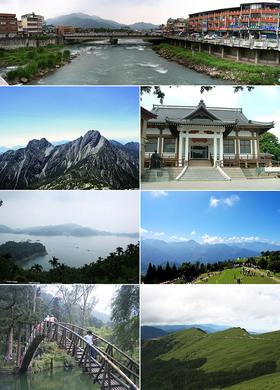
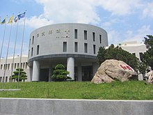
 From left to right and top to bottom: River in Shuili, Yushan Mountains, History Museum in Nantou, Sun Moon Lake - as seen from Xuanzang Temple in Yuchi, Qingjing Farm in Ren'ai, Xitou Nature Education Park in Lugu , Hehuanshan |
||
|
||
| State : |
|
|
| Founded : | 1950 | |
| Coordinates : | 23 ° 55 ' N , 120 ° 41' E | |
| Height : | 55 - 3952 m | |
| Area : | 4,106.4360 km² | |
| Residents : | 499,531 (May 2018) | |
| Population density : | 122 inhabitants per km² | |
| Time zone : | UTC + 8 (Chungyuan time) | |
| Telephone code : | (+886) (0) 49 | |
| Postal code : | 540-542, 544-546, 551-553, 555-558 | |
| ISO 3166-2 : | TW-NAN | |
| District capital : | Nantou ( 南投市 ) | |
| Structure : | 1 city ( 市 ), 4 urban parishes ( 鎮 ), 8 rural parishes ( 鄉 ) |
|
| District Administrator: | Lin Ming-cheng ( 林明 溱 ) ( KMT ) | |
| Website : | ||
| Circle flower: | Ume | |
| Circle tree: | Camphor tree | |

|
||
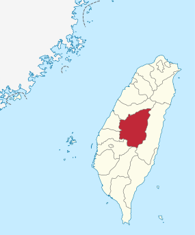
The district of Nantou ( Chinese 南投 縣 , Pinyin Nántóu Xiàn , Tongyong Pinyin Nántóu Siàn , W.-G. Nan-t'ou Hsien , Pe̍h-ōe-jī Lâm-tâu-kōan ) is a district of the Republic of China in Taiwan . It is located in the center of the island of Taiwan and is the only one of all counties in the Republic of China to have no sea coast. The capital is the city of Nantou .
history
The first inhabitants of the area of what is now Nantou were Austronesian ethnic groups, the ancestors of today's indigenous peoples of Taiwan . After the island of Taiwan came to the Chinese Empire of the Qing Dynasty in 1683 , the immigration of Han Chinese people began, mainly from the southern coastal provinces of Guangdong and Fujian . Initially, the region was administratively part of the Zhuluo County and from 1723 to the newly established Changhua County . During the time of the Japanese rule over Taiwan (1895-1945) a major administrative reorganization took place in 1920 and Taiwan was divided into prefectures. One of them was Taichu Prefecture , which comprised the current administrative units of Taichung , Nantou County and Changhua County. After Taiwan came to the Republic of China in 1945 , the old administrative units were essentially retained and the Taichung District was formed from the prefecture . In 1950, the areas of Changhua and Nantou were separated and became independent counties. The Nantou County Council began operating on October 21, 1950.
Geography and climate
The district is largely part of the central mountain range of Taiwan. Only in the west do the foothills of the flat and hill country of western Taiwan reach into the district area. There are the two largest settlements with the district town of Nantou and Caotun . In the south of the district is Yushan , which is surrounded by the national park of the same name and at 3,952 m the highest mountain in Taiwan and East Asia . The central part of the circle around the city of Puli lies on the west side of the main ridge of the mountain range. There is the sun-moon lake , a popular destination.
The average annual temperature is 23 ° C in the plains and 20 ° C in the mountains. The annual precipitation in the plains is 1,750 mm and in the mountains 2,800 mm. The rainy season lasts from April to September and the drier season from October to March.
traffic
The north-south highway 3 touches the district in the northwest in the area of the district town of Nantou, the branching off highway 6 , which opened in 2009, leads to the center of the district to Puli. There begins a pass road leading over the Hehuanshan to Hualien County , the only road in the center of the island that connects western and eastern Taiwan.
The Jiji Line , a branch line of the Taiwanese Railway , runs from Ershui in the neighboring district of Changhua via Jiji to Checheng in the community of Shuili near the Sun and Moon Lake.
cities and communes
The county town of Nantou is the only town ( 市 , Shì ) in the county. In addition, there are four urban communities ( 鎮 , Zhèn ) and eight rural communities ( 鄉 , Xiāng , including two mountain rural communities of the indigenous people). According to the official statistics from April 2018, the population figures and area data for the municipalities were as follows:
| local community | chin. | Hanyu Pinyin | Taiwanese (POJ) | Area (km²) |
Residents | Ew./km² |
|---|---|---|---|---|---|---|
| 1 city | ||||||
| Nantou | 南投市 | Nántóu | Lâm-tâu | 71.6021 | 99,985 | 1,397 |
| 4 municipalities | ||||||
| Caotun | 草屯 鎮 | Cǎotun Zhen | Chhau-tūn-tìn | 104.0327 | 97,640 | 939 |
| Jiji | 集 集鎮 | Jíjí Zhèn | Chi̍p-chi̍p-tìn | 49.7268 | 10,911 | 219 |
| Puli | 埔里 鎮 | Pǔlǐ Zhèn | Po͘-lí-tìn | 162.2227 | 80,786 | 498 |
| Zhushan | 竹山 鎮 | Zhúshān Zhen | Tek-san-tìn | 247.3339 | 54,955 | 222 |
| 6 rural communities | ||||||
| Guoxing | 國 姓 鄉 | Guóxìng Xiāng | Kok-sèng-hiong | 175.7042 | 18,757 | 107 |
| Lugu | 鹿谷 鄉 | Lùgǔ Xiāng | Lo̍k-kok-hiong | 141.8991 | 17,787 | 125 |
| Mingjian | 名 間 鄉 | Míngjiān Xiāng | Bêng-kan-hiong | 83.0955 | 38,586 | 465 |
| Shuili | 水里 鄉 | Shuǐlǐ Xiāng | Chúi-lí-hiong | 106.8424 | 17,714 | 167 |
| Yuchi | 魚池 鄉 | Yúchí Xiāng | Hî-tî-hiong | 121.3735 | 15,860 | 131 |
| Zhongliao | 中寮 鄉 | Zhōngliáo Xiāng | Tiong-liâu-hiong | 146.6541 | 14,783 | 100 |
| 2 mountainous communities of the indigenous people | ||||||
| Ren'ai | 仁愛 鄉 | Rén'ài Xiāng | Jîn-ài-hiong | 1,273.53 | 15,853 | 12 |
| Xinyi | 信義 鄉 | Xìnyì Xiāng | Sìn-gī-hiong | 1,422.42 | 16,262 | 11 |
The town of Zhongxing , which was planned in the area of Nantou City , has been home to the administration of Taiwan Province since 1956 .
| Municipalities in Nantou County |
|---|
politics
The self-governing body of the district is the elected district council of Nantou ( 南投 縣 議會 , Nántóu Xiàn Yìhuì ), which was established in 1950. The head of the district is the elected district administrator ( 縣長 , Xiàn zhǎng , English magistrate ). By 2018, almost all incumbent district administrators in Nantou belonged to the Kuomintang .
Individual evidence
- ↑ 歷史 沿革 ("Historical Development"). Nantou County website, March 26, 2018, accessed September 17, 2019 (Chinese (traditional)).
- ↑ Home> Profile of Nantou County. Nantou County, accessed September 28, 2017 .
- ↑ 各 月 人口 資料 (括弧 內 為 資料 起始 年月) 03 鄉鎮 戶數 及 人口 數 (9701) ("Population data for each month (in brackets is the starting month of the data) 03 municipalities and population (9701)"). Taiwan Ministry of the Interior, accessed May 11, 2018 (Chinese).
- ↑ 南投 縣 議會 (Nantou County Council). Retrieved November 28, 2018 (Chinese, District Council website).
- ↑ 南投 縣 歷任 縣長 (District administrators who presided over Nantou County). County government website, accessed November 28, 2018 (Chinese).


