
Lugu (Nantou)
|
Lugu 鹿谷 鄉 |
|||
.svg) Location Lugus in the Nantou district |
|||
| State : |
|
||
| County : | Nantou | ||
| Coordinates : | 23 ° 45 ' N , 120 ° 44' E | ||
| Height : | approx. 100 - 2194 m | ||
| Area : | 141.8981 km² | ||
| Residents : | 17,700 (Sep. 2018) | ||
| Population density : | 125 inhabitants per km² | ||
| Time zone : | UTC + 8 (Chungyuan time) | ||
| Telephone code : | (+886) (0) 49 | ||
| Postal code : | 558 | ||
| ISO 3166-2 : | TW-NAN | ||
| Community type : | Rural community ( 鄉 , Xiāng ) | ||
| Structure : | 13 villages ( 村 , Cūn ) | ||
| Mayor : | Qiu Ruping ( 邱如平 ) (independent) | ||
| Website : | |||
|
|||

Lugu ( Chinese 鹿谷 鄉 , Pinyin Lùgǔ Xiāng ) is a rural community ( 鄉 , Xiāng ) in the district of Nantou in central Taiwan .
location
Lugu is located in the western part of Nantou County. The municipality has an east-west extension of a maximum of about 10.5 kilometers and a north-south extension of about 16 kilometers. In the north it borders on the Zhuoshui River , which forms the northern boundary to the neighboring community of Jiji and is dammed there by the Jiji weir . Shuili and Xinyi parishes are to the east, and Zhushan parishes are adjacent to the west and south . Lugu lies on the border between the Alishan Mountains in the west and the Central Mountains in the east. The terrain is very changeable and varies greatly in height between about 100 and 2200 meters. The highest point is the Wuchalunshan ( 為 藤 湖山 ) at 2194 meters . Other mountain peaks are Fenghuangshan ( 鳳凰 山 , 1697 m), Shiyashan ( 石 牙山 , 1171 m), Qilinshan ( 麒麟 山 , 743 m) and Dongdingshan ( 凍 頂 山 , 740 m). The lowest point is the Tenghushan ( 藤 湖山 , 296 m).
Lugu has a mild subtropical climate. The annual mean temperature is 23 ° C. The annual precipitation is about 2600 mm, whereby the rain is unevenly distributed over the seasons. The main precipitation is in the months of June to September, while the rest of the season is relatively dry. Fog over the mountains is common.
history
The documented history of Lugus begins in 1741 during the reign of Qianlong . The first name of the settlement was Lin Yipu ( 林 圮 埔 ). At the time of the Japanese colonial rule (1895–1945), Lugu was organized into an administrative center as Lugu Zhuang ( 鹿谷 庄 , literally "deer valley" or "ungulate valley village"). After the Republic of China took over Taiwan in 1945, this resulted in today's rural community of Lugu, which was divided into 8 villages by decree of the new provincial government on February 25, 1946. In 1950 Lugu became part of the new Nantou County. In 1955, two villages were ceded to the neighboring community of Shuili as part of an administrative reform. In 1978 Lugus was reorganized into 13 villages. The Xitou Nature Education Park (see below) was established in 1970 and the Fonghuanggu Bird and Nature Reserve (see below) in 1982 .
Lugu was severely affected by the Jiji earthquake on September 21, 1999, the epicenter of which was immediately north of Lugu. At that time, 22 of the 21,279 inhabitants of Lugus were killed.
administration
Lugu is divided into 13 villages ( 村 , Cūn ):
| Outline of Lugu |
|
|

1 Neihu ( 內 湖村 )
2 Heya ( 和 雅 村 )
3 Zhulin ( 竹林村 )
4 Zhufeng ( 竹 豐村 )
5 Fenghuang ( 鳳凰 村 )
6 Guangxing ( 廣 興村 )
7 Zhangya ( 彰 雅 村 )
8 Lugu ( 鹿谷 村 )
9 Yonglong ( 永隆 村 )
10 Chuxiang ( 初 鄉村 )
11 Xiufeng ( 秀峰 村 )
12 Qingshui ( 清水 村 )
13 Ruitian ( 瑞 田村 )
population
In the early years of the Republic of China on Taiwan, the population of Lugu rose from 20,571 in 1958 to 25,717 in 1970. Since then, the population has decreased almost continuously to 17,700 in 2018. Members of indigenous peoples made up only 0.3 percent of the population at the end of 2017 (55 people).
Infrastructure
In the north of Lugu, the county road 131 runs roughly east-west. From it branches off in the village of Ruitian, the county road 139, which crosses the Zhuoshui and leads north to Jiji. In the west, the district road 131 in the village of Lugu joins the district road 151, which leads from the west (Zhushan) to the south to the Xitou Nature Education Park.
Agriculture and Forestry
Approximately 7448 hectares of the municipal area (52.5%) belong to state forests managed by the National Taiwan University . Mostly it is natural forest, which is declared as an experimental forest ( 實驗 林 ) and serves as a forest ecological research resource as well as is used for training. Part of the forest is also managed (e.g. as a bamboo forest). As for agricultural products, wet rice is grown in the village of Ruitian (near the Zhuoshui). Lugu is best known for the production of tea. In 1855, Lin Fengchi ( 林鳳池 ) brought some tea bushes from the Wuyi Mountains of the Chinese coastal province of Fujian to Lugu. This oolong tea was first successfully cultivated on the Dongdingshan mountain ("ice summit mountain ") and developed into its own type of oolong ( dongding tea , 凍 頂 茶 ) in Taiwan . Around 2000 tons of Dongding Wulong tea are harvested annually on around 2000 hectares .
Another 2800 hectares of cultivation area is taken up by the production of bamboo shoots ( Mengzong or winter bamboo shoots , Moso bamboo ), which corresponds to more than half of the total production of this variety in Taiwan.
Angelica spices are grown in small quantities ( Angelica japonica , 山 芹菜 , Shān qíncài , "mountain celery"), especially in Heya and Fenghuang, and to a lesser extent Angelica keiskei ( 明日 葉 , Míngrì yè - "morning leaf"), mainly near the Xitou- Nature educational park. Trout farming is also practiced in Lugu .
Attractions
The main attraction in Lugu is the natural and cultural landscape. In the village of Yonglong there is the small, man-made Qilintan Lake ( 麒麟 潭 , 13 ha). The approximately 2500 hectare nature teaching park Xitou ( 溪頭 教育 園區 ) in the southwest of Lugu is operated by the National University of Taiwan . It is used for teaching and training purposes, but is accessible to the general public. The Fonghuanggu Bird and Nature Reserve ( 鳳凰 谷 鳥 園 生態 園區 ) in Fenghuang Village is home to more than 300 rare species of birds from Taiwan and around the world on more than 30 hectares. The park is under the direction of the National Museum of Science in Taichung .

Forest in Neihu
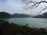
Qilintan -See

Entrance to the Xitou Nature Education Park
.jpg)


Web links
Individual evidence
- ^ Geography. Lugu website, accessed December 27, 2018 .
- ↑ 自然環境 (natural environment). Lugu website, accessed December 27, 2018 (Chinese).
- ^ History. Lugu website, accessed December 27, 2018 .
- ↑ 歷史 沿革 ("Historical Development"). Lugu website, accessed December 27, 2018 (Chinese).
- ↑ Han SN, Chen KT: Mortality of the 921 Earthquake in Nantou and Taichung Counties . In: Epidemiology Bulletin . January 25, 2000, ISSN 1021-366X , p. 1–8 (English, online [PDF]).
- ↑ 行政 區域 ("administrative regions"). Lugu website, accessed December 27, 2018 (Chinese).
- ↑ 47 年 起 歷年 人口 增減 表 (“Table of the increase and decrease in the population for the last 47 years”). Lugu Household Registration Authority, accessed December 27, 2018 (Chinese).
- ↑ 原住民 戶數 及 人數 Households and Persons of Indigenous People. (xls) Taiwan Ministry of the Interior, accessed May 19, 2018 (Chinese / English).
- ↑ 特產 介紹 (“Introduction to the specialties”). Lugu website, accessed December 27, 2018 (Chinese).
- ^ Special Products. Lugu website, accessed December 27, 2018 .
- ↑ 溪頭 自然 教育 園區. Retrieved December 28, 2018 (Chinese, English, park website).
- ↑ 鳳凰 谷 鳥 園 生態 園區 ("Fonghuanggu Bird and Nature Reserve"). Retrieved December 28, 2018 (Chinese, English, park website).