
Zhongliao
|
Zhongliao 中寮 鄉 |
|||
.svg) Location Zhongliaos in Nantou County |
|||
| State : |
|
||
| County : | Nantou | ||
| Coordinates : | 23 ° 54 ' N , 120 ° 47' E | ||
| Height : | 200 - 1264 m | ||
| Area : | 146.6541 km² | ||
| Residents : | 14,745 (Sep 2018) | ||
| Population density : | 101 inhabitants per km² | ||
| Time zone : | UTC + 8 (Chungyuan time) | ||
| Telephone code : | (+886) (0) 49 | ||
| Postal code : | 541 | ||
| ISO 3166-2 : | TW-NAN | ||
| Community type : | Rural community ( 鄉 , Xiāng ) | ||
| Structure : | 18 villages ( 村 , Cūn ) | ||
| Mayor : | Zhang Yonghui ( 張永輝 ) ( KMT ) | ||
| Website : | |||
|
|||

Zhongliao ( Chinese 中寮 鄉 , Pinyin Zhōngliáo Xiāng , Tongyong Pinyin Jhongliáo Siang ) is a rural community ( 鄉 , Xiāng ) in Nantou County in central Taiwan .
Location and climate
The municipality of Zhongliao has approximately the shape of a square with an edge length of 12 kilometers. The neighboring communities are Mingjian , Nantou in the west, Caotun in the north, Guoxing and Shuili in the east, and Jiji in the south. The terrain is characterized by hills and mountains and the mean height above sea level varies between 200 and 1264 meters. About 143 km² (approx. 97.8%) of the municipal area are taken up by mountain land and only about 3 km² (2.3%) are plains. The climate is subtropical , but much more moderate in altitude. With the exception of the winter months from December to March, the monthly average temperature is consistently over 20 ° C. The highest temperatures are reached in the months of July and August. The annual precipitation is around 2200 mm. The rainy season extends from May to August, while the dry season runs from October to March. In winter the northwest wind dominates and in summer the wind from the southeast.
history
The indigenous people of the area are Austronesian ethnic groups (members of the indigenous peoples of Taiwan ). After the island of Taiwan became part of the Chinese Empire in the late 17th century , Han Chinese settlers poured into the country. The area around today's Zhongliao was mainly settled by immigrants who came from the area of Zhangzhou in the Chinese coastal province of Fujian .
Residents
With around 14,700 inhabitants (as of 2018), Zhongliao was the second to last place among the municipalities in Nantou County (only neighboring Jiji had fewer inhabitants). According to official statistics, 67 people belonged to the indigenous peoples at the end of 2017. This corresponded to a share of almost 0.5%.
Agriculture
Agriculture mainly takes place on the mountain slopes, where irrigation management is difficult. Therefore z. B. the otherwise typical wet rice cultivation. Products of local agriculture are bananas , citrus fruits (harvest from October to February), longan , lychee , persimmon , bamboo shoots and Erjian -Tee ( 二尖茶 , a mild Oolong , which is grown at high altitudes).
traffic
National road 3 (highway) runs for a short distance through the extreme western tip of Zhongliao. Coming from Nantou, county road 139 runs south through the southwest of Zhongliao. All other streets are smaller municipal streets.
administration
| Outline of Zhongliao |
|
|

Zhongliao is divided into 18 villages ( 村 , Cūn ):
1 Yihe ( 義 和村 )
2 Yongfu ( 永福 村 )
3 Yongping ( 永平 村 )
4 Kanding ( 崁 頂 村 )
5 Guangxing ( 廣 興村 )
6 Baxian ( 八仙 村 )
7 Fusheng ( 福 盛 村 )
8 Hexing ( 和 興村 )
9 Fuxing ( 復興 村 )
10 Zhongliao ( 中 寮村 )
11 Guangfu ( 廣 福村 )
12 Qingshui ( 清水 村 )
13 Neicheng ( 內 城 村 )
14 Longan ( 龍 安 村 )
15 Shuangwen ( 爽 文 村 )
16 Longyan ( 龍岩村 )
17 Yongfang ( 永 芳村 )
18 Yonghe ( 永和 村 )
Tourism, sightseeing
The main attraction of Zhongliao are the natural sights. This includes the Longfeng ( 龍鳳 瀑 ) waterfall ("Dragon and Phoenix Waterfall") in the village of Qingshui. In the village of Fusheng there is the Qianzhang rock ( 千丈 岩 , thousand-foot rock), an 80 × 100 meter large, about 70 degree steep rock wall. There is a picturesque view from Mount Erjian ( 二 尖山 ). There are also bamboo forests and tea plantations there. Various temples are also worth seeing, for example the Buddhist Heart Buddha Temple ( 心 佛寺 , Xīn fó sì ) in the village of Qingshui , built in 1980 .
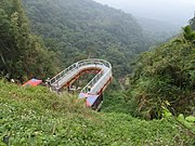
Longfeng Waterfall Skywalk

Shuangwen village

Xinfo temple


Web links
Individual evidence
- ^ Geography & Population. Zhongliao website, accessed December 1, 2018 .
- ^ History. Zhongliao website, accessed December 1, 2018 .
- ↑ 原住民 戶數 及 人數 Households and Persons of Indigenous People. (xls) Taiwan Ministry of the Interior, accessed May 19, 2018 (Chinese / English).
- ↑ 農業 風采 (Agricultural Products). Zhongliao website, accessed December 1, 2018 (Chinese).
- ↑ 地圖 指引 ("Map Guide"). Zhongliao website, accessed December 1, 2018 .
- ↑ 地理 環境 ("Geographical Environment"). Zhongliao website, accessed December 1, 2018 (Chinese).
- ↑ 行政 區域 圖 ("administrative area map"). Zhongliao website, accessed December 1, 2018 (Chinese).
- ↑ a b (Good Mountain and Good Water) - Longfeng Waterfall. Zhongliao website, accessed December 1, 2018 .
- ↑ Scenic Erjian Mountain. Zhongliao website, accessed December 1, 2018 .
- ↑ 宗教信仰 ("Religious Belief"). Zhongliao website, accessed December 1, 2018 (Chinese).