
Caotun
|
Caotun 草屯 鎮 |
|||
.svg) Location Caotuns in Nantou County |
|||
| State : |
|
||
| County : | Nantou | ||
| Coordinates : | 23 ° 59 ' N , 120 ° 44' E | ||
| Area : | 104.0327 km² | ||
| Residents : | 97.273 (Sep. 2018) | ||
| Population density : | 935 inhabitants per km² | ||
| Time zone : | UTC + 8 (Chungyuan time) | ||
| Telephone code : | (+886) (0) 49 | ||
| Postal code : | 542 | ||
| ISO 3166-2 : | TW-NAN | ||
| Community type : | City municipality ( 鎮 , Zhèn ) | ||
| Structure : | 27 districts ( 里 , Lǐ ) | ||
| Mayor : | Hong Guohao ( 洪國浩 ) ( DPP ) | ||
| Website : | |||
|
|||

Caotun ( Chinese 草屯 鎮 , Pinyin Cǎo tún , W.-G. Ts'ao³-t'un² ) is a township ( 鎮 , Zhèn ) in the district of Nantou in central Taiwan .
location
Caotun is located in the north-west of Nantou County. The municipality has approximately the shape of a lying rectangle with an edge length of 6.5 × 16 kilometers. The neighboring municipalities are Guoxing in the east, Zhongliao and Nantou in the south, Fenyuan (Changhua County) to the west and the District Wufeng of Taichung in the north. Caotun is traversed by the river Wu ( 烏 溪 , Wū xī ). The terrain is relatively flat and geologically corresponds to an alluvial plain .
history
The original inhabitants of the area were members of the indigenous peoples of Taiwan ( Hoanya , Arikun and Tausabata). From the 18th century, the gradual immigration of Han Chinese began, who either acculturated the indigenous population or pushed them to the more to the east, inaccessible mountains. During the Japanese rule of Taiwan , Caotun was made a local administrative center in 1938. After the defeat of Japan in World War II, the island of Taiwan became part of the Republic of China . In 1950 Caotun became a township in the newly established Nantou County.
Residents
With almost 100,000 inhabitants, Caotun is the second most populous municipality in Nantou County after Nantou. After the population had grown continuously for a long time since the end of the Second World War, it stagnated around the year 2000 shortly before the 100,000-inhabitant mark, or it tended to decline again. At the end of 2017, according to official statistics, 536 people belonged to the indigenous peoples (around 0.6%).
Administrative division
Caotun is divided into 27 districts ( 里 , Li ):
1 Zhongshan ( 中山 里 )
2 Yufeng ( 玉峰 里 )
3 Mingzheng ( 明 正 里 )
4 Yanfeng ( 炎 峰 里 )
5 Heping ( 和平 里 )
6 Dunhe ( 敦 和 里 )
7 Futun ( 富 寮 里 )
8 Zhongzheng ( 中正里 )
9 Xinyi ( 新厝 里 )
10 Shanjia ( 山腳 里 )
11 Bizhou ( 碧 洲 里 )
12 Bifeng ( 碧峰 里 )
13 Yushi ( 御史 里 )
14 Fuxing ( 復興 里 )
15 Zhongyuan (
中原里 )
16 Jialao ( 茄 荖 里 )
17 Beitou ( 北投 里 )
18 Shichuan ( 石川 里 )
19 Nanpu ( 南 埔里 )
20 Xinzhuang ( 新 庄里 )
21 Xinfeng ( 新豐 里 )
22 Shanglin ( 上林 里 )
23 Tucheng ( 土城 里 )
24 Beizhi ( 北 勢 里 )
25 Pinglin ( 平林 里 )
26 Pingding ( 坪 頂 里 )
27 Shuangdong ( 雙 冬 里 )
| Outline of Caotun |
|
|

economy
Caotun was badly hit by the so-called 921 earthquake in 1999, which destroyed numerous buildings and claimed 87 lives in the municipality, which then had 96,833 inhabitants. In the following years the city was rebuilt as planned. Caotun is also a rice growing center in Nantou County.
traffic
Caotun has a direct motorway connection via the national road 3, which runs in north-south direction. In a westerly direction, Caotun is connected to the city of Yuanlin in the district of Changua by the Baguashan Tunnel, which was opened in 2005 and is almost 5 kilometers long on Provincial Road 76 .
Educational institutions
The Nan Kai Technical University (NKUT) is located in Caotin.
Attractions
In Caotun is the National Taiwan Craft Research and Development Institute ( 國立 臺灣 工藝 研究 發展 中心 , English National Taiwan Craft Research and Development Institute ). Exhibitions, workshops, markets, conferences etc. all about the craft take place here. The largest bronze statue of the deity Cai Shen in Taiwan is located on the Dun Ho Temple ( 敦 和 宮 ) in Caotun . The landscape around the Jiujiufeng ( 九九峰 - "Jiujiu summit"), an almost 800 meter high mountain that extends into the neighboring community (the district) of Wufeng from Taichung, is worth seeing .

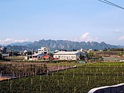
Caotun business district
Landscape around Jiujiufeng ( 九九峰 )

Dun Ho Temple ( 敦 和 宮 ) in Caotun


Personalities
- Wu Den-yih (* 1948 in Caotun), former Vice Prime Minister and party leader of the Kuomintang
Web links
Individual evidence
- ↑ a b Knowing Caoxiedun. English-language website of the Caotun municipality, accessed on November 22, 2018 (English).
- ↑ 草屯 沿革 ("History of Caotun"). Caotun website, accessed November 22, 2018 (Chinese).
- ↑ 原住民 戶數 及 人數 Households and Persons of Indigenous People. (xls) Taiwan Ministry of the Interior, accessed May 19, 2018 (Chinese / English).
- ^ Administrative area. English-language website of the Caotun municipality, accessed on November 22, 2018 (English).
- ↑ 各 里 資料 ("Data on the respective districts"). Caotun website, accessed November 23, 2018 (Chinese).
- ↑ Han SN, Chen KT: Mortality of the 921 Earthquake in Nantou and Taichung Counties . In: Epidemiology Bulletin . January 25, 2000, ISSN 1021-366X , p. 1–8 (English, online [PDF]).
- ^ City Construction. English-language website of the Caotun municipality, accessed on November 22, 2018 (English).
- ↑ Rice. English-language website of the Caotun municipality, accessed on November 22, 2018 (English).
- ↑ 南開 科技 大學 Nan Kai University of Technology. University website, accessed April 4, 2019 .
- ^ National Taiwan Craft Research Institute. English-language website of the Caotun municipality, accessed on November 22, 2018 (English).