
Ren'ai (Nantou)
|
Ren'ai 仁愛 鄉 |
|||
.svg) Location Ren'ais in Nantou County |
|||
| State : |
|
||
| County : | Nantou | ||
| Coordinates : | 24 ° 3 ' N , 121 ° 8' E | ||
| Height : | 400 - 3590 m | ||
| Area : | 1,273.5312 km² | ||
| Residents : | 15,969 (Dec 2018) | ||
| Population density : | 13 inhabitants per km² | ||
| Time zone : | UTC + 8 (Chungyuan time) | ||
| Telephone code : | (+886) (0) 49 | ||
| Postal code : | 546 | ||
| ISO 3166-2 : | TW-NAN | ||
| Community type : | Rural community ( 鄉 , Xiāng ) | ||
| Structure : | 16 villages ( 村 , Cūn ) | ||
| Mayor : | Wu Wenzhong ( 吳文忠 ) | ||
| Website : | |||
|
|||

Ren'ai ( Chinese 仁愛 鄉 , Pinyin Rén'ài Xiāng ) is a rural community ( 鄉 , Xiāng ) in the district of Nantou in central Taiwan .
description
Ren'ai is the second largest community in Nantou County, covering an area of 1,273 km², and the third largest in Taiwan. The municipal area lies entirely in the area of the Taiwanese Central Mountains and is characterized by mountains that reach heights of over 3000 meters and narrowly cut valleys. The elevation varies from 400 meters in the Beigang river plain in Huzhu village to the 3,590 meter high main peak of Qilaishan ( 奇萊 山 , ) on the border with Hualien County . In general, the altitude increases from west to east. There are more than 70 mountain peaks over 2000 meters high. Some of the more popular include Hehuanshan ( 合歡 山 ), Nenggaoshan ( 能 高山 ), Zhuoshedashan ( 卓 社 大 山 ), Guandaoshan ( 關 刀山 ) and Shouchengdashan ( 守城 大 山 ).
![]()

The neighboring communities of Ren'ai are Heping in Taichung in the north, Xiulin and Wanrong in Hualien County in the east, Xinyi in the south, and Yuchi , Puli and Guoxing in the west. In the northeast, the municipality includes a part (77 km²) of the Taroko National Park and two smaller nature parks, the National Forest Recreation Area Aowanda ( 奧 萬 大 國家 森林 遊樂 區 , Àowàndà guójiā sēnlín yóulè qū ) and the National Forest Recreation Area Hehuanshan ( 森林 山 山區 , Héhuānshān guójiā sēnlín yóulè qū ).
The headwaters of the Zhuoshui are located in Ren'ai , including the Wushe ( 霧 社 溪 , Wùshè Xī ) coming from the northeast and the Wanda ( 萬 ⼤ 溪 , Wàndà Xī ) coming from the east . The former is dammed up by the Wushe Dam to the Wushe Reservoir. In the north of Ren'ai the river Beigang ( 北港溪 , Běigǎng Xī ) rises, which flows in a westerly direction to the neighboring municipality of Guoxing.
The climate of Ren'ai is subtropical, but clearly moderate due to the altitude. There are significant temperature differences between day and night. The annual mean temperature is 18 ° C with the highest temperatures between June and September and the mean annual precipitation is 2100 mm. The effects of the typhoons that regularly occur in Taiwan are mitigated by the high mountain location.
history
The original inhabitants of the area were members of the Austronesian indigenous people of Taiwan. During the time that Taiwan belonged to the Chinese Empire (1683 to 1895), the inaccessible area was practically not under the control of the Chinese administration and was not settled by the Han Chinese . The administrative penetration and subjugation of the indigenous population did not take place until the time of Japanese colonial rule (1895–1945). During this time, Ren'ai was also the center of the largest revolt against the Japanese, the so-called Wushe uprising . In this uprising from October to December 1930, the Sediq rose against the colonial rulers under their leader Mona Rudao . The uprising claimed several thousand lives on both sides and the colonial administration crushed it with great severity. The Japanese took advantage of the hostility between different tribes. After Taiwan was transferred to the Republic of China in 1945, Ren'ai was organized as a rural community in Nantou County, which was newly established in 1950.
population
With a population density of only 11 people per km², Ren'ai is one of the most sparsely populated areas of Taiwan (average population density in Taiwan:> 600 U / km²). The ethnic makeup of Ren'ai is complex. At the end of 2017, 12,666 people (almost 80%) belonged to the indigenous peoples of Taiwan . According to the website of the municipality (but undated) including 2631 were Bunun 9751 (mainly in the villages Wanfeng, Fazhi, Zhongzheng) ,, Sediq (mainly in Hezuo, Jingying, Chunyang, Nanfeng, Huzhu). and 2613 Atayal (Faxiang, Lixing, Cuihua, Xinsheng Villages). Another ethnic minority group are the Dai . After the end of the Chinese Civil War , remnants of the defeated Kuomintang troops fled to Burma , from where they repeatedly launched offensives in the Chinese province of Yunnan ( Kuomintang in Burma ). There were some close ties between the local hill tribes and the Kuomintang soldiers, and when the last Kuomintang soldiers were evacuated to Taiwan, more than 200 members of the Dai people moved with them in 1961. There they received 765 hectares of freshly cleared, hilly farmland in the municipality of Ren'ai, in a landscape that was reminiscent of their old homeland. Today there are official efforts to preserve or revive their original culture.
Administrative division
| Outline of Ren'ai |
|
|

Ren'ai is divided into 16 villages ( 村 , Cūn ):
1 Rongxing ( 榮興 村 )
2 Cuihua ( 翠華 村 )
3 Lixing ( 力行 村 )
4 Faxiang ( 發祥 村 )
5 Datong ( 大同 村 )
6 Hezuo ( 合作 村 )
7 Douda ( 都 達 村 )
8 Jingying ( 精英 村 )
9 Chunyang ( 春陽 村 )
10 Qin'ai ( 親愛 村 )
11 Fazhi ( 法治 村 )
12 Zhongzheng ( 中正 村 )
13 Wanfeng ( 萬豐 村 )
14 Nanfeng ( 南豐 村 )
15 Xinsheng ( 新生 村 )
16 Huzhu ( 互助村 )
Transport links
A major east-west road link runs through Ren'ai. Coming from Puli in the west, Provincial Road 14 heads east and ends in Jingying Village. To the north of the Wushe Reservoir, provincial road 14A (14 甲 ) branches off from it , which leads in a north-easterly direction from Hehuanshan to Xiulin (Hualien County).
Landmarks, tourism
In addition to the national and nature parks already mentioned above, which offer many opportunities for nature tourism, there are a number of other attractions. The Qingjing Farm ( 清境 農場 ) in Datong Village was established in 1961 as a model farm in the Alpine style. The Wushe Uprising Memorial Park ( 霧 社 事件 紀念 公園 ) commemorates the resistance against the Japanese colonizers. The Lushan Hot Springs ( 廬山 溫泉 ) in Jingying Village are also a tourist destination.

View of the Hehuanshan
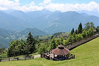
View of the surrounding area from Qingjing Farm
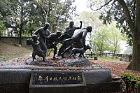
Monument to the Wushe Rising


Web links
Individual evidence
- ↑ a b 地理 與 環境 ("Geography and Environment"). Ren'ai website, 2016, accessed January 26, 2019 (Chinese).
- ↑ Aowanda National Forest Recreation Area. Taiwan Tourism Bureau, 2016, accessed January 26, 2019 .
- ^ Hehuanshan National Forest Recreation Area. Taiwan Tourism Bureau, 2016, accessed January 26, 2019 .
- ↑ 原住民 戶數 及 人數 Households and Persons of Indigenous People. (xls) Taiwan Ministry of the Interior, accessed August 4, 2018 (Chinese, English).
- ↑ 族群: 布 農 族 概述 ("Ethnic group: Bunun overview"). Ren'ai website, accessed January 26, 2019 (Chinese).
- ↑ 族群: 賽德克 族 的 分佈 ("Ethnic group: distribution of the Sediq"). Ren'ai website, accessed January 26, 2019 (Chinese).
- ↑ 族群: 泰雅族 概述 ("Ethnic group: Atayl overview"). Ren'ai website, accessed January 26, 2019 (Chinese).
- ↑ 族群: 擺 夷族 概述 ("Ethnic Group: Overview of the Dai People"). Ren'ai website, accessed January 26, 2019 .
- ↑ 文化局 出版品 (“Publications of the Culture Office”). Nantou County Culture Bureau, accessed January 26, 2019 (Chinese).
- ↑ 村落 (list of villages). Ren'ai website, accessed January 26, 2019 (Chinese).
- ^ Qingjing Farm. Taiwan Tourism Office, accessed January 26, 2019 .
- ↑ Lushan Hot Spring. Nantous Tourism Authority, accessed January 26, 2019 .