
Xiulin (Hualien)
|
Xiulin 秀林 鄉 |
|||
.svg) Location of Xiulin in Hualien County |
|||
| State : |
|
||
| County : | Hualien | ||
| Coordinates : | 24 ° 13 ' N , 121 ° 32' E | ||
| Area : | 1,641.8555 km² | ||
| Residents : | 15,902 (June 2018) | ||
| Population density : | 10 inhabitants per km² | ||
| Time zone : | UTC + 8 (Chungyuan time) | ||
| Telephone code : | (+886) (0) 3 | ||
| Postal code : | 972 | ||
| ISO 3166-2 : | TW-HUA | ||
| Community type : | Rural community ( 鄉 ) | ||
| Structure : | 9 villages ( 村 ) | ||
| Website : | |||
|
|||

Zhuoxi ( Chinese 秀林 鄉 , Pinyin Xiùlín Xiāng ) is a rural community in Hualien County in the Republic of China, Taiwan .
Location and climate
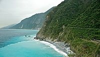
With almost 1642 km², Xiulin is not only the largest municipality in the district of Hualien, but also in the whole of Taiwan. The municipality has approximately the dimensions of a rectangle with the edge lengths 86 × 30 kilometers. The municipal area is predominantly in the area of the Taiwan Central Mountains . 93% of the municipality consists of mountainous land and only 3% of plains. The remaining 4% are taken up by bodies of water. More than 20 mountain peaks in Xiulin reach a height of over 3000 meters. In the northern section the mountains reach directly to the sea and form a cliff-cliff coast in sections . The picturesque Qingshui cliff located there is known far beyond Taiwan and has even become the subject of an international dispute, as the People's Republic of China also officially counts it among its top attractions.
Due to the mountainous topography, the population density is very low at around 10 per km² (Taiwanese average: over 600 inhabitants / km²). Xiulin is an international tourist destination due to its natural sights, especially the Taroko National Park . The climate is subtropical, rainy and characterized by the monsoons , but varies with the height above sea level. Very cool temperatures are also reached in mountainous areas.
To the west, Xiulin borders directly on the Pacific Ocean to the north, and further south on the communities of Xincheng , Hualien , Ji'an and Shoufeng . Xiulin is bordered by Wanrong Township to the south, Ren'ai in Nantou County to the west, and Nan'ao in Yilan County to the north .
history
The first historically tangible inhabitants of the area were members of the Austronesian natives of Taiwan . Around the 17th and 18th centuries, members of the Truku (Taroko) people migrated from the area of today's Nantou district towards the west to today's Xiulin, where they now form the majority of the population. When Taiwan became part of the Chinese Empire , the inaccessible area was largely left to its own devices. After the Sino-Japanese War of 1895, Taiwan came under Japanese rule and the Japanese administration made efforts to bring the entire island under their administrative control. The Truku put up armed resistance against it, which could only be broken with the use of considerable military means until 1914. In 1945, Japanese rule ended and Taiwan became part of the Republic of China . The area was administratively reorganized as the 'Shilin Rural Community' ( 士林 鄉 ). The name was later changed to 'Xiulin' because there was already another community with that name in northern Taiwan (now the Shilin District of Taipei ).
| Outline of Xiulin |
|
Heping
和平 村 Chongde
崇德 村 Fushi
富 世 村 ←
Xiulin
秀 林村 Jingmei
景美 村 Jiamin
佳 民 村 Shuiyuan
水源 村 Tongmen
銅門 村 Wenlan
文 蘭 村 |

Administrative division
Xiulin is divided into 9 villages ( 村 , Cūn ): Wenlan ( 文 蘭 ), Tongmen ( 銅門 ), Shuiyuan ( 水源 ), Jiamin ( 佳 民 ), Jingmei ( 景美 ), Fushi ( 富 世 ), Chongde ( 崇德 ), Heping ( 和平, ) and Xiulin ( 秀林 ).
population
According to official statistics, a total of 14,052 people (88%) belonged to the indigenous peoples at the end of 2017. Mostly it was Truku .
traffic
South of the mouth of the Liwu River (still in the adjacent Xinsheng municipality ), Provincial Road 9, which runs on the east coast of Taiwan, branches into Provincial Roads 9D (9 丁 ) and 8. The former continues north along the coast and the latter takes its way west through the Taroko Gorge. The north connecting line ( 北 迴 線 ) of the Taiwanese Railway, which has three stations in Xiulin (Heping, Heren and Chongde), runs parallel to the former .
economy
Several hydropower plants are located in Xiulin. The main industries are agriculture, which is mainly operated as a subsistence economy, and tourism.
Tourist destinations
The main attraction is the Taroko National Park, which is mostly (74,800 ha) in Xiulin, but also extends into the neighboring Nantou County and the Heping District of Taichung and counted around 4.5 million visitors in 2016.
Qingshui cliff

Xiulin Mountains

Taroko Gorge


Web links
Individual evidence
- ↑ 地理位置 ("Geographical Location"). Xiulin's website, accessed July 14, 2018 (Chinese).
- ↑ Jonathan Kaiman: Chinese passport map causes diplomatic dispute. The Guardian, November 27, 2012, accessed July 14, 2018 .
- ↑ 太魯閣 族 ("Truku"). Taiwan Digital Museum of Indigenous Cultures ( 臺灣 原住民 數 位 博物館 ), accessed July 14, 2018 (Chinese).
- ↑ 地方 人文 ("Local Population"). Xiulin's website, accessed July 14, 2018 (Chinese).
- ↑ 行政 區域 ("administrative regions"). Xiulin's website, accessed July 14, 2018 (Chinese).
- ↑ 原住民 戶數 及 人數 Households and Persons of Indigenous People. (xls) Taiwan Ministry of the Interior, accessed May 19, 2018 (Chinese / English).
- ↑ 統計 資料 (“Statistical Data”). National Parks of Taiwan, Retrieved July 14, 2018 (Chinese).
- ↑ 各 國家 公園 基本 資料 表 (“Basic information table about the national parks”). (No longer available online.) October 12, 2010, formerly in the original ; Retrieved October 26, 2018 (Chinese). ( Page no longer available , search in web archives ) Info: The link was automatically marked as defective. Please check the link according to the instructions and then remove this notice.
