
Yuli (Hualien)
|
Yuli 玉里 鎮 |
|||
.svg) Location of Yuli in Hualien County |
|||
| State : |
|
||
| County : | Hualien | ||
| Coordinates : | 23 ° 22 ' N , 121 ° 21' E | ||
| Area : | 252.3719 km² | ||
| Residents : | 24,235 (March 2018) | ||
| Population density : | 96 inhabitants per km² | ||
| Time zone : | UTC + 8 (Chungyuan time) | ||
| Telephone code : | (+886) (0) 3 | ||
| Postal code : | 975 | ||
| ISO 3166-2 : | TW-HUA | ||
| Community type : | City municipality ( 鎮 , Zhèn ) | ||
| Structure : | 15 districts ( 里 , Li ) | ||
| Mayor : | Gong Wenjun ( 龔文俊 ) ( KMT ) | ||
| Website : | |||
|
|||

Yuli ( Chinese 玉里 鎮 , Pinyin Yùlǐ Zhèn ) is a municipality in the district of Hualien in the Republic of China (Taiwan) .
location
Yuli Township is located in the central section of the Huatung Valley , which extends parallel to the east coast of the island of Taiwan. To the east, the valley and the municipality are bounded by the Haian Mountains and to the west by the Taiwanese Central Mountains. The length of the municipality along the valley floor is around 28.8 kilometers and the maximum transverse extent is around 10.4 kilometers. At the bottom of the valley, the Xiuguluan River flows through the municipality in a south-north direction. The neighboring communities are Fuli in the south, Changbin in Taitung County in the east, Fengbin in the northeast, Ruisui in the north and Zhuoxi in the west.
history
The original inhabitants of the area were members of the Austronesian indigenous peoples of Taiwan . From the second half of the 19th century, the immigration of Han Chinese people began. In 1875, the first year of the Qing Emperor Guangxu's reign , an administrative base was established in Yuli. The city took a major boom after it was connected to the Eastern Railway (today's Taitung Line ) in 1917 during the Japanese rule . After Taiwan came to the Republic of China in 1945 , Yuli was reorganized as a township and divided into 23 districts. In 1971 there was a new division into 15 districts.
| Outline by Yuli |
|
a: Yongchang 永昌 里
b: Taichang 泰昌 里
c: Qimo 啟 模 里
d: Guowu 國 武 里
e: Zhongcheng 中 城里
a
b
c
d
e
Dewu
德 武 里 Chunri
春日 里 Sanmin
三民 里 Songpu
松浦 里 Guanyin
觀音 里 Dayu
大禹 里 Dongfeng
東 豐 里 Yuancheng
源 城里 Lehe
樂 合 里 Changliang
長 良 里 |

Administrative division
Yuli is divided into 15 districts ( 里 , Li ): Dewu ( 德 武 里 ), Chunri ( 春日 里 ), Songpu ( 松浦 里 ), Guanyin ( 觀音 里 ), Lehe ( 樂 合 里 ), Yuancheng ( 源 城里 ) , Dongfeng ( 東 豐 里 ), Changliang ( 長 良 里 ), Zhongcheng ( 中 城里 ), Guowu ( 國 武 里 ), Taichang ( 泰昌 里 ), Dayu ( 大禹 里 ), Qimo ( 啟 模 里 ), Yongchang ( 永昌 里 ), Sanmin ( 三民 里 ).
population
Of the 24,209 inhabitants (May 2018), 7683 (31.7%) belonged to the indigenous peoples (6727 peoples of the plains, 956 peoples of the mountainous region).
Agriculture
Agricultural products of the region are sweet potatoes , corn, fire beans , taro , ginger and lemon daylilies ( Hemerocallis citrina , whose flower buds - 金针 , jīnzhēn , “ golden needles ” - are consumed as vegetables).
traffic
Important traffic arteries are the Taitung Line of the Taiwanese Railway, which runs through the Huatung Valley. There are two train stations in Yuli: Sanmin ( 三民 車站 ) and Yuli ( 玉里 車站 ). The main roads are the Provincial Road 9, which runs through the entire Huatung Valley, and the provincial road 30 ( "Yuchang Road" 玉長公路 ) of Zhuoxi crosses coming in the West Yuli and the Haian Mountains after Changbin to the coast leads.
Attractions
Tourist destinations include the nature of the Huatung Valley, the hot springs of Antong ( 安 通 溫泉 ) and the remains of shrines from the Japanese colonial era.
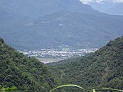
View of Yuli from provincial road 30 in the Haian Mountains

Railway station in Yuli

Daylily cultivation in Yuli


Web links
Individual evidence
- ↑ 玉里 簡介 ("Introduction to Yuli"). Yuli's website, accessed June 25, 2018 (Chinese).
- ↑ 行政 區域 ("administration area"). Yuli's website, accessed June 25, 2018 (Chinese).
- ↑ 人口統計 ("Demography"). Yuli's website, accessed June 25, 2018 (Chinese).
- ^ At tong Hot Spring Hotel. Retrieved June 26, 2018 (English, Chinese, Japanese).
