
Shoufeng
|
Shoufeng 壽 豐 鄉 |
|||
.svg) Location of Shoufeng in Hualien County |
|||
| State : |
|
||
| County : | Hualien | ||
| Coordinates : | 23 ° 51 ' N , 121 ° 33' E | ||
| Area : | 218.4448 km² | ||
| Residents : | 18,017 (March 2018) | ||
| Population density : | 82 inhabitants per km² | ||
| Time zone : | UTC + 8 (Chungyuan time) | ||
| Telephone code : | (+886) (0) 3 | ||
| Postal code : | 974 | ||
| ISO 3166-2 : | TW-HUA | ||
| Community type : | Rural community ( 鄉 ) | ||
| Structure : | 15 villages ( 村 ) | ||
| Mayor : | Zhang Huaiwen ( 張懷文 ) ( KMT ) | ||
| Website : | |||
|
|||

Shoufeng ( Chinese 壽 豐 鄉 , Pinyin Shòufēng Xiāng ) is a rural community in Hualien County in the Republic of China, Taiwan .
Location, climate
Shoufeng is located on Taiwan's Pacific coast. The neighboring communities are Ji'an in the north, Xiulin in the northwest, Fenglin in the southwest and south, and Fengbin in the south. The maximum north-south extension is about 21.3 kilometers and the maximum east-west extension about 14 kilometers. Geographically, the municipality consists of three parts: in the west it shares in the Huatung Valley , which extends parallel to the coast. In the east it covers an approximately 23 km long strip of the Pacific coast. Both parts are separated from one another by the Haian Mountains , which also extend parallel to the coast.
The climate is subtropical and characterized by the monsoon (see the climate diagram for nearby Hualien ).
history
The first historically tangible inhabitants of the area were Austronesians , who belonged to the indigenous peoples of Taiwan . Currently the membership of Taiwan to the Chinese Empire of the Qing Dynasty began the Han Chinese immigration since the second half of the 19th century. During the time of the Japanese rule over Taiwan (1895–1945) numerous model settlements for Japanese immigrants were established on the sparsely populated east coast of Taiwan. This also included the villages of Toyoda and Hayashida in what is now Shoufeng. In 1920 the area was organized as the Kotobuki District ( Japanese 寿 区; こ と ぶ き ) in Karenkō Prefecture . After Taiwan was transferred to the Republic of China in 1945, it became today's Shoufeng Municipality. In 1987 there was a correction of the boundary to the neighboring communities.
| Outline of Shoufeng |
|
a
b
c
a:
b:
c:
Guangrong
光榮 村 Shoufeng
壽 豐村 Fengli
豐 裡 村 Zhixue
志 學 村 Fengshan
豐 山村 Xikou
溪口 村 Shuhu
樹 湖村 Fengping
豐 坪村 Mizhan
米 棧 村 Chinam
池 南村 Pinghe
平和 村 Gonghe
共和 村 Yuemai
月眉 村 Shuilian
水 璉 村 Yanliao
鹽 寮村 |

Administrative division

Shoufeng is divided into 13 villages: Guangrong ( 光榮 村 ), Shoufeng ( 壽 豐村 ), Fengli ( 豐 裡 村 ), Zhixue ( 志 學 村 ), Fengshan ( 豐 山村 ), Xikou ( 溪口 村 ), Shuhu ( 樹湖村 ), Fengping ( 豐 坪村 ), Mizhan ( 米 棧 村 ), Chinam ( 池 南村 ), Pinghe ( 平和 村 ), Gonghe ( 共和 村 ), Yuemai ( 月眉 村 ), Shuilian ( 水 璉 村 ), Yanliao ( 鹽 寮村 ).
population
At the end of 2017, according to official statistics, 5832 people (around 32%) belonged to the indigenous peoples.
traffic
The main traffic connections are Provincial Road 11, which runs directly along the coast, Provincial Road 9, which runs through the Huatung Valley, and Provincial Road 11C (11 丙), which branches off from the former north of Shoufeng and connects to the latter manufactures.
The Taitung Line ( 臺 東線 ) of the Taiwan Railroad, which connects the cities of Hualien and Taitung , runs through the Huatung Valley . There are four train stations in Shoufeng Township: Zhixue ( 志 學 ), Pinghe ( 平和 ), Shoufeng ( 壽 豐 ), and Fengtian ( 豐田 ).
Educational institutions
The main site of Dong Hwa National University is in Shoufeng .
Attractions
A tourist destination is Liyu Lake (" Carp Lake ") in the village of Chinam, which is the largest lake in Hualien County , with an area of approximately 104 hectares , situated in a beautiful landscape between mountains . In summer, schools of fireflies can be seen over the lake . The Chinam Forest Recreation Area ( 池 南 國家 森林 遊樂 區 ) is located on the eastern mountain slopes of the village of Chinam . There used to be a transport center for the timber industry here and the old facilities ( cable cars etc.) can be viewed or rededicated for tourism purposes. In the village of Fengli, a culture and history museum was opened in a former police station, which is supposed to commemorate the time of the Japanese rule.

Liyu Lake
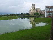
Dong Hwa University

Rice field in Shoufeng - in the background the Haian Mountains


Web link
Individual evidence
- ↑ a b Shoufeng Township Cultural and Historical Museum. East Rift Valley National Scenic Area, accessed May 31, 2018 .
- ↑ 地方 沿革 ("Local History"). Shoufeng Township Web site, accessed May 31, 2018 (Chinese (Taiwan)).
- ↑ 原住民 戶數 及 人數 Households and Persons of Indigenous People. (xls) Taiwan Ministry of the Interior, accessed May 19, 2018 (Chinese / English).
- ^ Liyu (Carp) Lake. taiwan.net.tw, accessed May 31, 2018 .
- ^ Liyu Lake. rtaiwanr.com, accessed May 31, 2018 .
- ↑ Chinan National Forest Recreation Area. taiwan.net.tw, accessed May 31, 2018 .
