
Fengbin
|
Fengbin 豐 濱 鄉 |
|||
.svg) Location of Fengbin in Hualien County |
|||
| State : |
|
||
| County : | Hualien | ||
| Coordinates : | 23 ° 36 ' N , 121 ° 30' E | ||
| Area : | 162.4332 km² | ||
| Residents : | 4,427 (March 2018) | ||
| Population density : | 27 inhabitants per km² | ||
| Time zone : | UTC + 8 (Chungyuan time) | ||
| Telephone code : | (+886) (0) 3 | ||
| Postal code : | 977 | ||
| ISO 3166-2 : | TW-HUA | ||
| Community type : | Rural community ( 鄉 ) | ||
| Structure : | 5 villages ( 村 ) | ||
| Mayor : | Liu Jingfang ( 劉靜芳 ) | ||
| Website : | |||
|
|||

Fengbin ( Chinese 豐 濱 鄉 , Pinyin Fēngbīn Xiāng ) is a rural community in Hualien County in the Republic of China, Taiwan .
description
The municipality of Fengbin consists of an elongated coastal strip with a lengthwise extension in approximately north-northeast direction of about 35 kilometers. The strip of land is on average about 2.5 kilometers wide, with a bulge in the middle section, in which the municipality extends almost 10 kilometers inland. The neighboring communities are Shoufeng in the north and Fenglin , Guangfu , Ruisui and Yuli in the west (from north to south) . To the south, Fengbin borders Changbin Township in neighboring Taitung County . In most sections, the Haian Mountains , which run parallel to the coast, form the natural western boundary. In the southern section, the Xiuguluan River flows into the Pacific. The climate is tropical to subtropical. The annual average temperature is around 24 ° C and varies between 17 ° C in January and 30 ° C in August. The annual precipitation is around 2900 mm. Most of the precipitation is concentrated in the monsoon season from May to October.
history
Human settlement in the area dates back several thousand years. Artifacts of the Neolithic Jomon pottery culture were found in the community. The oldest historically tangible inhabitants of the area are Austronesians , who belonged to different tribes. Beginning around the 19th century, the immigration of Han Chinese gradually began. During the time of the Japanese colonial rule (1895-1945) some Japanese came to the country for a time. After Taiwan was handed over to the Republic of China , Fengbin was organized as a rural community in the newly formed Taitung County.
| Outline of Fengbin |
|
Jiqi
磯 崎 村 Xinshe
新社 村 Fengbin
豐 濱 村 Gankou
港口 村 Jingpu
靜 浦村 |

Administrative division

Fengbin is divided into 5 villages ( 村 , Cūn ): Jiqi ( 磯 崎 村 ), Xinshe ( 新社 村 ), Fengbin ( 豐 濱 村 ), Gankou ( 港口 村 ) and Jingpu ( 靜 浦村 ).
population
According to official statistics, at the end of 2017 there were 3616 people (81%) of the indigenous population . Most of them were Amis and Kavalan .
traffic
The most important traffic artery is the provincial road 11, which runs close to the coast. About halfway up the provincial road 11A (11 wa) branches off in a westerly direction, which crosses the Haian Mountains and connects to the Huatung Valley . From Fengbin it is about an hour's drive to the northern district capital of Hualien .
Sightseeing and tourism
The diverse Pacific coast and the tropical-subtropical vegetation are worth seeing. There are opportunities for nature and sports tourism. Fengbin is in the Tropic of Cancer . A monument was erected here, which is a tourist attraction ( 23 ° 27 ′ 5 ″ N , 121 ° 29 ′ 46.4 ″ E ).
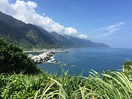
Coastal landscape in the village of Gankou (view in north direction)

Coast road 11 with beach in Jiqi village (view in south direction)


Web links
Individual evidence
- ↑ a b 新社 村 ("Xinshe Village"). Fengbin Township website, accessed May 19, 2018 (Chinese).
- ^ History: Prehistoric Culture. East Coast National Scenic Area, accessed May 19, 2018 .
- ↑ 行政區 介紹 ("Introduction to the administrative districts"). Fengbin Township website, April 20, 2012, accessed May 19, 2018 (Chinese).
- ↑ 原住民 戶數 及 人數 Households and Persons of Indigenous People. (xls) Taiwan Ministry of the Interior, accessed May 19, 2018 (Chinese / English).
- ↑ 交通 指南 ("Traffic Guide"). Fengbin Township website, April 20, 2012, accessed May 19, 2018 (Chinese).
- ↑ Geography: Topography. East Coast National Scenic Area, accessed May 19, 2018 .
- ↑ Ecology: Vegetation. East Coast National Scenic Area, accessed May 19, 2018 .
- ^ Tropic of Cancer Marker. East Coast National Scenic Area, accessed May 19, 2018 .
