
Zhuoxi
|
Zhuoxi 卓 溪鄉 |
|||
.svg) Location of Zhuoxi in Hualien County |
|||
| State : |
|
||
| County : | Hualien | ||
| Founded : | May 1946 | ||
| Coordinates : | 23 ° 23 ' N , 121 ° 11' E | ||
| Area : | 1,021.3130 km² | ||
| Residents : | 6,104 (June 2018) | ||
| Population density : | 6 inhabitants per km² | ||
| Time zone : | UTC + 8 (Chungyuan time) | ||
| Telephone code : | (+886) (0) 3 | ||
| Postal code : | 982 | ||
| ISO 3166-2 : | TW-HUA | ||
| Community type : | Rural community ( 鄉 ) | ||
| Structure : | 6 villages ( 村 ) | ||
| Mayor : | Lu Bixian ( 呂必賢 ) ( KMT ) | ||
| Website : | |||
|
|||

Zhuoxi ( Chinese 卓 溪鄉 , Pinyin Zhuóxī Xiāng ) is a rural community in Hualien County in the Republic of China, Taiwan .
Location and climate
Zhuoxi is located in the interior of the Taiwanese Central Mountains . The topography is largely determined by relatively steep mountain ranges and narrowly cut valleys. There are only a few somewhat larger valley plains in which the sparse human settlements can be found. The neighboring communities are Wanrong in the north, Ruisui , Yuli and Fuli in the west, Haiduan in Taitung County in the south, and the Tauyuan Township of Kaohsiung and Xinyi in Nantou County in the west. The climate in the lower areas is moderately tropical. In contrast, the highest mountain locations have an alpine climate. At the municipal boundary with Xinyi (Nantou) is also the summit of the 3805 m high Xiuguluan Shan ( 秀姑 巒 山 ), the highest mountain in Hualien County.
history
The original inhabitants of the area were Taiwanese Indigenous Austronesians . Due to its inaccessibility, the area remained largely free of Chinese settlement and was only loosely organized administratively during the time of Japanese rule (1895–1945). In May 1946, after the island of Taiwan became part of the Republic of China , the region was reorganized as 'Taiping Municipality' ( 太平鄉 ) and later renamed after the main village 'Zhuoxi'.
| Outline of Zhuoxi |
|
Lunshan
崙 山村 Lishan
立 山村 Taiping
太平村 Zhuoxi
卓溪 村 Zhuoqing
卓 清 村 Gufeng
古風 村 |

administration
Zhuoxi is divided into six villages ( 村 , Cūn ): Lunshan ( 崙 山村 ), Lishan ( 立 山村 ), Taiping ( 太平村 ), Zhuoxi ( 卓溪 村 ), Zhuoqing ( 卓 清 村 ) and Gufeng ( 古風 村 ).
population
According to official statistics, a total of 5,799 people (around 95% of the population) belonged to the indigenous peoples at the end of 2017. Mostly it was bunun .
Agriculture
Typical agricultural products of the municipality are Wendan grapefruit (harvest from August to October), wild green plums ( 野放 青梅 , from late March to late April), camellia oil (September to November) and bamboo shoots (three to four months per year).
Infrastructure
Due to the difficult topography, there are only a few roads. The only major road is Provincial Road 30 from the east.
tourism
Most of the community area is part of the Yushan National Park , which is also a prime tourist destination with its natural attractions.
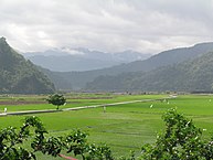
Rice fields on the eastern edge of Zhuoxi
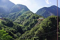
At the start of the Batongguan ( 八 通 關 ) hiking trail
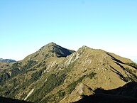
View of the 3496 m high Sanchashan ( 三叉 山 , "three- peak mountain ") on the western edge of Zhuoxi


Web links
Individual evidence
- ↑ 歷史 沿革 ("Historical Development"). Zhuoxi's website, accessed July 7, 2018 (Chinese).
- ↑ 原住民 戶數 及 人數 Households and Persons of Indigenous People. (xls) Taiwan Ministry of the Interior, accessed May 19, 2018 (Chinese / English).
- ↑ 認識 卓溪 (“Get to know Zhuoxi”). Zhuoxi's website, accessed July 7, 2018 (Chinese).
- ↑ 產業 發展 ("Commercial Development"). Retrieved July 7, 2018 (Chinese).
- ↑ Zhuoxi Township.花 東 縱 谷 國家 風景區 (Huatung Valley National Landscape Area), accessed July 7, 2018 (English).
