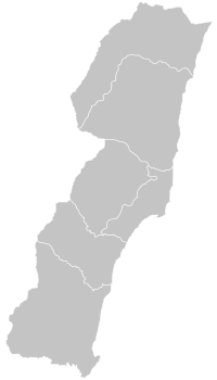
Changbin (Taitung)
|
Changbin 長 濱 鄉 |
||
 Location Changbins, Taitung County |
||
| State : |
|
|
| County : | Taitung | |
| Coordinates : | 23 ° 19 ′ N , 121 ° 27 ′ E | |
| Area : | 155.1868 km² | |
| Residents : | 7,283 (2017) | |
| Population density : | 47 inhabitants per km² | |
| Time zone : | UTC + 8 (Chungyuan time) | |
| Telephone code : | (+886) (0) 89 | |
| Postal code : | 962 | |
| ISO 3166-2 : | TW-TTT | |
| Community type : | Rural community (鄉, Xiāng ) | |
| Structure : | 6 villages (村, Cūn ) | |
|
|
||
Changbin ( Chinese 長濱鄉 , Pinyin Changbin Xiang ) is a rural community in Taitung County on Taiwan ( Republic of China ).
Location and landscape
Changbin is the northernmost community in Taitung County. It consists of an elongated, approximately 8 kilometers wide and 28 kilometers long, north-south stretching coastal strip (the name Changbin means "long coast"). In the north the Tafeng summit marks the end point and in the south the bridge of Chiao. The municipality is bounded inland by the Haian Coast Mountains. The neighboring communities of Changin are Yuli and Fuli (both in Hualien County ) in the west, Fengbin (also Hualien County) in the north, and Chenggong in Taitung County in the south.
| Structure of Changbin |
Administratively, Changbin is further subdivided into the 6 village communities Changyuan (樟 原 村), Sanchien (三 間 村), Chungyung (忠勇 村), Changbin (長 濱 村), Chuhu (竹 湖村), and Ningpu (寧 埔村).
The landscape of Changbin is characterized by a diverse Pacific coast that is well worth seeing. A significant part of the community consists of hills and mountains. The climate is humid, temperate, warm and mild, and ideal for growing rice . From September to March the northeast monsoon blows and between April and September the southwest monsoon, which brings the most rain. The average annual precipitation is up to 2,100 mm. The lowest temperatures are reached in January with an average of around 19 ° C, and the highest temperatures with an average of 28 ° C in July. The region is seismically active. On May 16, 2017, an epicentered earthquake occurred about 60 kilometers off the coast, which was most strongly registered in Changbin with a magnitude of 5.0.
population
The original inhabitants of the area were the indigenous tribes of the Amis and the Kavalan . The immigration of Han Chinese (especially Hakka ) began around the 19th century . Today's population is multiethnic (Amis, Siraya , Kavalan, Bunun , Hakka, Han) and about 80 percent are members of the indigenous peoples of Taiwan . According to the 2010 population statistics, the following languages were spoken at home: 80% standard Chinese , 42% Taiwanese Minnan , 55% indigenous languages , 3% Hakka , 4% other. The majority of the population was multilingual. The population density of Changbins with less than 50 people per km² is extremely low by Taiwanese standards, which is due on the one hand to the hilly topography and on the other hand to the remote location on the east coast.
Economy and Infrastructure
In terms of transport, the area is relatively remote and is far from the major industrial and economic centers of Taiwan, all of which are concentrated in the plains on the west coast. Provincial expressway No. 11 crosses the municipality in a north-south direction. There are no larger industries. Tourism is becoming increasingly important and bicycle tours and bus tours along the east coast of Taiwan are enjoying increasing popularity. The caves and archaeological sites of Baxiandong (八仙洞 遺址), in which Paleolithic human artifacts were found - the oldest finds in all of Taiwan - are of supraregional importance .
Web links
Individual evidence
- ↑ a b c Getting to Know Changbin. Archived from the original on February 2, 2014 ; accessed on October 30, 2017 (English).
- ^ Judy Lin: Magnitude 5.7 earthquake rattles eastern Taiwan. Taiwan News, May 16, 2017, accessed October 30, 2017 .
- ↑ 表 9 臺東縣 6 歲 以上 本 國籍 常住 人口 在家 使用 語言 情形 (“Table 9: Languages spoken at home by people over 6 years of age in Taitung County”). (No longer available online.) Taiwan Bureau of Statistics, archived from original on December 4, 2017 ; Retrieved on December 2, 2017 (Chinese / English, the percentages add up to more than 100%, as a large part of the population is multilingual, the survey did not explicitly ask about the mother tongue, standard Chinese is used as the official language at least as a second language from Majority of the population spoken). Info: The archive link was inserted automatically and has not yet been checked. Please check the original and archive link according to the instructions and then remove this notice.
- ↑ Riding Route. (No longer available online.) Eastcoast-nsa.gov.tw, archived from the original on November 7, 2017 ; accessed on October 30, 2017 (English). Info: The archive link was inserted automatically and has not yet been checked. Please check the original and archive link according to the instructions and then remove this notice.
- ^ Baxian Cave. http://tour.taitung.gov.tw , accessed on October 30, 2017 (English).
- ^ History: Prehistoric Culture. eastcoast-nsa.gov.tw, accessed October 30, 2017 .


