
Donghe (Taitung)
|
Donghe 東 河鄉 |
|||
.svg) Location Donghes in Taitung County |
|||
| State : |
|
||
| County : | Taitung | ||
| Coordinates : | 22 ° 59 ' N , 121 ° 15' E | ||
| Area : | 210.1908 km² | ||
| Residents : | 8,501 (Feb 2018) | ||
| Population density : | 40 inhabitants per km² | ||
| Time zone : | UTC + 8 (Chungyuan time) | ||
| Telephone code : | (+886) (0) 89 | ||
| Postal code : | 959 | ||
| ISO 3166-2 : | TW-TTT | ||
| Community type : | Rural community (鄉, Xiāng ) | ||
| Structure : | 7 villages (村, Cūn ) | ||
| Mayor : | Chen-shi Hong (陳 式 鴻) ( KMT ) | ||
| Website : | |||
|
|||

Donghe ( Chinese 東河鄉 , Pinyin Donghe Xiang , W.-G. Tung 1 ho 2 Hsiang 1 ) is a rural community in Taitung County in Taiwan ( Republic of China ).
Location and geography
The name Donghe (東河) literally means "Eastern River" and alludes to the Mawuku River ( 馬 武 窟 溪 ), which separates Donghe in the northeast from the neighboring community of Chenggong . Donghe has an elongated, approximately spindle-shaped shape with an extension in the north-northeast direction of about 31 kilometers and in the east-southeast direction of a maximum of about 8 kilometers. The neighboring communities are (clockwise from south): Beinan , Yanping , Luye , Guanshan , Chishang , Fuli, and Chenggong, all of which are in Taitung County except for Fuli ( Hualien County ). To the east, Donghe borders the Pacific. The climate is tropical and warm and characterized by the monsoons (see the climate diagrams of Chenggong and Taitung ). Topographically, the municipality consists of a narrow coastal plain that merges further inland into the Haian Mountains , which run parallel to the coast .
| Outline of Donghe |
|
Beiyuan
北 源 村 Taiyuan
泰源 村 Donghe
東 河村 Shangde
尚德 村 Longchang
隆昌 村 Xingchang
興昌 村 Dulan
都 蘭 村 |

Administrative division
Donghe is divided into 7 villages: Beiyuan (北 源 村), Donghe (東 河村), Longchang (隆昌 村), Dulan (or Doulan, 都 蘭 村), Shangde (尚德 村), Taiyuan (泰源 村), Xingchang (興昌 村). The administrative headquarters are in Donghe Village.
population
The community has about 8500 inhabitants. The population density is 40 people per km², well below the Taiwanese average. The majority of the population belongs to the Yanks , one of the indigenous peoples of Taiwan . The predominant language is Amisian .
economy
The main line of business is agriculture. Mainly different types of fruit are grown (citrus fruits, cinnamon apple , atemoya , passion fruit ). The most important traffic arteries are the provincial road 23, which runs along the coast, and the provincial road 11 that branches off and leads inland to Fuli. Tourism is also important. The old bridge over the Mawuku ( 上 的 舊 東 河橋 ), the Pacific coast of Dulan, the "Park of the upward flowing water" ( 水 往上 流 ) in Dulan, the forest recreation area Dulan with the 1190 meter high mountain of the same name (Dulanshan , 都 蘭山 ), u. a. m.

Entrance gate to the village of Dulan, with the Haian Mountains in the background
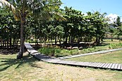
"Upward Flowing Water Park"

View of the Dulanshan from Provincial Road 9


Web links
Individual evidence
- ↑ a b c 交通 指南 ("Traffic Guide"). Donghe Township website, accessed April 28, 2018 (Chinese).
- ^ Agricultural Products. Taitung County website, accessed April 17, 2018 .
- ↑ 台 東 八景 - 東 河橋 遊 憩 區 (Eight Views of Taiwan: Donghe Bridge Recreation Area). Donghe Township website, accessed April 28, 2018 (Chinese).
- ↑ Donghe Bridge. East Coast National Scenic Area, February 8, 2013, accessed April 17, 2018 .
- ^ Water Running Upward - A geographical "miracle". East Coast National Scenic Area, February 8, 2013, accessed April 17, 2018 .
- ↑ Joshua Fryc, Macayla Fryc: Hike Dulan Mountain. theoutbound.com, accessed April 28, 2018 .