Taichung
|
Taichung 臺中市 |
|||
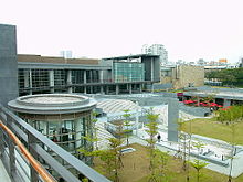
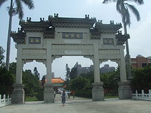
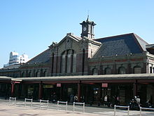
 Business District Skyline, Botanical Garden (Greenhouse) in Northern District, Taichung Railway Station, Luce Memorial Chapel on Tunghai University Campus , Taichung Baseball Stadium, Kaomei Wetland ( Qingshui ) Wind Farm , Nanhu Mountain |
|||
|
|||
| State : |
|
||
| Coordinates : | 24 ° 9 ′ N , 120 ° 40 ′ E | ||
| Area : | 2,214.8968 km² | ||
| Residents : | 2,787,070 (Dec 2017) | ||
| Population density : | 1,258 inhabitants per km² | ||
| Time zone : | UTC + 8 (Chungyuan time) | ||
| Telephone code : | (+886) (0) 4 | ||
| Postal code : | 400-439 | ||
| ISO 3166-2 : | TW-TXG | ||
| Community type : | Government immediate city | ||
| Structure : | 29 districts | ||
| Mayor : | Lu Shiow-yen (盧秀燕) ( KMT ) | ||
| Website : | |||
| City bird: | White-eared timalia | ||
| City flower: | Taiwan cherry | ||
| City tree: | Pinus morrisonicola | ||

|
|||
Taichung ( Chinese 臺中市 / 台中市 , Pinyin Táizhōng Shì , Tongyong Pinyin Táijhōng Shìh , W.-G. T'ai-chung-shih , Zhuyin ㄊ ㄞ ˊ ㄓ ㄨ ㄥ ㄕ ˋ , Pe̍h-ōe-jī Tâi-tiong- chhī - "Central Taiwan City") is a city of millions on the west coast in central Taiwan . It is one of six directly governed cities in the Republic of China and with over 2.7 million inhabitants, it is the third largest city in the country after New Taipei and Kaohsiung . Taichung is the location of the power plant with the world's largest carbon dioxide emissions (36.336 million tons per year; as of 2009).
geography
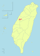
The Taichung area is bounded by Miaoli County in the north and Changhua and Nantou counties in the south. Formosa Road is to the west , and Hsinchu , Yilan and Hualien counties are at the eastern tip .
The coastal plain in the west and the Taichung basin around the core city of Taichung, separated from it by a chain of hills, are densely populated and highly industrialized. The three most populous districts, Fengyuan , Dali and Taiping , which had the status of large cities until 2010, are located in the outskirts of the core city. In the east, the urban area extends far into the impassable Taiwanese central mountains . There the district (until 2010 rural municipality) counting about 11,000 inhabitants (0.4% of the urban population) Heping covers almost half of the urban area.
The district of Heping is part of the Shei-Pa National Park, which is located in the central mountains, and of the Taroko National Park, which extends to the east coast of the island . The Xueshan (雪山), at 3,886 m the second highest mountain in Taiwan, lies on the border with the northern neighboring district Miaoli .
climate
Taichung is said to have the best climate in Taiwan. The weather is relatively mild with a pleasant breeze blowing into the city from the coast. In contrast to the capital Taipei, the number of rainy days is lower and the temperature is less hot than in southern Taiwan. The average temperature is 23.3 ° C, with an average of 1773 mm of precipitation per year.
| Taichung | ||||||||||||||||||||||||||||||||||||||||||||||||
|---|---|---|---|---|---|---|---|---|---|---|---|---|---|---|---|---|---|---|---|---|---|---|---|---|---|---|---|---|---|---|---|---|---|---|---|---|---|---|---|---|---|---|---|---|---|---|---|---|
| Climate diagram | ||||||||||||||||||||||||||||||||||||||||||||||||
| ||||||||||||||||||||||||||||||||||||||||||||||||
|
Climate data from the years 1981–2010
Source: Taiwan Central Weather Bureau
|
||||||||||||||||||||||||||||||||||||||||||||||||||||||||||||||||||||||||||||||||||||||||||||||||||||||||||||||||||||||||||||||||||||||||||||||||||||||
history
The area has been inhabited by humans for more than 4000 years. At the beginning of historical times, native tribes of the western Taiwanese plains lived and hunted here (collective term Pingbuzu 平埔族 ). During the Qing Dynasty , numerous mainland Chinese immigrated from the provinces of Fujian and Canton . At that time, among other things, the place Dadun ( 大墩 ) developed, at that time the most important place in the area. Today Da Dun Street in Taichung commemorates the village.
Under the Japanese occupation of Taiwan from 1895, the place was renamed Taichū ( Japanese 臺中 ). From 1903, the streets in what is now the city center and the city park ( 臺中 公園 ) were laid out. At the beginning of the 20th century Taichung was a stronghold of Taiwanese nationalism, while most schools this time of Japanese were built, which was Taichū Middle School (now the First Municipal Intermediate High School , First Senior High School , TCSFH) founded by Taiwanese with the aim to promote Taiwanese culture. During the Japanese rule in 1920, the island of Taiwan was divided into seven prefectures. One of these was Taichu Prefecture , which comprised today's Taichung and the later districts of Changhua and Nantou .
After World War II , Taiwan became part of the Republic of China . The Japanese administrative units were initially continued, but renamed. The prefecture became Taichung County . The actual urban settlement area remained separate as the urban district Taichung. In 1950 there was a new administrative reform, and the two new counties of Changhua and Nantou were separated from Taichung County. On December 25, 2010, the surrounding Taichung County was dissolved and incorporated into the city. As a result, the population rose from just under 1.1 million to over 2.6 million and the urban area grew from 163 km² to 2215 km². At the same time, Taichung was spun off from Taiwan Province and given the status of a city under the government.
Administrative structure
The city of Taichung, which was enlarged in December 2010, is divided into 29 districts ( 區 , Qū ). Of these, eight districts come from the "core city" (residents and area as of December 2017):
| district | Residents | surface | Population density | |||
|---|---|---|---|---|---|---|

|
km² | Inhabitant / km² | ||||
| Xītún-qū | 西屯 區 | "Western settlement district" | 227.043 | 39.8467 | 5,698 | |
| Běitún-qū | 北屯 區 | "Northern settlement district" | 274.819 | 62.7034 | 4,383 | |
| Nántún-qū | 南屯 區 | "Southern settlement district" | 168,760 | 31.2578 | 5,399 | |
| Běi-qū | 北區 | "Northern District" | 147,653 | 6.9376 | 21,283 | |
| Xī-qū | 西區 | "Western district" | 115,627 | 5,7042 | 20,271 | |
| Zhōng-qū | 中 區 | "Central district" | 18,450 | 0.8803 | 20,959 | |
| Dōng-qū | 東區 | "Eastern District" | 75,811 | 9.2855 | 8,164 | |
| Nán-qū | 南 區 | "Southern district" | 125,067 | 6.8101 | 18,365 |
The remaining 21 districts emerged from the previously independent cities and municipalities of the Taichung district (population December 2017):
| district | chin. | Residents | Area (km²) | Inhabitant / km² | Hanyu Pinyin | Tongyong | Wade-Giles | Taiwanese (POJ) |
|---|---|---|---|---|---|---|---|---|
| Da'an | 大安 區 | 19.303 | 27.4045 | 704 | Dà'ān | Dà-an | Ta-an | Tāi-an |
| Dadu | 大肚 區 | 57,322 | 37.0024 | 1,549 | Dàdù | Dàdù | Ta-tu | Tōa-tō͘ |
| Dajia | 大甲 區 | 77,761 | 58.5192 | 1,329 | Dàjiǎ | Dàjiǎ | Ta-chia | Tāi-kah |
| dali | 大里 區 | 211,492 | 28.8758 | 7,324 | Dàlǐ | Dàlǐ | Ta-li | Tāi-lí |
| Daya | 大雅 區 | 95.203 | 32.4109 | 2,937 | Dàyǎ | Dàyǎ | Ta-ya | Tāi-ngé |
| Dongshi | 東 勢 區 | 50.714 | 117.4065 | 432 | Dōngshì | Dongshìh | Tung-shih | Tang-sì |
| Fengyuan | 豐原 區 | 166,879 | 41.1845 | 4,052 | Fēngyúan | Fongyúan | Feng-yuan | Hong-goân |
| Heping | 和平 區 | 10,949 | 1,037.8192 | 11 | Hépíng | Hépíng | Ho-p'ing | Hô-pêng |
| Houli | 后 里 區 | 54,482 | 58.9439 | 924 | Hòulǐ | Hòulǐ | Hou-li | Aū-lí |
| Longjing | 龍井 區 | 77,818 | 38.0377 | 2,046 | Lóngjǐng | Lóngjǐng | Lung-ching | Liông-chéⁿ |
| Qingshui | 清水 區 | 86,420 | 64.1709 | 1,347 | Qīngshuǐ | Cingshuěi | Ch'ing-shui | Chheng-chui |
| Shalu | 沙鹿 區 | 92,645 | 40.4604 | 2,290 | Shalù | Shalù | Sha-lu | Soa-la̍k |
| Shengang | 神 岡 區 | 65,553 | 35.0445 | 1,871 | Shéngāng | Shéngang | Shen-kang | Sin-kóng |
| Shigang | 石 岡 區 | 15,066 | 18.2105 | 827 | Shigang | Shíhgang | Shih-kang | Chio̍h-kng |
| Taiping | 太平區 | 189,066 | 120.7473 | 1,566 | Tàipíng | Tàipíng | T'ai-p'ing | Thài-pêng |
| Tanzi | 潭子 區 | 108,288 | 25.8497 | 4.189 | Tánzǐ | Tánzǐh | T'an-tzu | Thâm-chú |
| Xinshe | 新 社區 | 24,754 | 68.8874 | 359 | Xīnshè | Sinshè | Hsin-she | Sin-siā |
| Waipu | 外埔 區 | 32,185 | 42.4099 | 759 | Wàipǔ | Wàipǔ | Wai-p'u | Goā-po͘ |
| Wufeng | 霧峰 區 | 65,393 | 98.0779 | 667 | Desire | Wùfong | Wu-feng | Bu-hong |
| Wuqi | 梧 棲 區 | 57,993 | 16.6049 | 3,493 | Wúqī | Wúci | Wu-ch'i | Gō • -chhe |
| Wuri | 烏 日 區 | 74,554 | 43,4032 | 1,718 | Wūrì | Wurìh | Wu-jih | O • -ji̍t |
| Taichung wards |
|---|
|
|
education
There are 11 universities and colleges in Taichung. The three most important universities are Chung Hsing National University ( 國立 中興 大學 ), Feng Chia University ( 逢甲 大學 ) and Tunghai University ( 東海 大學 ), on whose campus the Luce Memorial Chapel by architect Ieoh Ming Pei stands.
economy
Taichung is a center of the global bicycle industry. The world's largest bicycle manufacturer Giant has its headquarters here. Many small and in some cases highly specialized suppliers in the city produce bicycle components that are sold as OEM products worldwide under different names. Well-known companies are the hub manufacturer KT Quando and the brake specialist Tektro.
Attractions
The National Museum of Natural History was opened in 1993 and includes a botanical garden and an Omnimax cinema. The city's art museum is also considered one of the best in Taiwan, but much of the exhibits are traveling exhibitions.
In the city area there are several smaller and larger temples, some of which were built in the 19th century for traditional local folk gods. In addition to Buddhist, Taoist and Mazu temples, there is also a Confucius temple .
There are some night markets in Taichung , the area around Yizhong ( 一 中 街 , Yīzhōng jiē ) is a popular meeting place with many small shops. There are also some larger shopping centers in Taichung.
The Municipal Opera House designed by Japanese architect Toyo Ito was completed in 2014.
The Caihong military settlement was artistically decorated.
traffic
The Highway 1 (Sun Yat-sen Freeway) and the Highway 3 connecting Taichung with other cities on the west coast of Taiwan and Taipei .
Taichung is also connected to the railway line around the island, and all major trains on the north-south connection stop here. The main train station was built in Renaissance style in 1917 during the Japanese control of Taiwan. The main route of the conventional railway branches in the Taichung area into two parallel lines, one of which crosses the former district area in the coastal plain and the other in the Taichung basin.
Taichung is connected to the Taiwan High Speed Rail (HSR). The train station is located south of the center in the Wuri district . The Wuri railway station, which crosses the HSR route there, will also be relocated there. Express HSR trains only stop in Taichung and Banqiao on their way from Taipei to Zuoying / Kaohsiung and back , while ordinary trains also stop in Taoyuan , Hsinchu , Chiayi and Tainan .
The Taichung airport (RMQ) is Taiwan's third largest and newest international airport. It is located about 20 km from the city center and opened in 2004. There are currently domestic connections to Taipei and Hualien, as well as to the Taiwanese islands of Kinmen and the Pescadors ; international connections include Hong Kong and Ho Chi Minh City .
The port Taichung is after the Kaohsiung Harbor largest Situated on the Taiwan Strait Taiwan port.
City symbols
Like many places in Taiwan, Taichung has chosen some living beings as official symbols. "City Bird" which applies Weißohrtimalie ( Heterophasia auricular , one occurring in the forests of Taiwan Songbird白耳畫眉,). It is supposed to symbolize the helpfulness of the Taichung residents. Taichung's “city flower” is the blossom of the Taiwan cherry ( Prunus campanulata , 山 櫻花), a type of cherry tree from the island of Taiwan , which grows at a height of 300 to 2000 meters and has white to pale pink flowers, which are also popular as a motif used for ornamental purposes. The official "city tree" is Pinus morrisonicola , the "five-leaved pine" (五 葉松), a large, decorative conifer that is endemic to Taiwan and is often used in landscape architecture. B. was and is planted in temples, palaces and ornamental gardens. The tree has been a popular motif in Chinese painting since ancient times.
Culinary
Taichung is especially famous for its tea houses . The black pearl milk tea ( 珍珠 奶茶 , Zhēnzhū Nǎichá ), also called bubble tea , comes from Taichung. In addition, the so-called sun cookies ( 太陽 餅 , Tàiyángbǐng ) are a popular souvenir from Taichung.
sons and daughters of the town
- Richard Lin (1933–2011), British painter and sculptor
- Peter Chen (* 1947), US-Taiwanese computer scientist
- David Ho (* 1952), US-Taiwanese AIDS researcher
- Lai Shin-yuan (* 1956), politician
- Lin Chia-ying (* 1982), shot putter
- Chang Ming-huang (* 1982), shot putter and discus thrower
- Hsiao Mei-yu (* 1985), cyclist
- Wu Tung-lin (* 1998), tennis player
Twin cities
Taichung has signed partnership agreements with 23 cities (status: 2018, the annual figures indicate the year of the agreement):
|
|
Web links
- Taichung City (English)
- Taichung city guide
Individual evidence
- ↑ carma.org
- ↑ a b 戶數 、 人口 數 及 遷徙 06 鄉鎮 土地 面積 及 人口 密度 (97) (“Number of households, population and migration: land area and population density of municipalities”). Ministry of Interior Statistics Department, accessed February 3, 2018 (Chinese).
- ↑ Christoph Neidhart: Wheel for the world. In: Süddeutsche Zeitung . July 14, 2017, accessed March 12, 2020 .
- ↑ Toyo Ito's new opera house in Taichung - sound grotto made of foam bubbles. Neue Zürcher Zeitung, June 9, 2015, accessed on June 9, 2015 .
- ↑ Introduction to city bird. Taichung City Government, March 19, 2015, accessed February 3, 2018 .
- ↑ Introduction to city flower. Taichung City Government, March 19, 2015, accessed February 3, 2018 .
- ↑ Introduction to city tree. Taichung City Government, March 19, 2015, accessed February 3, 2018 .


