
Kaohsiung Port
| Kaohsiung Port | |||
|---|---|---|---|
| Data | |||
| UN / LOCODE | TWKHH | ||
| operator | Taiwan International Ports Corporation, Ltd. | ||
| opening | 1858 | ||
| Port type | Commercial port, fishing port, naval base, docking port | ||
| Piers / quays | 123 | ||
| Throughput | 110.9 million tons | ||
| Container (TEU) | 10.2 million TEU | ||
| website | kh.twport.com.tw/chinese/ | ||
| Geographic information | |||
| place | Kaohsiung | ||
| republic | Republic of China (Taiwan) | ||
| Country | Republic of China (Taiwan) | ||
 |
|||
| Coordinates | 22 ° 36 '47 " N , 120 ° 16' 40" E | ||
|
|||

The Kaohsiung Harbor is a seaport in Kaohsiung and one of the four major international ports in Taiwan . The port area extends over six boroughs and cargo handling accounts for more than half of the total cargo handling in Taiwan. Kaohsiung Port is the largest port in the country and the thirteenth largest port in the world. The Taiwan International Ports Corporation (TIPC) is responsible for the administration and operation of Kaohsiung Port .
location
The deep water port is located on an important shipping route between China, Japan, Australia, the USA and Southeast Asia. The port has two entrances: the first is in the north (E 120 ° 15'25 "N 22 ° 37'01") and the second is in the south (E120 ° 18'26 "N 22 ° 33'21"). On the western side of the port is the elongated island of Qijin . It protects the port area in the event of a storm. The port area is home to a coal-fired power station, an oil refinery, shipyards, the Linhai Industrial Area, the Kaohsiung Export Zone, a Logistics Center and the Kaohsiung Free Trade Zone. The port is connected to the railway network via the Kaohsiung Port Railway ( 高雄 臨港 線 ). One of the two railway lines has already been shut down.
history
Ming and Qing dynasties
In the area of today's Kaohsiung there was originally a fishing village of Taiwanese natives . During the Dutch colonial era, the Dutch opened the port of Kaohsiung around 1624. In 1662, General Zheng Chenggong drove the Dutch out of Kaohsiung and expanded the port to finance his war against the Qing Dynasty through trade . In 1863, the port was opened as an international trading port as a result of the Treaty of Tianjin .
Japanese colonial times

After the First Sino-Japanese War , the Qing Dynasty ceded Taiwan and Penghu to Japan in 1895 because of the Treaty of Shimonoseki . From 1899 the Japanese expanded the port of Takao (the city's name at the time) into one of the two main ports on the island of Taiwan (next to the port of Keelung ).
After a four-year construction phase in 1912, a second expansion phase began, which ended in 1937. From this time onwards, ships with a draft of eight meters and a load of 8,000 tons could easily approach the port. The industrial plants in the port were built step by step and the port was connected to the railroad.
In 1924 the port's total trade increased rapidly. At that time, cargo handling reached 1.58 million tons and total trade was over 203 million yen . In 1937, military transport was very important because of the war between China and Japan, and cargo handling reached 2.5 million tons. The port equipment quickly became inadequate, which is why a third expansion phase took place. The construction project was canceled because of the Pacific War in 1941. At that time, the port was used primarily for military purposes by the Japanese army. The Allied air raids, which began on October 12, 1944 and lasted until August 15, 1945, were particularly aimed at the port of Takao. The port's berths, sheds and lifting gear were almost all destroyed.
After the Second World War
The port lost its function due to the war damage. The Kuomintang government established the Taiwan International Ports Corporation in December 1945 and attempts were made to restore the port. Kaohsiung Harbor used to have only one entrance. Due to military and economic needs, a second driveway and an industrial park were opened in 1963. At that time, 17 giant ships of 20,000 tons could moor in this part of the port at the same time. As a result, Kaohsiung Export Zone, Cianjhen Fishing Port, Linhai Industrial Area, a large steel mill, a shipyard, and container terminals 1 to 4 were developed. In May 1981, a four-lane underwater tunnel was built to connect Qijin Island and downtown Kaohsiung. The underwater tunnel was opened on May 1, 1984 for the transport of people and goods. In July 1988, construction of the fifth container terminal began due to the rapidly increasing container throughput. The construction was finished in February 2001 and could handle 49,000 TEU. The Vessel Traffic Service (VTS) and the VTC control tower were completed in late 2011.
On July 1, 2004, the International Ship and Port Facility Security Code was implemented in Kaohsiung Port to prevent terrorist attacks.
Structure and port area

The port area has a total area of 17,678 hectares, of which 1,442 hectares (8.2%) are land and 16,236 hectares (91.8%) are water. The largest areas of the port are the quays, the industrial park and the fishing port, the shipyard, the Taipower power plant, and the CPC ( Chinese Petroleum Corporation ) refinery.
The fairway at the northern entrance is 11 meters deep and between 80 and 130 meters wide. The southern port entrance is 16 meters deep and the fairway is between 150 and 250 meters wide. The total length of the fairways in the port is 18 kilometers, with the main route 12 kilometers and the secondary routes 6 kilometers.
The port has 123 quays with a total length of 28 kilometers. 91 of them are loading quays with 66 hoists, 22 company-owned quays and 10 quays for tourism purposes. A total of 152 ships could dock in the port at the same time. The total throughput amounts to 152 million tons and 14.7 million TEU per year.
The port also has 65 warehouses and warehouses with a total capacity of 969,720 tons. Ten spaces are located outdoors, with a total capacity of 35,284 tons and six container areas with a total capacity of 197,397 TEU.
In 2007, work began on building two elevated roads in the port to connect the motorway with the port. The construction is expected to be completed in 2017.
economy

Bulk handling
The bulk carriers do not make up the majority of the ships visiting Kaohsiung Port, but their loading capacity is the highest. Most of the goods come from Asia, followed by America and Oceania. In 2015, 1,427 bulk carriers carrying 36 million tons of goods visited Kaohsiung Port. Most of the bulk carriers imported goods are metallic ores with 14.38 million tons. In second place comes coal with 10.78 million tons. Most of the exported goods are gasoline (2.52 million tons) and heating oil (1.97 million tons).
| Bulk carrier import | |||
| year | Ships | Ship dimensions (in tons) | Bulk quantity (in tons) |
| 2009 | 1,071 | 29,218,469 | 27.478.202 |
| 2010 | 1,431 | 43.059.243 | 33,309,508 |
| 2011 | 1,526 | 51.257.768 | 35.263.332 |
| 2012 | 1,367 | 45,405,429 | 34,017,464 |
| 2013 | 1,345 | 46,099,721 | 33,638,479 |
| 2014 | 1,449 | 49.160.411 | 38.138.323 |
| 2015 | 1,427 | 49.901.055 | 35.136.456 |
Container handling
In 1969 the first container ship visited Kaohsiung Port. At that time there was no container wharf, so wharf no. 1 was adapted for this purpose. The first container quay was usable in 1970. The other container quays were built step by step. Container throughput increased year after year. In 1995 the container throughput amounted to more than 5 million TEU. In 2000 they were more than 7 million TEU and in 2007 10 million TEU. Most of the goods came from and went to Asia, America and Europe. In 2015, most metals were imported (3.84 million tons), followed by chemical raw materials (1.8 million tons). Most of the exported goods are plastic products with 6.59 million tons. In second place are metals with 4.93 million tons.
| Container handling in Kaohsiung port | |||
| year | TEU total | TEU import | TEU export |
| 2009 | 8,581,273.00 | 4,297,666.50 | 4,283,606.50 |
| 2010 | 9,181,210.50 | 4,557,040.50 | 4,624,170.00 |
| 2011 | 9,636,288.50 | 4,814,254.25 | 4,822,034.25 |
| 2012 | 9,781,221.00 | 4,876,683.75 | 4,904,537.25 |
| 2013 | 9,937,719.00 | 4,982,383.25 | 4,955,335.75 |
| 2014 | 10,593,335.25 | 5,284,335.25 | 5,309,000.00 |
| 2015 | 10,264,420.25 | 5,127,165.25 | 5,137,255.00 |
shipbuilding
The history of shipbuilding began in 1972. In 1973, the China Ship Building Corporation ( CSBC Corporation ) established the shipyard at Quay No. 2. At Quay No. 10, there is a dry dock belonging to TIPC. It is 116 meters long and 19 meters wide. Ships under 6000 tons can be built or repaired there. There are currently 28 shipbuilding companies in Kaohsiung Port. The CSBC shipyard has the largest area with five quays. CSBC's main products are bulk carriers, container ships and warships for the Navy of the Republic of China .
Passenger traffic
Passenger traffic has international lines and domestic lines. The Kaohsiung-Magong Line, Gushan-Qijin Line, and Qianzhen-Zhongzhou Line are the domestic lines. The international routes are operated by cruise lines. The main travel destinations are China, Hong Kong and Japan. Between 2014 and 2015, TIPC built the cruise ship quays, which greatly increased the number of passengers and the number of mooring ships. In 2014 there were 45 ships and 130,000 passengers. In 2015 there were 46 ships and 133,000 passengers. Before 2014 there were an average of 17 ships and 35,000 passengers per year.
| Number of passengers in people | ||||||
| year | Total | International lines | Domestic lines | |||
| Incoming | Outgoing | Incoming | Outgoing | Incoming | Outgoing | |
| 2009 | 54,652 | 63,660 | 2,375 | 2,360 | 52,277 | 61,300 |
| 2010 | 67,490 | 76,743 | 13,384 | 13,911 | 54.106 | 62,832 |
| 2011 | 60,746 | 65,069 | 12,462 | 11,886 | 48.284 | 53,183 |
| 2012 | 58,360 | 61.014 | 16,073 | 14,558 | 42,287 | 46,456 |
| 2013 | 67,865 | 73,254 | 26,252 | 24,168 | 41,613 | 49,086 |
| 2014 | 106,531 | 107,885 | 71,223 | 66,311 | 35,308 | 41,574 |
| 2015 | 99,447 | 107.996 | 63,834 | 64,774 | 35,613 | 43,222 |
gallery

North entrance

South entrance
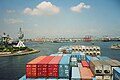
The southern port entrance as seen from a container ship

Entrance to Kaohsiung Port

The Hyundai Freedom container ship in Kaohsiung

Cianjhen fishing port


literature
- You, Ming-Huei: 60-Year Sea Freight Cycle: Kaohsiung Port . Taiwan International Ports Corporation, Ltd, 2007-12, ISBN 978-986-01-1933-6 . 謝明輝. 《海運 軸心 一 甲子: 高雄港: 高雄 港務局 60 週年 專輯》
Web links
Individual evidence
- ↑ Kaohsiung Port's handling volume
- ↑ Container handling in Kaohsiung port
- ↑ Statistical data from the Ministry of Transport
- ↑ Map of Kaohsiung Port
- ↑ a b Home> About us> History. Taiwan International Ports Corporation, Ltd., accessed July 26, 2018 (Chinese).
- ↑ Structure and port area of Kaohsiung Port
- ↑ The fairways in Kaohsiung Harbor
- ↑ The functions of the quays
- ^ Warehouses and warehouses
- ↑ Important construction projects in the port
- ↑ Incoming / outcoming of Harbors: Cargo throughput at International Commercial ports. Ministry of Transportation and Communications of the Republic of China, accessed May 15, 2016 .
- ↑ Kaohsiung Port Report 2015
- ↑ Container handling in Kaohsiung port
- ↑ Shipbuilding
- ↑ number of passengers