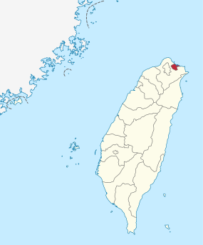
Keelung
|
Keelung 基隆市 |
|||
 View of Keelung Harbor |
|||
|
|||
| State : |
|
||
| County : | District-free city | ||
| Coordinates : | 25 ° 8 ' N , 121 ° 44' E | ||
| Area : | 132.7589 km² | ||
| Residents : | 370,368 (Sep 2018) | ||
| Population density : | 2,790 inhabitants per km² | ||
| Time zone : | UTC + 8 (Chungyuan time) | ||
| Telephone code : | (+886) (0) 2 | ||
| Postal code : | 200-206 | ||
| ISO 3166-2 : | TW-KEE | ||
| Structure : | 7 districts | ||
| Mayor : | Lin Yu-chang ( DPP ) | ||
| Website : | |||
| City bird: | Eagle | ||
| City flower: | Camp currents | ||
| City tree: | Sweetgum trees | ||

|
|||
Keelung (also Jilong or Chilung , Chinese 基隆市 , Pinyin Jīlóng Shì , Zhuyin ㄐ ㄧ ㄌ ㄨ ㄥ ˊ ㄕ ˋ , Pe̍h-ōe-jī Ke-lâng Chhī ) is an independent port city in northeastern Taiwan .
location
Keelung is located on the north coast of the island of Taiwan. The city has the largest natural harbor in northern Taiwan and the port extends into the city center. The city is surrounded by mountains and therefore has little hinterland. Today Keelung is divided into seven districts. The city area also includes seven islands: Heping Dao (和平 島), Zhongshan Tsai Dao (中山 仔 嶼), Tongpan Yu (桶 盤 嶼), Jilong Yu (基隆 嶼), Pengjia Yu (彭佳 嶼), Mianhua Yu (棉花嶼) and Huaping Yu (花瓶 嶼). The first three are now connected by bridges and are also known together as Heping Dao . Both the districts and the islands each have their own character.
history
Keelung is of particular historical importance as the Spaniards first built a fortified settlement here in Taiwan in 1626 (San Salvador). Three years later they built a second fort in Tamsui (Fort Santo Domingo). In 1642 the Spaniards withdrew from Taiwan after a long siege by the Dutch after they had given up Fort Santo Domingo a few years earlier. The Dutch, in turn, fled Keelung after Koxinga (Zheng Chenggong) had conquered the Dutch branch in Tainan in southern Taiwan . They returned two years later, but finally gave up the base in 1668 because trade with China did not bring the hoped-for profits.
During the reign of the Qing Dynasty, Keelung began to develop increasingly from around the year 1800. The economic development was based on the one hand on the good natural harbor, the gold extraction from the river Keelung and later the exploitation of the newly discovered high-quality coal deposits.
During the Sino-French War , Keelung was occupied by French troops under General Jacques Duchesne from October 1, 1884 to June 22, 1885 .
During the time when Taiwan was under Japanese rule , the city name was also read Kiirun . During the Pacific War , the city and port were targeted by American air strikes.
present
Today Keelung is a relatively modern city with around 370,000 inhabitants (2014). The city has the second most important port in Taiwan, which is also a deep water port. The night market is comparatively famous .
climate
The climate is subtropical and warm and very rainy.
| Keelung | ||||||||||||||||||||||||||||||||||||||||||||||||
|---|---|---|---|---|---|---|---|---|---|---|---|---|---|---|---|---|---|---|---|---|---|---|---|---|---|---|---|---|---|---|---|---|---|---|---|---|---|---|---|---|---|---|---|---|---|---|---|---|
| Climate diagram | ||||||||||||||||||||||||||||||||||||||||||||||||
| ||||||||||||||||||||||||||||||||||||||||||||||||
|
Climate data from the years 1981–2010
Source: Taiwan Central Weather Bureau
|
||||||||||||||||||||||||||||||||||||||||||||||||||||||||||||||||||||||||||||||||||||||||||||||||||||||||||||||||||||||||||||||||||||||||||||||||||||||
Administrative structure
Keelung is divided into seven districts ( 區 , Qu ):
| District | Inhabitants (Sep. 2018) |
Area (km²) |
||
|---|---|---|---|---|

|
Zhongzheng | 中正 區 | 51,734 | 10.2118 |
| Zhongshan | 中 山區 | 47,460 | 10.5238 | |
| Ren'ai | 仁愛 區 | 43,970 | 4.2335 | |
| Xinyi | 信義 區 | 52,463 | 10.6706 | |
| Lean | 安樂 區 | 82,269 | 18.0250 | |
| Nuannuan | 暖暖 區 | 38,630 | 22.8283 | |
| Qidu | 七堵 區 | 53,842 | 56.2659 | |
City symbols
Keelung's coat of arms consists of a blue ring with an opening towards the top, with stylized green mountain peaks in the center of the circle. The opening of the circle should symbolize the port exit and the green peaks the hilly surrounding area of Keelung. In the foreground are the two characters of the city's name 基隆 , which are designed to be reminiscent of a container ship. There is a separate city anthem ( 基隆市 市 歌 - "City Anthem of the City of Keelung"), which praises the landscape and the prosperity of the city. The official city tree is the Formosa sweetgum tree ( Liquidambar formosana ), the official city flower is the Chinese Lagerströmie ( Lagerstroemia indica ), the official city bird is the eagle and the city fish is the sea bream Acanthopagrus schlegelii .
Web links
Individual evidence
- ^ Geography. Keelung website, accessed June 12, 2020 .
- ↑ a b History. Keelung website, accessed June 12, 2020 .
- ↑ 台湾 省 基隆市 KEELUNG City, TAIWAN Province. anthems.lidicity.com, accessed June 12, 2020 (Traditional Chinese).
- ↑ Something about Keelung. Keelung website, accessed June 12, 2020 .


