Lean
|
Anle 安樂 區 |
||
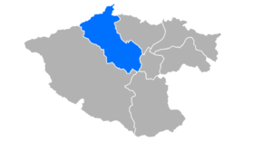
 Location Anles in Keelung |
||
| State : |
|
|
| Coordinates : | 25 ° 9 ' N , 121 ° 42' E | |
| Area : | 18.0250 km² | |
| Residents : | 82,269 (September 2018) | |
| Population density : | 4,564 inhabitants per km² | |
| Time zone : | UTC + 8 (Chungyuan time) | |
| Telephone code : | (+886) (0) 2 | |
| Postal code : | 204 | |
| ISO 3166-2 : | TW-KEE | |
| Community type : | Municipality of Keelung | |
| Website : | ||
|
|
||
Anle ( Chinese 安樂 區 , Pinyin Ānlè Qū , Pe̍h-ōe-jī An-lo̍k Khu ) is a district of the northern Taiwanese port city of Keelung .
Location and importance
Anle is the most populous district of the city of Keelung and owes its development to its proximity to the port of Keelung . Located in the north on the East China Sea , the district is bordered by the neighboring districts of Zhongshan , Ren'ai and Nuannuan to the east and southeast and by the district of Qidu and the city of New Taipei to the south and west . Many commuters live in Anle and work in the port districts and in the city center. The district is connected to Autobahn 1 and Autobahn 3 . Historical sights include the fishing village of Aodi and Fort Dawulun . A popular destination is the Qingren Lake .
history
The nucleus of today's district was the fishing village of Aodi, founded by Chinese immigrants in the 18th century . In the 19th century, the Chinese Empire built a fort on the hill Dawulun to defend the north coast of Taiwan , which successfully held its own against the French invading forces during the occupation of Keelung in the Sino-French War in 1884. In the 20th century, the city center of Keelung expanded due to the increasing importance of the port, which led to a rapid increase in the population of Anles.


