
Qijin
|
Qijin 旗津 區 |
|||
.svg) Location of Qijin in the Kaohsiung city area |
|||
| State : |
|
||
| Coordinates : | 22 ° 34 ' N , 120 ° 18' E | ||
| Area : | 1.4639 km² | ||
| Residents : | 28,763 (Dec 2017) | ||
| Population density : | 19,648 inhabitants per km² | ||
| Time zone : | UTC + 8 (Chungyuan time) | ||
| Telephone code : | (+886) (0) 7 | ||
| Postal code : | 805 | ||
| ISO 3166-2 : | TW-KHH | ||
| Community type : | Municipality of Kaohsiung | ||
| Structure : | 13 districts ( 里 ) | ||
| Website : | |||
|
|||

The island of Qijin , also Cijin ( Chinese 旗津 區 , Pinyin Qíjīn Qū , Tongyong Pinyin Cíjin Cyu , Pe̍h-ōe-jī Kî-tin khu ) is a district of the city of Kaohsiung in Taiwan . Large stretches of Kaohsiung Harbor lie between the island and the city center. Historically a nucleus of the later city, the island is now also an important tourist destination for the residents of Kaohsiung as well as for guests from outside. The population of Qijin was 29,468 in December 2012.
Location and traffic
Qijin lies in front of the city of Kaohsiung in the southwest. Apart from the elevated northern tip, a former coral reef , the rest of Qijins emerged from a sandbank off the coast and is therefore very shallow. The approximately 8.5 km long and an average of 400 m wide island runs from northwest to southeast almost parallel to the districts of Gushan , Yancheng , Qianzhen and Xiaogang . Large sections of Kaohsiung Harbor lie between the island and the opposite bank and there is heavy shipping traffic. The Taiwan Strait stretches to the west of the island .
At the northern tip, Qijin is only 130 m from the other bank. This point forms the northern port entrance of Kaohsiung. At this point is also the highest point on the island at 48 m, on which there is a lighthouse. A little below the harbor entrance there is a ferry service between Qijin and the Gushan district. At the southern end, the shortest distance to the opposite bank is about 400 m. Here the island is connected to the Xiaogang district by an underwater tunnel for motor vehicles.
history
Qijin was originally a peninsula and connected to the opposite side of the city at the southern tip. In earlier times only occasional landing stage for fishermen, traders or pirates, Qijin was only permanently settled from mainland China and provided with a permanent port during the time of the Dutch rule over Taiwan (1624–1662). This settlement formed the nucleus of the later city of Kaohsiung.

The port continued to grow in importance in the following centuries. At the time of the Qing Dynasty , the peninsula was called Qihou (Chinese 旗 後 or 旗 后, literally: “lying behind the flag”) because the hill in the north (Chinese 旗山Qíshān , literally “flag mountain”) is called a on the flat rest of the peninsula compared to the "planted" flag. In 1883 the first lighthouse was built on the hill, which was replaced by a more modern one between 1916 and 1918 by the Japanese colonial rulers . The peninsula received its current name under the Japanese.
Qijin remained the most populous part of Kaohsiung for a long time, but with the increasing industrialization of the hinterland during Japanese rule and the period after World War II, the focus of Kaohsiung shifted more and more inland. In today's megacity, Qijin is one of the districts with the smallest population. Some of the inhabitants are still employed in the port industry and fishing, but in recent times tourism has been rapidly increasing in importance as a source of income.
The southern land connection between Qijin and the rest of the city was demolished in 1967 to create an additional entrance for the port of Kaohsiung. Only since then has Qijin been a real island.
tourism

Qijin is now one of the most popular destinations for Kaohsiung citizens and foreign guests. The most famous attractions are a native of the Japanese colonial period 11m high lighthouse on the northern tip and built in 1673 the Tianhou Gong (popularly Mazu miao called "Mazutempel"), one of the Taoist goddess Mazu sacred temple , where the 1673 by the The wooden figure of the goddess brought along by the first Chinese settlers from Fujian can be seen.
Other attractions of the island include the sunsets that can be observed here, the view from the lighthouse of the city on the opposite side and the Taiwan Strait with the ships passing through it, a tunnel leading through the northern hill to the port entrance and newly constructed tunnels Bicycle and walking paths along the western promenade. In the northwest there is a small sandy beach with bathing facilities. The main shopping street, which leads from the ferry terminal to the beach, has a large number of stalls, food stalls and a few restaurants. Above all, seafood of all kinds is offered here.
Islands in the South China Sea
Some islands and a reef in the South China Sea that are controlled by the Republic of China (Taiwan) are administratively part of Qijin District, namely the Dongsha Islands , Taiping Dao, and the Zhongzhou Reef .
gallery


Qijin Harbor Entrance and Lighthouse as seen from the Gushan District opposite

View of the northwest side with the beach

View of Qijin at night with Kaohsiung City in the background

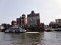
Ferry to Qijin

The ferry dock
Ferry and pier


Web links
- Qijin District Official Website
- Kaohsiung City Tourist Office website
- Website of the Mazu Temple on Qijin
Individual evidence
- ↑ Population statistics of the city administration (chin.)
- ↑ History of Qijins (chin.) ( Memento of the original from October 14, 2011 in the Internet Archive ) Info: The archive link was inserted automatically and has not yet been checked. Please check the original and archive link according to the instructions and then remove this notice.
- ↑ History of the Mazu Temple on Qijin ( Memento of the original from July 9, 2013 in the Internet Archive ) Info: The archive link was inserted automatically and has not yet been checked. Please check the original and archive link according to the instructions and then remove this notice.

Core city: Nanzi | Zuoying | Gushan | Sanmin | Yancheng | Qianjin | Xinxing | Lingya | Qianzhen | Qijin | Xiaogang
Outer city: Fengshan | Daliao | Niaosong | Linyuan | Renwu | Dashu | Dashe | Gangshan | Luzhu | Qiaotou | Ziguan | Mituo | Yong'an | Yanchao | Tianliao | Alian | Qieding | Hunei | Qishan | Meinong | Neimen | Shanlin | Jiaxian | Liugui