
Jiaxian
|
Jiaxian 甲仙 區 |
|||
.svg) Location of Jiaxian District in Kaohsiung |
|||
| State : |
|
||
| Coordinates : | 23 ° 5 ' N , 120 ° 35' E | ||
| Area : | 124.0340 km² | ||
| Residents : | 6,079 (Feb. 2018) | ||
| Population density : | 49 inhabitants per km² | ||
| Time zone : | UTC + 8 (Chungyuan time) | ||
| Telephone code : | (+886) (0) 7 | ||
| Postal code : | 847 | ||
| ISO 3166-2 : | TW-KHH | ||
| Community type : | Municipality of Kaohsiung | ||
| Structure : | 7 districts (里) | ||
| Website : | |||
|
|||

Jiaxian or Jiasian ( Chinese 甲仙 區 , Pinyin Jiǎxiān Qū , Tongyong Pinyin Jiǎsian Cyu , W.-G. Chia 3 -hsien 1 Ch'ü 1 ) is a municipality of Kaohsiung in the Republic of China (Taiwan) .
Location, geography and climate
Jiaxian is located in the rural, mountainous northeast of the urban area of Kaohsiung. The municipality borders in the north on the municipality of Namaxia . The southwestern foothills of the Yushan Mountains form the border with the municipalities of Tauyuan and Liugui in the east. In the west, the Dawushan and Neiwushan mountain ranges form the border with the Nanhua district of Tainan . Neighboring to the south is the Shanlin District (also Kaohsiung). The district measures 5.3 kilometers from east to west and 22.61 kilometers from northeast to southwest. The whole length of the district is traversed by the Qishan River (旗山溪, other name: Nanzixian, 楠梓仙溪).
history
The original inhabitants of the region were members of the indigenous peoples of Taiwan . According to tradition, the first Han Chinese settlers came to the area during the reign of Emperor Qianlong (1735–1796). However, due to its remoteness, the region remained sparsely populated and for the most part was only nominally under the control of the Chinese administration. This changed after the annexation of Taiwan by Japan in 1895. The Japanese administration brought the entire island under control by military and police means. The Jiaxian area was of economic interest because of its extensive camphor tree populations. From 1920 it was called 'Jiaxian'. After 1945, the area became a rural community (鄉, Xiāng ) part of Kaohsiung County and when it was incorporated into Kaohsiung City on December 25, 2010, Jiaxian became a municipality (區, Qū ) of Kaohsiung.
Xiaolin natural disaster in 2009
Jiaxian District (then still a rural community) was badly hit by Typhoon Morakot in August 2009. On the morning of August 9, 2009, shortly after 6:00 a.m. local time, an extensive landslide over a length of 3.2 kilometers in an east-west direction occurred in the village (村, today district, 里) Xiaolin (小林 村) a width of 0.8 to 1.5 kilometers. Previously there had been massive rainfall for three days and the cumulative rainfall was 1676 mm. The landslide dammed the Qishan River, which was swollen from the rains. About 1 1 ⁄ 2 hours later the dam broke and a tidal wave was created that moved downstream at high speed. In the Xiaolin settlement 27.8 kilometers downstream, the water level initially fell by 2.75 meters between 7:10 and 7:50 a.m. and a short time later it rose by 7.88 meters between 8:40 and 9 a.m. : 30 o'clock measured. 400 people died or remained missing as a result of the flood and mud waves. The Xiaolin settlement no longer exists (but the administrative unit of the same name).
population
The population of Jiaxian is around 6,000. This makes Jiaxian one of the most sparsely populated districts of Kaohsiung. Part of the population belongs to the indigenous peoples of Taiwan (including Taivoan ). A significant percentage of the population belongs to the Hakka minority .
| Outline of Jiaxians |
|
Xiaolin
小林 里 Guanshan
關 山里 He'an
和 安 里 Dongan
東 安 里 Xi'an
西安 里 Datian
大 田里 Baolong
寶隆 里 |

Administrative division
Jiaxian is further subdivided into 7 districts (里, Li ): Xiaolin (小林 里), Guanshan (關 山里), He'an (和 安 里), Dongan (東 安 里), Xi'an (西安 里), Datian (大田里) and Baolong (寶隆 里).
economy
The two main industries are agriculture and tourism. Agricultural products of the region are taro , bamboo shoots and plums. The district is particularly known for the taro produced here.
Attractions
Jiaxian has a cemetery from 1886, from the Qing Dynasty. Soldiers who died while building a road are buried here. The cemetery has been designated a "Historic Site" by the Kaohsiung City Council.
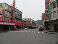
Street scene in Jiaxian 
Xiaolin's remains (August 2009) 
Xiaolin in 2016


Web links
Individual evidence
- ^ Geography. Kaohsiung City Council, accessed March 31, 2018 .
- ^ History. Kaohsiung City Council, accessed March 31, 2018 .
- ↑ Ching-Ying Tsou, Zheng-Yi Feng, Masahiro Chigira: Catastrophic landslide induced by Typhoon Morakot, Shiaolin, Taiwan . tape 127 , no. 3–4 , April 15, 2011, pp. 166–178 , doi : 10.1016 / j.geomorph.2010.12.013 (English, online [PDF]).
- ^ Distribution of the Hakka Population in Taiwan. Hakka Affairs Council, February 25, 2011, accessed March 31, 2018 .
- ↑ Jiaxian to celebrate rebirth after Typhoon Morakot. Taiwan Today, June 24, 2010; accessed March 31, 2018 .
- ↑ Historic Sites: Jiasian Jhenhai Military Cemetery. Kaohsiung City Council, accessed April 1, 2018 .

Core city: Nanzi | Zuoying | Gushan | Sanmin | Yancheng | Qianjin | Xinxing | Lingya | Qianzhen | Qijin | Xiaogang
Outer city: Fengshan | Daliao | Niaosong | Linyuan | Renwu | Dashu | Dashe | Gangshan | Luzhu | Qiaotou | Ziguan | Mituo | Yong'an | Yanchao | Tianliao | Alian | Qieding | Hunei | Qishan | Meinong | Neimen | Shanlin | Jiaxian | Liugui