
Liugui
|
Liugui 六 龜 區 |
|||
.svg) Location of the Liugui District in Kaohsiung |
|||
| State : |
|
||
| Coordinates : | 22 ° 58 ' N , 120 ° 39' E | ||
| Area : | 194.1584 km² | ||
| Residents : | 12,989 (Sept. 2018) | ||
| Population density : | 67 inhabitants per km² | ||
| Time zone : | UTC + 8 (Chungyuan time) | ||
| Telephone code : | (+886) (0) 7 | ||
| Postal code : | 844 | ||
| ISO 3166-2 : | TW-KHH | ||
| Community type : | Municipality of Kaohsiung | ||
| Structure : | 12 districts ( 里 ) | ||
| Mayor : | Song Guilong ( 宋貴龍 ) | ||
| Website : | |||
|
|||

Liugui , also Liouguei , ( Chinese 六 龜 區 , Tongyong Pinyin Liòuguei Cyu , W.-G. Liu 4 -kuei 1 Ch'ü 1 ) is a municipality of Kaohsiung in the Republic of China (Taiwan) .
Location, geography
Liugui is located in the mountainous interior of Taiwan and is comparatively sparsely populated. The neighboring districts are Tauyuan in the northeast, Maolin in the southeast, and in the west the districts (from north to south) Jiaxian , Shanlin and Meinong . To the south, the district borders the Gaoshu Township of Pingtung County . The community forms an elongated strip of land that encloses the valley of the Laonong River ( 荖 濃 溪 ). In its maximum longitudinal extent it measures almost 31 kilometers and the width varies between about 3.7 and 8 kilometers. In the valley floor there is a hot, rainy tropical monsoon climate with an average annual rainfall of around 2000 mm. The average annual temperature is around 23 ° C. Temperatures are more moderate at higher altitudes.
history
The original inhabitants were Taiwanese Austronesians , most recently mostly Bunun people. From around the 19th century onward, Han Chinese began to immigrate , which intensified under Japanese colonial rule. After the island of Taiwan was handed over to the Republic of China in 1945, the area was organized as the Liugui Municipality. The origin of the name 'Liugui' ( 六 龜 ), literally “six turtles ”, has not been clarified with certainty. On the one hand, it is believed that it derives from the indigenous local name Lakuri , on the other hand there is the theory that the name originated from turtle-like shaped hills. Liugui became a rural community ( 鄉 , Xiāng ) in the newly formed Kaohsiung County . The division into villages has been changed several times over the years. When the county was incorporated into Kaohsiung City on December 25, 2010, Liugui was given the status of a borough ( 區 , Qū ).
| Outline Liuguis |
|
Baolai
寶來 里 Laonong
荖 濃 里 Xinfa
新 發 里 Liugui
六 龜 里 Xinglong
興 龍 里 Yibao
義 寶 里 →
Wenwu
文武 里 Zhongxing
中興 里 Dajin
大 津 里 Xinxing
新興 里 Xinwei
新 威 里 Xinliao
新寮 里 |

Administrative division
Liugui is divided into 12 districts ( 里 , Li ): Baolai ( 寶來 里 ), Laonong ( 荖 濃 里 ), Xinfa ( 新 發 里 ), Liugui ( 六 龜 里 ), Xinglong ( 興 龍 里 ), Yibao ( 義寶 里 ), Wenwu ( 文武 里 ), Zhongxing ( 中興 里 ), Dajin ( 大 津 里 ), Xinxing ( 新興 里 ), Xinwei ( 新 威 里 ), Xinliao ( 新寮 里 ).
population
According to an official survey, a total of 542 people (around 4%) belonged to the indigenous peoples at the end of 2017.
Agriculture
Typical local agricultural products include mango , papaya , plum , Japanese plum , Java apple , Chinese jujube , wild camellia ( 野生 山茶 ), and black pepper .
Infrastructure
The most important road is Provincial Road 27, which runs parallel to the Laonong River on the east bank, roughly in a north-south direction. Provincial road 27A (27 甲 ) branches off near the village of Xinglong , crosses the river and goes south on the other bank of the river, where it then meets provincial road 28, which runs in an east-west direction, which is also a cross connection between the provincial roads 27 and 27A.
Attractions
The main attraction of Liugui are the natural sights. Several bridges cross the Laonong river valley and offer scenic viewpoints, such as the Xinwei Bridge ( 新 威 大橋 ) in the south ( ), the Dongxi Bridge ( 東溪 大橋 ) in the middle section ( ) and the Xinfa Bridge ( 新 發 大橋 ) further north ( ).
![]()
![]()
![]()
In the butterfly valley ( 彩蝶 谷 , ), which covers more than 400 hectares, more than 250 species of tropical butterflies can be observed in the months of May and June. In Forest Park or the nursery Xinwei ( 新威森林公園 , 新威苗圃 , ) various tropical tree species, including growing mahogany . The Shiba Luohanshan ( 十八 羅漢 山 , "Mountain of the Eighteen Luohans" or "Mountain of the Eighteen Arhats " ) is also worth seeing . The name comes from the peculiar shape of the 18 mountain hills, which are supposed to be reminiscent of 18 crouching Buddhist students. The tunnels under Mount 18 Arhat have also become a tourist attraction. The 6 tunnels with a total length of 782 meters were built during the Japanese rule in the 1930s to facilitate the removal of camphor and wood. Various birds and bat species have nested here since it was closed in 1992.
![]()
![]()
![]()
There are several small Buddhist temples in Liugui, including the Miaochong Temple ( 清涼山 護 國 妙 崇 寺 , ), the Diyuan Temple ( 諦 願 寺 , ) and the Miaotong Temple ( 妙 通 寺 , ).
![]()
![]()
![]()

Laonong river valley
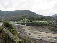
Xinfa Bridge on Provincial Road 27
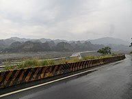
"18 Arhat Mountain"


Sons and Daughters of the Borough
- Hsiang Chun-hsien (* 1993), high jumper
Web links
- Liugui District , Maolin National Landscape Area (English, list of sights)
Individual evidence
- ↑ a b 認識 六 龜 - 基本 資料 (“Get to know Liugui - Basic information”). (No longer available online.) Liugui's website, archived from the original on June 12, 2018 ; Retrieved October 26, 2018 (Chinese). Info: The archive link was inserted automatically and has not yet been checked. Please check the original and archive link according to the instructions and then remove this notice.
- ↑ 原住民 戶數 及 人數 Households and Persons of Indigenous People. (xls) Taiwan Ministry of the Interior, accessed May 19, 2018 (Chinese / English).
- ↑ 時令 物產 (“Seasonal Products”). Liugui's website, accessed October 26, 2018 (Chinese).
- ↑ Xinwei Scenic Bridge. Maolin National Landscape Area, accessed October 29, 2018 .
- ↑ Liugui Dongxi Bridge. Maolin National Landscape Area, accessed October 29, 2018 .
- ↑ Colorful Butterfly Valley. Maolin National Landscape Area, accessed October 29, 2018 .
- ↑ 彩蝶 谷 風景 特定 區 ("Butterfly Valley Landscape Area"). Liugui's website, accessed October 29, 2018 (Chinese).
- ↑ Sinwei Forest Ecological Park (Sinwei Nursery Garden). Liugui's website, accessed October 29, 2018 (Chinese).
- ↑ Shihba Luohanshan. Maolin National Landscape Area, accessed October 29, 2018 .
- ↑ Liouguei tunnels prove popular visitor attraction. Taipei Times, February 16, 2018, accessed October 28, 2018 .
- ↑ Renée Salmonsen: Abandoned tunnels in Kaohsiung, Taiwan turned into eco-habitat. Taiwan News, February 16, 2018, accessed October 28, 2018 .
- ↑ Diyuan Temple. Maolin National Landscape Area, accessed October 29, 2018 .
- ↑ Miaotong Temple. Maolin National Landscape Area, accessed October 29, 2018 .

Core city: Nanzi | Zuoying | Gushan | Sanmin | Yancheng | Qianjin | Xinxing | Lingya | Qianzhen | Qijin | Xiaogang
Outer city: Fengshan | Daliao | Niaosong | Linyuan | Renwu | Dashu | Dashe | Gangshan | Luzhu | Qiaotou | Ziguan | Mituo | Yong'an | Yanchao | Tianliao | Alian | Qieding | Hunei | Qishan | Meinong | Neimen | Shanlin | Jiaxian | Liugui