Hurdegaryp
 flag |
 coat of arms |
| province |
|
| local community |
|
|
Area - land - water |
10.58 km 2 10.39 km 2 0.19 km 2 |
| Residents | 4,795 (Jan 1, 2017) |
| Coordinates | 53 ° 13 ' N , 5 ° 56' E |
| Important traffic route |
|
| prefix | 0511 |
| Postcodes | 7203, 8921, 8932, 9251, 9254-9257, 9269 |
| Website | Homepage of Hurdegaryp |
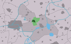
| Location of Hurdegaryp in the municipality of Tytsjerksteradiel | |
Hurdegaryp ( Dutch Hardegarijp ) is a Dutch town with around 4,795 inhabitants (as of January 1, 2017). It belongs to the municipality of Tytsjerksteradiel . The village has a stop on the Leeuwarden – Groningen railway line .
The name may mean "hard land on a narrow strip of land" in Frisian. The subsoil actually consists of sandy soils. Hurdegaryp was first mentioned in the 13th century.
Web links
Commons : Hurdegaryp - collection of images, videos and audio files
- Place website (Dutch)
Individual evidence
- ↑ a b Kerncijfers wijken en buurten 2017 Centraal Bureau voor de Statistiek , accessed on June 20, 2018 (Dutch)

