Hurman Kalesi
| Hurman Kalesi | ||
|---|---|---|
|
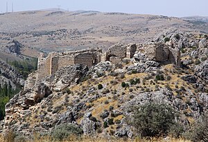
Hurman Kalesi from the southeast |
||
| Alternative name (s): | Hisn el-Rummân, Romaina | |
| Creation time : | Byzantine Empire | |
| Castle type : | Hilltop castle | |
| Conservation status: | ruin | |
| Construction: | Ashlar | |
| Geographical location | 38 ° 28 '29.1 " N , 36 ° 50' 8.7" E | |
| Height: | 1310 m | |
|
|
||
Hurman Kalesi is a Byzantine - Seljuk fortress in southern central Turkey . At times it was the dominant castle of the Byzantine theme of Lycandus .
location
The castle is located in the Afşin district of the Turkish province of Kahramanmaraş , about 25 kilometers north of Afşin and 100 kilometers north of the provincial capital Kahramanmaraş , above the valley of the Hurman Çayı. Already in ancient times this was an important traffic route with the road following its course, which connected Cappadocia in the west via the mountain ranges of the Dibek and the Binboğa Dağları with southeastern Anatolia and Syria . It flows south of the castle through the plain of Elbistan , where it flows into the Ceyhan , which gave the fortress a strategic key position over the plain.
history
The construction date of the castle is not known, it is believed that it was built in Byzantine times, and coin finds even date back to Roman times . In the 10th century it was in the contested border area between the Byzantine Empire and the Arabs ( al-ʿAwāsim ). After it was recaptured by the Armenian Melias for Byzantium, the castle was re-fortified in 911 and became the main castle of the Lykandos theme founded in 916. When the Seljuks ruled the region from the 12th century onwards, the castle was fundamentally rebuilt so that most of the components that are visible today date from this period. Under Ottoman rule, the fortress was rebuilt again in the 17th and 18th centuries. In Byzantine times the fortress was named Romaina, the Arabic name was Hisn ar-Rummān.
construction
The castle is located on a rock sloping to the southwest towards the river and has an approximately rectangular floor plan of around 80 × 50 meters. The extensive walls made of large, multi-colored ashlar blocks have been preserved, some of which are over ten meters high. The walls contain eight bastions . The main entrance was in the west, where probably the village of Sobagena , which belonged to the castle, was also located. Behind the entrance a second wall with another gate was built in Seljuk times. The east side also had an entrance. From the buildings inside the castle only remains of the foundations can be seen, the functions of which can no longer be interpreted.
literature
- TA Sinclair: Eastern Turkey: An Architectural and Archaeological Survey, Volume II , London 1989, ISBN 978-0-907132-33-2 . Pp. 489-492.
Web links
- Afşin Hurman Kalesi Tarihi (Turkish)
Individual evidence
- ^ TA Sinclair: Eastern Turkey: An Architectural and Archaeological Survey, Volume II , London 1989, ISBN 978-0-907132-33-2 . P. 512.
- ^ Anatolic index
- ^ TA Sinclair: Eastern Turkey: An Architectural and Archaeological Survey, Volume II , London 1989, ISBN 978-0-907132-33-2 . P. 508.


