Hurricane Dora (1964)
| Category 4 hurricane ( SSHWS ) | ||
|---|---|---|
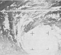
| Satellite image of Dora on September 5th | ||
| Emergence | August 28, 1964 | |
| resolution | September 14, 1964 | |
|
Peak wind speed |
|
|
| Lowest air pressure | 942 mbar ( hPa ; 27.8 inHg ) | |
| dead | 5 in total | |
| Property damage | $ 280 million (1964) | |
|
Affected areas |
Bahamas , east coast of the United States (especially Florida ), Atlantic Canada | |
| Season overview: 1964 Atlantic hurricane season |
||
Hurricane Dora was a tropical cyclone that caused enormous damage in September 1964 in the Bahamas, and particularly in the northern part of Florida . The hurricane , which temporarily hit Category 4 , was the first recorded to hit the First Coast with hurricane strength. The storm formed on August 28th on the Senegalese coast as a tropical wave .
Storm course
Hurricane Dora was identified as a broad, low-pressure region on August 28 as it moved over the west coast of Africa near Dakar to the Atlantic Ocean. Moving west-southwest, the low pressure area grazed the Cape Verde Islands on the following day. On August 31, images from TIROS VIII showed a developing storm with eyes and rainy foothills, ships in the region reported falling barometric pressures and gusts of wind of 65 km / h (40 mph). On September 1st, a reconnaissance plane found that Dora had already become a tropical storm, with winds reaching 95 km / h (60 mph) sustained. The first warning was issued shortly afterwards. The eye was suspected about 1,370 km (850 mi) east of Trinidad .
During the classification, Dora turned northwest and gained strength. Several reconnaissance flights showed that the storm had reached hurricane strength in the afternoon of September 2nd, but the Atlantic hurricane database only grants it this status from the early hours of the night. Dora got stronger and taller on September 3rd and was eventually promoted to Category 2 for maintaining 155 km / h (100 mph) wind speed. At the time, meteorologists assumed Dora would continue north-west as Hurricane Cleo had, but the storm was slowly turning west. On September 6, the storm reached Category 4 with sustained wind speeds of 215 km / h (130 mph) and a central pressure of 942 mbar (hPa; 27.82 inHg).
During this slight rotation of its axis of movement, the storm steadily lost its intensity, but was strengthened again on September 8th. Early on September 9th, the storm moved south abruptly, then moved north for several hours. For the remainder of the day, Dora looped three loops, moving further westward. In the afternoon he crossed the Gulf Stream , which lowered the central pressure by a further 9 mbar (hPa; 0.27 inHg).
Hurricane Dora hit the American coast at approximately 12:20 am EST approximately 10 km (6 mi) north of St. Augustine, Florida with sustained winds of 185 to 205 km / h (115–125 mph). Although it is assumed that Dora was a Category 3 storm when it hit land, the measured wind speeds were more likely to be assigned to Category 2. Dora was the first recorded cyclone to hit northeast Florida. Once the storm was on land, the storm gradually lost strength, lost its hurricane status, and on September 12 the storm became almost stationary on the Alabama-Georgia state border. However, Dora accelerated again and moved back onto the Atlantic Ocean . Hours after the system hit the water again, it disintegrated into an extratropical storm. The remains of Dora were last reported near Newfoundland on September 16 .
Individual evidence
- ↑ a b c d e Hurricane Dora Report . National Oceanic and Atmospheric Administration. Retrieved September 27, 2011.
- ↑ a b c d e f g Atlantic hurricane best track (HURDAT version 2) . United States National Hurricane Center. Retrieved October 13, 2019.
- ^ A b c Gordon E. Dunn, Paul L. Moore, Gilbert B. Clark, Neil L. Frank, Elbert C. Hill, = Raymond II Kraft, Arnold L. Sugg: The Hurricane Season of 1964 . ( PDF ) In: Monthly Weather Review . 93, No. 3, March 1965, pp. 175-187. bibcode : 1965MWRv ... 93..175D . doi : 10.1175 / 1520-0493-93.3.175 . Retrieved October 12, 2019.
- ↑ New Hurricane Churns Waters Off Puerto Rico . In: United Press International . The Hartford Courant. September 15, 1964. Retrieved September 27, 2011.
- ↑ Irving Perlboth: Hurricane behavior as related to oceanographic environmental conditions . In: Tellus Series A . 19, No. 2, May 1967, pp. 258-268. bibcode : 1967TellA..19..258P . doi : 10.1111 / j.2153-3490.1967.tb01481.x .
- ↑ Christopher W. Landsea: Frequently Asked Questions: E23 What is the complete list of continental US landfalling hurricanes? . In: National Hurricane Center Hurricane Research Division . National Oceanic and Atmospheric Administration. May 30, 2014. Retrieved February 15, 2015.

