Ibie
| Ibie | ||
|
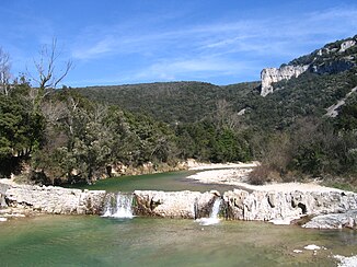
Lower reaches of the Ibie |
||
| Data | ||
| Water code | FR : V5050540 | |
| location | France , Auvergne-Rhône-Alpes region | |
| River system | Rhône | |
| Drain over | Ardèche → Rhône → Mediterranean | |
| source | on the municipal boundary of Villeneuve-de-Berg and Saint-Jean-le-Centenier 44 ° 34 ′ 2 ″ N , 4 ° 32 ′ 17 ″ E |
|
| Source height | approx. 387 m | |
| muzzle | in the municipality of Vallon-Pont-d'Arc in the Ardèche Coordinates: 44 ° 23 '36 " N , 4 ° 23' 59" E, 44 ° 23 '36 " N , 4 ° 23' 59" E |
|
| Mouth height | approx. 78 m | |
| Height difference | approx. 309 m | |
| Bottom slope | approx. 9.4 ‰ | |
| length | 33 km (see notes) | |
| Left tributaries | Rounel , Gardon | |
The Ibie is a river in France that runs in the Ardèche department in the Auvergne-Rhône-Alpes region . Its source stream Ruisseau de Plauzine rises on the municipal boundary of Villeneuve-de-Berg and Saint-Jean-le-Centenier . The Ibie generally drains in a south-westerly direction and flows into the Ardèche as a left tributary after 33 kilometers in the municipality of Vallon-Pont-d'Arc . Most of the year the Ibie is completely dry, after heavy rainfall it offers interesting white water for canoeists .
Places on the river
Web links
Commons : Ibie - collection of images, videos and audio files
