Imihubel
| Imihubel | ||
|---|---|---|
| height | 981 m above sea level M. | |
| location | Canton of Bern , Switzerland | |
| Dominance | 1.09 km → Bütschelegg | |
| Notch height | 30 m ↓ Uecht observatory | |
| Coordinates | 600351 / 189 243 | |
|
|
||
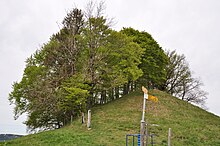
The Imihubel is a hill ( 981 m above sea level ) near Niedermuhlern in the canton of Bern in Switzerland . It is the highest point in the community of Niedermuhlern.
geography
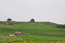
The Imihubel is a little wooded hill in the Schwarzenburgerland . To the northeast it slopes gently towards the Gürbetal . In the south, the short erosion valley Fure and the steep slope of the Rappeflue form its boundary. The area of the Imihubel belongs geologically to the Mediterranean and subalpine molasses in which fossil fossils are found that have been scientifically investigated.
history
Traces of a fortification indicate a settlement.
literature
- Paul Beck, Rolf Friedrich Rutsch: 336 Münsingen, 337 Konolfingen, 338 Gerzensee, 339 Heimberg. Explanations (= Geological Atlas of Switzerland. Explanations . Atlas sheet 21). Kümmerly & Frey AG, 1958, ISSN 1420-2913 ( online [PDF]).
- Rolf Friedrich Rutsch, CW Drooger, HJ Oertli: New Helvetia Faunas from the Molasse between Aare and Emme (Canton of Bern). Foraminifera, Mullusca, Ostracoda . In: Naturforschende Gesellschaft Bern (Hrsg.): Communications from the Naturforschende Gesellschaft in Bern. New episode . tape 16 . Basel 1958, p. 1–36 , doi : 10.5169 / seals-319494 .
Individual evidence
- ^ Rolf Friedrich Rutsch: The type profile of the Helvetia . In: Eclogae Geologicae Helvetiae . tape 51 , no. 1 . Birkhäuser, Basel 1958, p. 107-118 , doi : 10.5169 / seals-162430 .


