
Inclination (magnetism)


The inclination (from the Latin inclinare = (to) to lean, to lean) describes, together with the declination, the direction of the magnetic field lines of the earth's magnetic field in relation to the local coordinate system. It is the angle of inclination to the horizontal, which is given by the local plumb line or by a reference ellipsoid . The sign of the inclination is positive where the ( directed ) field lines are inclined downwards, currently in the north, negative inclination is also referred to as "south".
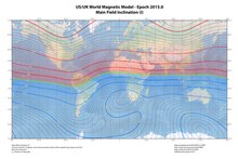
The inclination is close to 0 ° in the vicinity of the equator, in German-speaking countries it is around 62 ° to 70 ° and at the geomagnetic poles exactly ± 90 °. Like the declination, the inclination does not only vary over a large area. In the vicinity of anomalies in particular, there are local deviations from global models of up to more than 50 °, otherwise in the order of magnitude of 2 °, and less over the oceans.
Many migratory birds perceive the direction of the field and also evaluate its inclination component, see magnetic sense .
observation

A magnetic needle shows the inclination when its horizontal axis is oriented transversely to magnetic north. An earth inductor used to be used for more precise measurements . This contained a rotatable coil, which was oriented so that its axis is parallel to the earth's magnetic field, recognizable by the disappearance of the induced alternating voltage . Modern magnetometers measure the vector components of the field with high resolution, including time. Short-term changes are based on currents in the magnetosphere , long- term changes are based on the dynamics of the geodynamos . In the German-speaking area it currently remains almost constant. The greatest change is found in eastern Brazil , at −20 arc minutes per year.
Influence on magnetic compasses
Since only the horizontal component of the magnetic field lines is important for determining the north direction with a magnetic compass and the needle should also remain in a horizontal position to enable a flat design of the compass socket, the inclination must be taken into account when designing such a compass or individually be compensated. If this does not happen or does not happen sufficiently, the compass needle points downwards (in the northern hemisphere) or upwards (in the southern hemisphere). If the incline is too steep, the magnetic needle can no longer rotate freely and jam, which can result in an incorrect display. In the case of spherical compasses , this can lead to a rose lying at an angle in the sphere, but this still shows the correct direction.
To avoid this effect, the two halves of the needle are usually balanced by different weights. Such compasses can only be used in a limited range of inclination. Some manufacturers offer a selection of different doses for their compass models, each designed for a specific inclination zone of the earth. There are up to five such zones.
Another constructive option is the mechanical decoupling of the tiltable magnetic element and the horizontal direction indicator. Compasses with such “global needles” can be used in all inclination zones.
history
The inclination was first observed by Georg Hartmann . In a letter of March 4, 1544 to Duke Albrecht of Prussia, he described not only a declination of about 9 ° East , but also the effect of the inclination:
"To the other | I also find that on the magnet | that he does not turn away from midnight and | lean against the entrance | mod. 9. more or less | how I reported food | but he also breeds under himself "
The first inclination busole was constructed by Robert Norman around 1580 .
Johan Carl Wilcke published the first global inclination map in Stockholm in 1768.
Web links
- Information about the earth's magnetic field (English)
- NOAA - National Geophysical Data Center (USA) Current inclination map of the earth's magnetic field
- Helmholtz Center Potsdam - German Research Center for Geosciences GFZ Calculation of the data for the earth's magnetic field for locations in Germany
Remarks
- ↑ “Midnight” = north, “Ascent” = east.
Individual evidence
- ↑ a b c NOAA: Maps of Magnetic Elements from the WMM 2010 , accessed on February 18, 2014
- ^ RT Merrill, MW McElhinny: The Earth's Magnetic Field - Its History, Origin and Planetary Perspective. Academic Press Inc., London 1983, ISBN 0-12-491240-0 , p. 16 ( Google Books )
- ^ JH Nelson, L. Hurwitz, DG Knapp: Magnetism of the Earth. US Department of Commerce - Coast and Geodetic Survey, Publication 40-1, United States Government Printing Office, Washington 1962, p. 5 ( PDF 7.1 MB )
- ^ Bobby Schenk: Yacht navigation . 9th edition. Delius Klasing Verlag, Bielefeld 2006, ISBN 978-3-7688-1818-6 , p. 68 . ; Pictures online
- ^ RB Langley: Getting Your Bearings - The Magnetic Compass and GPS. GPS World, September 2003, pp. 70–80 ( online )
- ↑ The compensation zones . Retrieved January 6, 2019.
- ^ Franz Maria Feldhaus: Hartmann, Georg . In: Allgemeine Deutsche Biographie (ADB). Volume 50, Duncker & Humblot, Leipzig 1905, p. 27 f.
- ^ RT Merrill, MW McElhinny: The Earth's Magnetic Field - Its History, Origin and Planetary Perspective. Academic Press Inc., London 1983, ISBN 0-12-491240-0 , p. 7 ( Google Books )