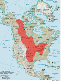
Interior plains
The Interior Plains are a large physiogeographical region of the primary continent Laurentia in present-day North America . They formed when cratons collided 1.8 to 1.9 million years ago in the Trans-Hudson orogeny during the Paleoproterozoic . Thereby forming metamorphic and igneous rocks on the ground. Except for the Black Hills in South Dakota , the area is relatively flat. This region used to be covered by the Western Interior Seaway , in which sediments from the Rocky Mountains settled for millions of years. They were pressed into sedimentary rock by the overlying layers. Some of these formed into coral reefs that shaped the seabed in the Paleozoic .
geology
The Interior Plains have eight different provinces as a large physiographic region :
- Central Lowland
- Great Plains
- Interior low plateaus
- Mackenzie Delta
- Manitoba Lowlands
- Northern Boreal Plains
- Prairie Grasslands
- Southern Boreal Plains & Plateaus
Paleo, Meso and Cenozoic
The region remained untouched by orogeny in the Paleo and Mesozoic Era. Except in the Jurassic when the Sundance Sea existed and in the Cretaceous when the Western Interior Seaway existed, the region was above sea level .
In the Cenozoic , sediments from the erosion of the Rocky Mountains and the Appalachian Mountains , the Ouachita Mountains and the Ozark Plateau were deposited . That is why the area is relatively flat.
