Isla (Deveron)
|
Isla Uisge Ìle |
||
| Data | ||
| location | Moray , Aberdeenshire , Scotland | |
| River system | Deveron | |
| Drain over | Deveron → Moray Firth | |
| source | on the slopes of Carran Hill 57 ° 30 ′ 12 ″ N , 3 ° 4 ′ 15 ″ W |
|
| muzzle | at Rothiemay in the Deveron coordinates: 57 ° 30 ′ 56 " N , 2 ° 46 ′ 42" W 57 ° 30 ′ 56 " N , 2 ° 46 ′ 42" W
|
|
| length | 29 km | |
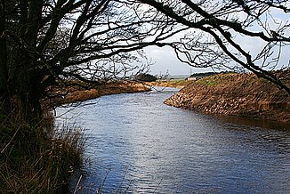
The Isla ( Scottish Gaelic Uisge Ìle ) is a river in Scotland . It is created by the confluence of several source streams in the sparsely populated highlands of Moray on the slopes of Carran Hill . The first three kilometers of the river's course follow a southerly direction before it flows into the Strathisla valley named after it , which the Isla follows in a northeasterly direction.
After around 15 km, the Isla reaches the town of Keith, the only significant settlement on its course. He separates the historic Keith from the planned settlement of Fife-Keith , which was created in the 1810s. Two major highways cross it there: the A95 and the A96 . Beyond Keith, the Isla turns east and finally south-east. From there it marks the border between Moray and Aberdeenshire , or the historic counties of Banffshire and Aberdeenshire, to its confluence with the Deveron, west of Rothiemay . With a length of 29 km, the Isla covers an altitude difference of around 300 m. Although it takes in numerous streams on its course, it does not have any noteworthy tributaries.
Web links
Individual evidence
- ↑ a b c Isla, River. In: David Munro, Bruce Gittings: Scotland. An Encyclopedia of Places & Landscapes. Collins et al., Glasgow 2006, ISBN 0-00-472466-6 .
- ↑ a b Isla. In: Francis H. Groome: Ordnance Gazetteer of Scotland: A Survey of Scottish Topography, Statistical, Biographical and Historical. Volume 4: (Har - Lib). Thomas C. Jack, Grange Publishing Works, Edinburgh et al. 1885, p. 326 .
