Itapissuma
| Itapissuma | |
|---|---|
|
Coordinates: 7 ° 47 ′ S , 34 ° 54 ′ W
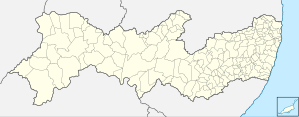
Itapissuma on the map of Pernambuco
|
|
| Basic data | |
| Country | Brazil |
| Federal District |
|
| City foundation | 1982 |
| Residents | 23,769 (IBGE / 2010) |
| City insignia | |
| Detailed data | |
| surface | 74.235 km² |
| Population density | 320.19 inhabitants / km 2 |
| height | 7 m |
| City Presidency | José Bezerra Tenório Filho |
Itapissuma , officially Município de Itapissuma , is a city in the state of Pernambuco , Brazil . Itapissuma belongs to the greater Recife area with 13 other cities . The city has a total area of 74.25 square kilometers and had an estimated population of 26,651 in 2019. The city has the lowest child mortality rate in the agglomeration and has the second highest GDP per capita after Ipojuca .
geography
- State - Pernambuco
- Region - RMR
- Borders - Goiana ( N ), Igarassu ( S and W ), and Itamaraca ( O )
- Area - 74.25 km²
- Climate - Tropical warm and humid
- Average annual temperature - 25.3 ° C
- Main roads - BR-101 and PE-035
Web links
- IBGE : Cidades @ Pernambuco: Itapissuma. Retrieved August 28, 2019 (Brazilian Portuguese).
Commons : Itapissuma - collection of images, videos and audio files


