
Jägersbleeker pond
| Jägersbleeker pond | |||||
|---|---|---|---|---|---|
 |
|||||
|
|||||
|
|||||
| Coordinates | 51 ° 47 '50 " N , 10 ° 23' 11" E | ||||
| Data on the structure | |||||
| Lock type: | dam | ||||
| Construction time: | around 1670 | ||||
| Height above valley floor: | 13.65 m | ||||
| Height of the structure crown: | 587.62 | ||||
| Crown length: | 221.5 m | ||||
| Crown width: | 4.5 m | ||||
| Base width: | 48 m | ||||
| Operator: | Harz waterworks | ||||
| Data on the reservoir | |||||
| Altitude (at congestion destination ) | 586.09 m | ||||
| Total storage space : | 380 000 m³ | ||||
| Catchment area | 0.88 km² | ||||

The Jägersbleeker pond in the Harz is a reservoir near Clausthal-Zellerfeld in the Goslar district in Lower Saxony . It is one of the Upper Harz ponds that were created for Montanz purposes.
description
The reservoir is located in the Upper Harz in the Harz Nature Park . It is located around 3.5 km east-southeast of the Clausthal district . Its water surface is 586.5 m above sea level. NHN , it has a storage volume of 380,000 m³ and its dam is 13.65 m high. The Fortuner pond extends slightly below the Jägersbleeker pond .
The history of the Jägersbleeker pond can be traced back to around 1670.
Near the southeast end of the dam is the August Weppner Hütte , named after the forestry officer August Weppner , a refuge for hikers, in which the stamping point No. 127, Weppner Hütte, Jägersbleeker Teich , the Harzer hiking pin is housed.
Picture gallery
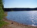
At the pond, June 2008

Pond dam with overflow, May 2012

Widerwaage, May 2012


See also
Web links
Individual evidence
- ↑ Map services of the Federal Agency for Nature Conservation ( information )
- ↑ Harzer Wanderadel: stamp point 127 / Weppner Hütte, Jägersbleeker Teich , on harzer-wandernadel.de