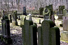
Jewish cemetery (Dransfeld)
The Dransfeld Jewish Cemetery is a Jewish cemetery in Dransfeld ( Göttingen district , Lower Saxony ). It is a protected cultural monument .
description
In the 2,566 m² cemetery on the north-east slope ( Am Hohen Hagen ) of the 422 meter high Dransberg there are 131 tombstones of Jewish deceased from Dransfeld and the surrounding area from the period 1853 to 1937. The cemetery has been owned by the State Association of Jewish Communities since 1960 Lower Saxony . The city and private individuals take care of the maintenance of the cemetery.
history
Before 1853 the Jewish community of Dransfeld had leased the cemetery grounds on the Dransberg from the city of Dransfeld, then it became their property. A total of 791 deceased were buried in the cemetery. The combination of lying and standing gravestones is characteristic. The reclining ones wear only Hebrew characters in accordance with old Jewish tradition. The standing ones are labeled in both Hebrew and German and are of more recent date. Their standing is a symbol of increasing adaptation to the customs of the Christian majority population.
In 1924, 1931, 1983, 1986 and 2009 the cemetery was desecrated.
literature
- Gisela Schucht: Dransfeld. In: Herbert Obenaus (Ed. In collaboration with David Bankier and Daniel Fraenkel): Historical manual of the Jewish communities in Lower Saxony and Bremen . , Volume 1 and 2 (1668 pp.), Göttingen 2005, ISBN 3-89244-753-5 , pp. 488-496
Web links
- Dransfeld. In: Overview of all projects for the documentation of Jewish grave inscriptions in the area of the Federal Republic of Germany ; here: Lower Saxony
- On the history of the Jewish community in Dransfeld
- Historical buildings (city of Dransfeld): Former Synagogue and Jewish cemetery
- Traces of Jewish life in Dransfeld in the Göttinger Tageblatt from July 25, 2014
- Photo gallery: Jewish cemetery near Dransfeld / March 2010 - Photos by P.Ernst
- Anti-Semitism + swastika. Destruction of gravestones in the Jewish cemetery in Dransfeld - June 1, 2009
Individual evidence
Coordinates: 51 ° 29 ′ 42.7 " N , 9 ° 44 ′ 58.2" E


