Whine hedge
| Whine hedge | |||
|---|---|---|---|
|
Jammerhecke, from Brombach |
|||
| Compass direction | west | east | |
| Pass height | 463 m above sea level NN | ||
| state | Hesse | ||
| Valley locations | Schmitten | Neu-Anspach | |
| expansion | District road K 723 | ||
| Mountains | Taunus | ||
| Map (Hessen) | |||
|
|
|||
| Coordinates | 50 ° 17 '43 " N , 8 ° 28' 42" E | ||
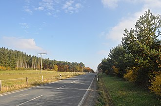
A small pass in the Taunus between the Schmitten districts of Brombach and Hunoldstal and the Neu-Anspach district of Rod am Berg is called Jammerhecke . The pass height is 463 m above sea level. NN . The parking lot at the top of the pass is the starting point for several hiking trails. Shortly before the pass, the district road K 743 meets the district road K 723. The border between Schmitten and Neu-Anspach leads over the Jammerhecke. The neighboring mountain in the south is the Conradsberg (500 meters).
Origin of name
The name Jammerhecke can be traced back to a local legend : in the winter of 1709, supposedly one of the coldest of the 18th century, schoolchildren from Dorfweil, Brombach and Hunoldstal were on their way home from school in Rod am Berg. They were surprised by a snow storm and lost their way. They took shelter under a hedge and froze to death. The parents went on a search and found the children's bodies in the spring. Since the place was associated with suffering and misery, the population called this place Jammerhecke.
literature
- Klaus Wagner: Geliebtes Usinger Land , Walkmühlenverlag, ISBN 3-923658-01-X , published 1982, p. 197/198.
- Helmut Bode: The Jammerhecke between Brombach and Rod am Berg ; in: Ingrid Berg (Ed.): Heimat Hochtaunus , 1988, ISBN 3-7829-0375-7 , pp. 581-582.


