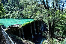
Jenolan River
| Jenolan River | ||
|
Jenolan River with Jenolan Caves Road in the background |
||
| Data | ||
| location | New South Wales , Australia | |
| River system | Hawkesbury River | |
| Drain over | Coxs River → Warragamba River → Nepean River → Hawkesbury River → Tasman Sea | |
| source | Black Mount in the Great Dividing Range 33 ° 45 ′ 6 ″ S , 149 ° 59 ′ 43 ″ E |
|
| Source height | 1190 m | |
| muzzle |
Coxs River in northern Kanangra Boyd National Park Coordinates: 33 ° 47 ′ 54 " S , 150 ° 10 ′ 30" E 33 ° 47 ′ 54 " S , 150 ° 10 ′ 30" E |
|
| Mouth height | 220 m | |
| Height difference | 970 m | |
| Bottom slope | 32 ‰ | |
| length | 30.2 km | |
| Right tributaries | Mumbedah River | |
| Small towns | Jenolan Caves | |
The Jenolan River is a river in the east of the Australian state of New South Wales .
course
It rises northwest of Jenolan Caves , below the ridge of the Great Dividing Range . The river first flows southeast to Jenolan Caves and then turns its course to the east. Below the Krungle Bungle Range it takes up the Mumbedah River , turns to the northeast and flows a little later into the Coxs River .
With the exception of the small town of Jenolan Caves, where a road also crosses the river, it runs through unpopulated area, largely in Kanangra Boyd National Park . Since the Jenolan Caves were electrically lit from 1887, the river was used to generate energy. For this purpose, a weir was built a little below the caves.

