Chigua Jiao
| Chigua Jiao | ||
|---|---|---|
| top left: Guihan Jiao; middle bottom: Chigua Jiao | ||
| Waters | Pacific Ocean | |
| Archipelago | Spratly Islands | |
| Geographical location | 9 ° 43 '9 " N , 114 ° 16' 57" E | |
|
|
||
| length | 460 m | |
| width | 300 m | |
| surface | 11 ha | |
| Highest elevation | 1 m | |
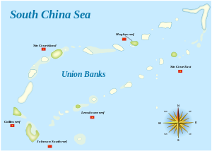
| Johnson South Reef in the southwest of Union Banks Atoll | ||
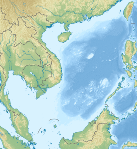
Chigua Jiao ( Chinese 赤 瓜 礁 , Pinyin Chìguā Jiāo or Johnson South Reef ; Vietnamese : Đá Gạc Ma ) is a coral reef in the southwest of the Union Banks atoll (Jiuzhang Qunjiao, Chinese 九章 群 礁 ) of the Nansha Islands in the South China Sea , that is controlled by the People's Republic of China . Chigua Jiao is administered by the People's Republic of China as part of the city of Sansha in its Hainan Province , and the Philippines , Brunei , Vietnam and the Republic of China are claiming the island as part of the territorial conflicts in the South China Sea .
In 1988 there was a bloody battle with the Vietnamese Navy in the waters of Chigua Jiao , in which 64 Vietnamese marines were killed. The reef has been protected by an artificial dam since 1990. It is completely flooded at spring tide , at normal tide numerous rock peaks protrude clearly from the water. Quayside facilities and other fortifications as well as a permanently manned base of the Chinese Navy have now been built on these rocks and in May 2014 a land area of around 11 hectares was raised . This has been partially planted with coconut palms and Chinese hemp palms . At one point of the reef formation ( 9 ° 43 ′ N , 114 ° 17 ′ E ) a lighthouse was built.
In March 2011, China Mobile connected Chigua Jiao and the surrounding sea area to the Chinese cell phone network.
See also
Individual evidence
- ↑ Jojo Malig: Chinese fleet eyes bumper harvest . In: ABS CBN News , July 17, 2012. Retrieved October 29, 2013.


