
Yossypivka (Radechiv)
| Yossypivka | |||
| Йосипівка | |||

|
|
||
| Basic data | |||
|---|---|---|---|
| Oblast : | Lviv Oblast | ||
| Rajon : | Radechiv Raion | ||
| Height : | no information | ||
| Area : | 0.514 km² | ||
| Residents : | 242 (2001) | ||
| Population density : | 471 inhabitants per km² | ||
| Postcodes : | 80203 | ||
| Area code : | +380 3255 | ||
| Geographic location : | 50 ° 18 ' N , 24 ° 36' E | ||
| KOATUU : | 4623984502 | ||
| Administrative structure : | 1 village | ||
| Statistical information | |||
|
|||


Jossypiwka ( Ukrainian Йосипівка ; Russian Йосиповка Jossipowka , Polish Józefów ) is a village in the western Ukrainian Lviv Oblast with about 240 inhabitants.
The village belongs with the village of Polowe ( Полове ) to the district council of Polowe.
history
The village was founded in 1783 in the course of the Josephine colonization on the grounds of the Radychiw chamber property and was named after HR (Count) Józef Mier. German colonists were settled there.
Shortly after the establishment, a Helvetic parish was founded by virtue of the tolerance patent , which belonged to the Evangelical Superintendentur HB Galicia and comprised other German colonies Hanunin , Romanówka, Sabinówka , Zboiska and Antonin, as well as mostly Ruthenian Stanin , Suszno , Zabawa , Wulka, Chołojów , Busk and Różanka . There were some subsidiary communities, including in Mierów , Heinrichsdorf, Sobolówka, Karolówka and Sapieżanka . In 1846 the Protestant brick prayer house was built. In 1875 there were 335 Protestants in Jozefów and one Protestant school with 4 classes.
In 1900 the Józefów community had 52 houses with 315 inhabitants, 270 German-speaking, 38 Polish-speaking, 6 Ruthenian-speaking, 27 Roman Catholic, 7 Greek Catholic, 281 of other faiths.
After the end of the First World War in 1918 and the collapse of the Austro-Hungarian monarchy, Józefów became part of Poland.
In 1921 the Józefów community had 47 houses with 281 inhabitants, of which 288 were Germans, 51 Poles, 2 Ruthenians, 8 Jews (nationality), 255 Protestant, 21 Roman Catholic, 2 Greek Catholic, 3 Jews (religion).
During the Second World War it belonged first to the Soviet Union and from 1941 to the General Government, from 1945 back to the Soviet Union, now part of the Ukraine .
Attractions
- Former Protestant church (built in 1848)
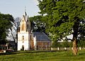
Former Protestant church

Web links
- Józefów, Białokiernica (po rusku Josyfiw) . In: Filip Sulimierski, Władysław Walewski (eds.): Słownik geograficzny Królestwa Polskiego i innych krajów słowiańskich . tape 3 : Haag – Kępy . Sulimierskiego and Walewskiego, Warsaw 1882, p. 612 (Polish, edu.pl ).
- Impressions from Josefów (Yosyvibka), Ukraine (PDF; 303 kB). Aid Committee of the Galiziendeutschen eV Publication from 06/01/2012. Retrieved December 13, 2016.
Individual evidence
- ↑ Henryk Lepucki: Działalność kolonizacyjna Marii Teresy i Józefa II w Galicji 1772-1790: z 9 tablicami i MAPA . Kasa im. J. Mianowskiego, Lwów 1938, p. 163-165 (Polish, online ).
- ↑ Schematism of the Evangelical Church in Augsb. and Helvet. Confession in the kingdoms and countries represented in the Austrian Imperial Council . Vienna 1875, p. 211-213 ( online ).
- ↑ Ludwig Patryn (Ed.): Community encyclopedia of the kingdoms and countries represented in the Reichsrat, edited on the basis of the results of the census of December 31, 1900, XII. Galicia . Vienna 1907.
- ↑ Główny Urząd Statystyczny: Skorowidz miejscowości Rzeczypospolitej Polskiej. Województwo tarnopolskie . Warszawa 1928 (Polish, online [PDF]).