
King Oskar Land

König-Oskar-Land is a phantom island in the Arctic Ocean , which was suspected to be northwest of Rudolf Island in the Franz Joseph Land archipelago .
During the Austro-Hungarian North Pole expedition , the most important result of which was the discovery of Franz Joseph Land, Julius Payer made his third sleigh trip to Cape Fligely in the north of Rudolf Island in 1874 . Here he meant to see a land mass in the northwest, 60 to 70 miles away, which he named after King Oskar II of Sweden and Norway. Land that he saw in the north was called Payer Petermann Land .
Fridtjof Nansen first had doubts about the existence of König-Oskar-Land when he left the ship on his expedition with the Fram and crossed Franz-Josef-Land with his companion Hjalmar Johansen :
“That King Oskar Land cannot be of great extent seems to me to be clear from the fact that the wind, as we have seen in the course of winter or spring, carried the ice unhindered away from the land, so that hardly any to the north or north-west larger, coherent land mass that it would have been able to hold back. "
King Oskar Land was still shown on Nansen's own map, however, as was Frederick Jackson's preliminary map sketch from 1897. On Jackson's map from 1898 there was no longer King Oskar Land (instead two new phantom islands, Harmsworth Island and Albert- Edward Island , north of Prince Georg Land ). In his book A thousand days in the Arctic , he expressed his doubts: "I doubt that King Oskar Land even exists, and if it does, it can only be small."
In 1900 Luigi Amadeo of Savoy attempted to reach the North Pole via Franz-Joseph-Land . To do this, he wanted to travel as far north as possible with his ship Stella Polare , to Rudolf Island or, preferably, to Petermann Land or König Oskar Land. But he could find no trace of the hypothetical islands.
The final proof that Petermann and König-Oskar Land do not exist was provided by Georgi Brusilov's Russian expedition from 1912 to 1914 . His schooner St. Anna, frozen in the ice, drifted right through the assumed position of Petermann-Land without any land being seen in any direction. A group of sailors led by Valerian Albanov tried to use Nansen's map to go south via King Oskar Land, but found only sea ice. Obviously Payer was wrong.

Nansen's map from 1896
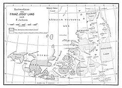
Jackson's preliminary map from 1897

Jackson's map from 1898


Individual evidence
- ↑ Julius Payer: The Austro-Hungarian North Pole Expedition in the years 1872–1874, together with a sketch of the second German North Pole expedition 1869–1870 and the polar expedition of 1871 . Alfred Hölder, Vienna 1876, p. 338; Text archive - Internet Archive .
- ↑ Julius Payer: The Austro-Hungarian North Pole Expedition in the years 1872–1874, together with a sketch of the second German North Pole expedition 1869–1870 and the polar expedition of 1871 . Alfred Hölder, Vienna 1876, p. 334, Textarchiv - Internet Archive .
- ↑ Fridtjof Nansen: In night and ice . Second volume. Brockhaus, Leipzig 1897, p. 351, Textarchiv - Internet Archive .
- ^ Moritz Lindeman : Franz-Joseph-Land. Controversy and New Discoveries . In: Globus . Volume 71, 1897, pp. 44-48, p. 46 .
- ↑ “ I doubt if King Oscar Land exists at all, or, any way, it can only be of small extent. Frederick G. Jackson: A thousand days in the Arctic . Harper, New York / London 1899, p. 222, Textarchiv - Internet Archive .
- ↑ Ludwig Amadeus of Savoy: The Stella Polare in the Arctic Ocean . Brockhaus, Leipzig 1903, p. 69, Textarchiv - Internet Archive
- ↑ Ludwig Amadeus of Savoy: The Stella Polare in the Arctic Ocean . Brockhaus, Leipzig 1903, p. 72, Textarchiv - Internet Archive
- ^ William James Mills: Exploring Polar Frontiers - A Historical Encyclopedia . tape 1 . ABC-CLIO, 2003, ISBN 1-57607-422-6 , pp. 108 (English, limited preview in Google Book search).
Coordinates: 82 ° N , 52 ° E