K2 (Ötztal Alps)
| K2 | ||
|---|---|---|
|
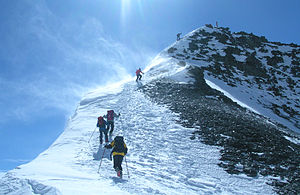
K2 from the east |
||
| height | 3253 m above sea level A. | |
| location | Tyrol , Austria | |
| Mountains | Ötztal Alps | |
| Dominance | 0.13 km → Rostizkogel | |
| Notch height | 43 m ↓ Scharte to Rostizkogel | |
| Coordinates | 46 ° 57 '56 " N , 10 ° 47' 39" E | |
|
|
||
| Normal way | from the Rifflsee | |
|
The summit structure of the K2 |
||
The K2 is a three-thousand-meter peak in the Ötztal Alps . It is located in the rear of the Pitztal , belongs to the Kaunergrat and is mostly climbed from the Rifflsee over the Mittlere Lochferner. Since the Pitztaler K2 is a subordinate summit and significantly smaller than its immediate northern neighbor, the Rostizkogel ( 3394 m ) and its southern neighbor, the Löcherkogel ( 3324 m ), it is usually not entered on maps with its name, but only as a survey point. However, the K2 is a very worthwhile destination among ski tourers and is very popular on fair-weather weekends in late winter.
The name of the mountain, which has only recently become naturalized and, for example, is not mentioned in earlier editions of the "Ötztal Alps" guide, comes from the external similarity to the second highest mountain in the world, the K2 in the Karakoram .
Routes
At the Rifflsee follow the path into the Riffltal. Cross the stream directly below the first step (plank). Through an incision further up to the right on the back pulling up to the NW. Up on the steep but easy and broad ridge. When you reach the gravel plain at the 'Schneidigen Wändle' head west and climb over a steep moraine slope. Follow the creek to the glacier tongue of the middle Lochferner and up this on the right. At the stone men on the right because of the longitudinal gaps. Continue over the ice to the uppermost glacier bay and onto the left bank of the glacier (beware of the crevice). Over the steep but gentle mountain flank up to the summit with the summit cross.
Impressions
cards
- Alpine Club Card 30/6 "Ötztal Alps, Wildspitze" (1: 25000)
- Kompass hiking map 42 "Inneres Ötztal" (1: 25000)


