
Löcherkogel
| Löcherkogel | ||
|---|---|---|
 Löcherkogel from the east |
||
| height | 3324 m above sea level A. | |
| location | Tyrol , Austria | |
| Mountains | Kaunergrat , Ötztal Alps | |
| Dominance | 1 km → Rostizkogel | |
| Notch height | 241 m ↓ Rostizjoch | |
| Coordinates | 46 ° 57 '33 " N , 10 ° 47' 28" E | |
|
||
| rock | Veteran | |
| First ascent | September 25, 1900 by A. Hintner, F. Hörtnagl, J. Pircher, A. Posselt | |

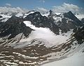
The Löcherkogel is 3324 m above sea level. A. high mountain of the rear Kaunergrat , a mountain range of the Ötztal Alps . Together with the Wurmtaler Kopf , Hapmesköpf and Grubenkarspitze, it borders the large glacier kar of the Rifflferner , on the northern side of which it lies. It has a distinctive, steep, dome-like summit structure with three pronounced ridges to the north, south-east and south-west.
It is connected to K2 and the Rostizkogel, which only slightly towers above it, via the north ridge . The glaciers in the high region are named after the Löcherkogel. The southern Lochferner lies directly to the north of its SE ridge, while the middle and northern Lochferner lie at the Rostizkogel. Due to its height and its location, the Löcherkogel is an excellent vantage point.
Routes
Several routes lead to the top of the mountain. The most important are:
- From the north: From the Pitztal or Kaunertal to the Rostizjoch. Over the north ridge moderately difficult to the summit (II)
- From the south: From the Rifflsee on the Offenbacher Höhenweg into the Rifflkar and onto the moraine slopes far behind. When the glacier stream branches off to the right of the path ("Die Loch") and along the glacier streams and rock terraces in an arc to the north into the northern basin of the Rifflferner. Over the Ferner to the steep, rocky southern flank of the mountain. Now over steep rock and rubble to the summit structure of the Löcherkogel, which you climb from the east over the southeast ridge.
- From the southeast (almost ice-free path): As with the route above to the edge of the Rifflferner. Now directly north over the remains of glacier and firn to the southeast flank of the Löcherkogel. Over the steep rock face (partly brittle, partly grippy rock) up to the ridge. Via the mostly easy southeast ridge with a few bypasses on the south side to the steeply towering summit structure and in grippy rock to the summit with Steinmann .

Löcherkogel from the southeast

The summit structure of the Löcherkogel from the southeast
View of the rear Kaunergrat from the summit


literature
- Walter Klier : Alpine Club Guide Ötztal Alps . Bergverlag Rudolf Rother , Munich 2006, ISBN 3-7633-1123-8 .
- Ludwig Obersteiner: Guide through the Ötztal Alps . Reichenstein-Verlag, Vienna 1925.