Kalambo (district)
Kalambo District
|
|||
|---|---|---|---|
| Basic data | |||
| Country | Tanzania | ||
| region | Rukwa | ||
| surface | 4715 km² | ||
| Residents | 207,700 (2012) | ||
| density | 44 inhabitants per km² | ||
| ISO 3166-2 | TZ-20 | ||
Coordinates: 8 ° 32 ′ S , 31 ° 18 ′ E
Kalambo is the southernmost of the three districts of the Rukwa region in Tanzania with the administrative center in Matai . The district borders in the north on the district Nkasi , in the northeast on the district Sumbawanga , in the east on the region Mbeya and in the south and west on Zambia , whereby the border runs through Lake Tanganyika in the west .
geography
The district has a size of 4715 square kilometers and 207,700 inhabitants (as of 2012). It lies in the western part of the East African rift at an altitude of 750 to 1200 meters above sea level. The country consists of the coastal strip on Lake Tanganyika and the Ufipa Plateau. This is characterized by Miombo forests and open grasslands. In the south, the highest peaks rise to 2220 meters. The largest river is the Kalambo , which also forms the border with Zambia and flows into Lake Tanganyika. The climate is warm and temperate, Cwb according to the effective climate classification . The precipitation of about 1000 millimeters per year falls mostly in the rainy season from November to April, especially the months June to September are very dry. The average annual temperature is 19.4 degrees Celsius, with the coolest months in June and July and the warmest in October.
history
The name of the district comes from the Kalambo River. The district was split off from Sumbawanga district in 2012.
Administrative division
The district consists of a council, the five divisions Matai, Kasanga, Mwimbi, Nkoswe and Mwazye as well as 17 parishes (wards):
- Kasanga
- Mkowe
- Msanzi
- Matai
- Sopa
- Mwazye
- Katazi
- Mwimbi
- Mambwekenya
- Mwembenkoswe
- Legeza Mwendo
- Ulumi
- Mnamba
- Katete
- Kisumba
- Mkali
- Kilesha
population
Most of the population belongs to the Bantu- speaking Fipa ethnic group . The population fell from 212,078 in 2002 to 207,700 in 2012. Half of those over five spoke Swahili, seven percent spoke Swahili and English. Over forty percent were illiterate (as of 2012).
Facilities and services
- Education: Around 60,000 students attended 98 elementary schools. 5050 young people were taught in 19 secondary schools, fifteen of these schools were state-run and four were private (as of 2019).
- Health: Four health centers and 61 pharmacies were available for the medical care of the population. The most common diseases were malaria , HIV , high blood pressure, diabetes , tuberculosis and pneumonia. The AIDS cases decreased from 2.4 percent in 2015 to 1.6 percent in 2016.
Economy and Infrastructure
|
 |
Nature reserves, sights
- Lake Tanganyika: In the west, Kalambo has a share of the second largest lake in Africa. It is 660 kilometers long and at 1,436 meters it is also the second deepest lake on earth.
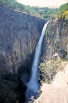
- Kalambo Falls : This 221 meter high waterfall on the border with Zambia is the second highest waterfall in Africa and one of the highest waterfalls on earth.
Web links
Individual evidence
- ^ A b Tanzania Regional Profiles, 15 Rukwa Regional Profiles. (PDF) The United Republic of Tanzania, 2016, p. 15 , accessed on March 13, 2020 .
- ↑ Historia | Kalambo District Council. Retrieved March 13, 2020 .
- ↑ a b Kalambo District | Rukwa region. Retrieved March 13, 2020 .
- ↑ Maps for thr World, Map 500k - xc36-1. Russian Army Maps, accessed March 13, 2020 (Russian).
- ^ Kalambo River. Retrieved March 13, 2020 (de-US).
- ^ Matai climate: Average Temperature, weather by month, Matai water temperature - Climate-Data.org. Retrieved March 13, 2020 .
- ↑ Strategic Plan 2016 / 2017–2020 / 2021. (PDF) p. 1 , accessed on March 13, 2020 .
- ↑ 2012 Population and Housing Census. (PDF) National Bureau of Statistics and Ministry of Finance, March 2013, p. 141 , accessed on March 13, 2020 .
- ↑ Fipa | people. Encyclopaedia Britannica, accessed March 13, 2020 .
- ↑ Tanzania Regional Profiles, 15 Rukwa Regional Profiles. (PDF) The United Republic of Tanzania, 2016, p. 71 , accessed on March 13, 2020 .
- ↑ a b Takwimu (Statistics). Retrieved March 13, 2020 .
- ↑ Strategic Plan 2016 / 2017–2020 / 2021. (PDF) p. 2 , accessed on March 13, 2020 .
- ↑ Kilimo (agriculture). Retrieved March 13, 2020 .
- ↑ Tanzania Regional Profiles, 15 Rukwa Regional Profiles. (PDF) The United Republic of Tanzania, 2016, pp. 123, 125, 128 , accessed on March 13, 2020 .
- ↑ Uvuvi (fishing). Retrieved March 13, 2020 (Swahili).
- ↑ Kinyage, JPH and Lamtane, HA: Diversity and Abundance of Ornamental Cichlids at Katonga in Lake Tanganyika. In: Tanzania Journal of Agricultural Sciences. Sokoine University of Agriculture, Morogoro, 2018, accessed March 13, 2020 .
- ^ Tanzania Trunk Road Network. Retrieved March 13, 2020 .
- ↑ Lake Tanganyika | lake, Africa. Encyclopaedia Britannica, accessed March 13, 2020 .
- ↑ Kalambo Falls - Zambia Tourism. Retrieved March 13, 2020 .


