
Kalaw
| ကလောမြို့ Kalaw |
|||
|---|---|---|---|
|
|||
| Coordinates | 20 ° 38 ′ N , 96 ° 34 ′ E | ||
| Basic data | |||
| Country | Myanmar | ||
|
State |
Shan state | ||
| ISO 3166-2 | MM-17 | ||
| height | 1300 m | ||
| Residents | 57,797 (2014) | ||
 Kalaw, streetscape
|
|||

Kalaw (officially: ကလောမြို့) is a place on the western edge of the Shan Mountains in Myanmar with about 58,000 inhabitants (as of 2014) and is located at an altitude of about 1320 m . It lies roughly halfway between the larger cities of Thazi and Taunggyi and is considered to be the entry point into southern Shan State .
geography
The place is on the Shan Plateau in eastern Myanmar on the southeastern edge of the Shan State. During the British colonial era, the place was popular as a climatic health resort ("Hill Staion") among soldiers and their families due to the pleasant, cool climate.
population
The place is surrounded by several Shan hill tribe villages. The population of Kalaw consists for the most part of Shan , in addition there are descendants of Nepalese Gurkhas and Indian Hindus and Muslims , who came into the country in the colonial times from the English for railway and road construction as well as with the British military.
Sightseeing and tourism
There are several pagodas in the village , the Shwe Oo Min cave with 700 Buddha figures, churches and a mosque . There are four temples in Kalaw: the Aung-Cha-Tha Temple in the center of the city with a mirror-adorned stupa and four Buddha figures inside, the Dama-Yon-Tha Temple also in the city center, the Hsu-Taung-Pye- Pagoda with several small stupas and the Thane Taung monastery on a hill north of the city. Also in the center of town is Christ-the-King-Church, a brick-built Catholic church with a statue of Christ from Italy.
One of the city's most important tourist attractions is the market, which takes place every five days in Kalaw and where the residents of neighboring villages in particular offer their goods. There are numerous hotels and restaurants in the village.
The surrounding villages and the Pindaya caves can be visited as day tours. Today Kalaw is also the starting point for trekking tours to the nearby Inle Lake .
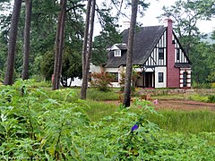
Amara Resort, a former British residence in Kalaw

Aung Cha Tha Temple

Market scene in Kalaw

Hsu Taung Pye Pagoda with several small stupas
.jpg)
.jpg)
.jpg)
.jpg)
traffic

The place is connected to the country's infrastructure both by road and rail. For tourists, express buses are offered from Kalaw to the surrounding villages and especially to Pindaya . The railway line goes to Thazi and Shwenyaung , with the travel time to Thazi taking about four to five hours and that to Shwenyaung about three hours. The nearest airport is in Heho east of Kalaw.
supporting documents
- ↑ Kalaw at citypopulation.de (census data according to The 2014 Myanmar Population and Housing Census - The Union Report , May 2015, Myanmar Department of Population).
- ↑ a b c d e f g "Kalaw". In: A. and M. Markand, Martin H. Petrich, Volker Klinkmüller: Myanmar (Burma). Stefan Loose Travel Handbooks, DuMont Reiseverlag, Berlin 2003; Pp. 350-358. ISBN 978-3-89794-261-5 .
- ↑ a b c "Kalaw". In: Tobias Esche: Myanmar. Out and about in the land of the white elephants. Trescher Verlag, Berlin 2014; Pp. 196-198. ISBN 978-3-89794-261-5 .
- ↑ Kalaw - the former British Colonial Town and the Colors of the Shan Hills on myanmarinsider.blogspot.com, December 21, 2014; accessed on November 17, 2019
literature
- "Kalaw". In: Tobias Esche: Myanmar. Out and about in the land of the white elephants. Trescher Verlag, Berlin 2014; Pp. 196-198. ISBN 978-3-89794-261-5 .
- "Kalaw". In: A. and M. Markand, Martin H. Petrich, Volker Klinkmüller: Myanmar (Burma). Stefan Loose Travel Handbooks, DuMont Reiseverlag, Berlin 2003; Pp. 350-358. ISBN 978-3-89794-261-5 .
Web links
- Kalaw - the former British Colonial Town and the Colors of the Shan Hills on myanmarinsider.blogspot.com, December 21, 2014; accessed on November 17, 2019