Kalkofeninsel
| Kalkofeninsel | ||
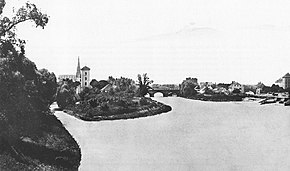
 Kalkofeninsel (left) with Muffatbrunnhaus, photo from 1865 |
||
| Geographical location | ||
|
|
||
| Coordinates | 48 ° 8 '1 " N , 11 ° 35' 23" E | |
| Waters 1 | Little Isar | |
| Waters 2 | Auer Mühlbach | |
| length | 489 m | |
| width | 103 m | |
| surface | 3.3 ha | |
The Kalkofeninsel in Munich is not a real island, but a peninsula between the Kleiner Isar , Auer Mühlbach and the outer Ludwigsbrücke . It is named after a municipal lime kiln that was operated there. The peninsula is 489 meters long in the direction of the river, up to 103 meters wide, and covers an area of 3.3 hectares .
Since the Brunnhaus on the Isarberg (also called Brunnhaus am Gasteig) was one of the oldest of Munich's Brunnhäuser and technically out of date, city planner Franz Karl Muffat proposed the construction of a new Brunnhaus on the Kalkofeninsel in 1833. However, it was only started in 1835 and put into operation in early 1837. After the introduction of the central water supply in 1883, the Muffatbrunnhaus was converted into a power station, which was called the Muffatwerk and was primarily used to supply the new electric tram.
Shortly afterwards, between 1897 and 1901, in a kind of Baroque Art Nouveau style, the Müllersche Volksbad was built directly on Ludwigsbrücke . As with the Muffatwerk, the architect was Carl Hocheder .
With the construction of the hydropower plants on the Werkkanal, the Muffatwerk lost its importance and was shut down in 1973. The huge turbine hall stood empty for many years before it was converted into a concert and event hall with a café between 1990 and 1993. The Ampere club and a beer garden have been added in recent years. The Volksbad, which was restored between 1978 and 1984 and technically complex retrofitted, is still very popular today.
The name Kalkofeninsel is still in use, although the lime kiln was demolished around the middle of the 19th century and replaced by a new one on the neighboring Kalkinsel . The term “ Coal Island” , which can be verified from the middle of the 19th century, never caught on, but repeatedly leads to confusion with the Museum Island , which was also called Coal Island at the end of the 19th century.
literature
- Peter Klimesch: Isar lust. Discoveries in Munich. München-Verlag 2011, ISBN 978-3-937090-47-4 (therein chapter on the Isar islands in Munich.)
- Christine Rädlinger : History of the Munich city streams . Ed .: City Archives Munich . Franz Schiermeier Verlag, Munich 2004, ISBN 978-3-9809147-2-7 .
- Franz Schiermeier: Munich city streams. Travel guide to the lifelines of a city . Franz Schiermeier Verlag, Munich 2010, ISBN 978-3-9813190-9-5 .
- Peter Klimesch: Munich Isar Islands - Past, Present and Future. In: Ralf Sartori (Ed.): Die neue Isar, Volume 4. Munich 2012. ISBN 978-3-86520-447-9 .
Footnotes
- ↑ City map of the statistical-topographical bureau "Surroundings of Munich", 1812.
- ↑ City address book from 1880/81. There it says under the address "island on which" that "the northern part of an eastern part of a peninsula surrounded by the Isar and the Auermühlbach is called" Coal Island "." Also: city maps by Gustav Wenng from 1858/59 and Baedeker 1880.
