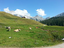
Kallbrunnalm
The Kallbrunnalm ( 1454 m above sea level. A. ), which is below Küh- and high Kranz is, is the largest mountain pasture in the Bavarian-Austrian border area. It covers an area of 254 hectares . The settlement belongs to the cadastral municipality of Oberweißbach in the east of the municipality of Weißbach bei Lofer in the state of Salzburg in Austria .
The Alm is located in an enclave within the Fallck district of the Saalforste . The area belongs to the Kalkhochalpen nature reserve in the Berchtesgaden Alps .
History of the Alm
The Kallbrunnalm is first mentioned in a document in 1386. Since the Alm belonged to the Berchtesgaden Abbey , farmers from Berchtesgaden owned the Almrecht , but transferred part of it to farmers from Pürzlbach and other places in the 18th century . That's why the Alm has now grown to 30 huts. Since the damming and construction of the Dießbach reservoir in 1961, it is connected to a forest road in the valley.
Alpine farming
The Kallbrunnalm lives mostly from tourism today. Nevertheless, the owners of the Alm run a cheese dairy . In addition, the farmers of the Alm have come together to form an agricultural community .
hikes
The Kallbrunnalm is one of the most popular hiking destinations in Weißbach bei Lofer . It can be accessed from the Hirschbichlpass . For this tour, however, surefootedness and hiking experience are required. Another possibility is from the Weißbachtal. Hiking experience is also required here. The Kühkranz and the Hochkranz can be reached from the Kallbrunnalm. Most of the route is a via ferrata and only feasible for mountaineers with years of experience. It is also possible to hike the Dießbachstausee, the Seehornsee and the Seehorn .
Individual evidence
- ↑ "Rother Wanderführer-Berchtesgadener Land" ISBN 978-3-7633-4226-6 by Heinrich Bauregger, p. 100 f.
- ↑ Map of the Saalforste , Bavarian State Forests (PDF)
- ↑ Information on salzburger-saalachtal.com ( Memento from April 28, 2014 in the Internet Archive )
- ↑ Information on the Kallbrunnalm at berchtesgadener-land.com
Web links
- Website of the Kallbrunnalm snack station
- Kallbrunnalm . In: Agricultural and cultural heritage database . Society for Agricultural History
Coordinates: 47 ° 30 ′ 53.2 " N , 12 ° 48 ′ 34.5" E
