
Kaltenstein Path
| Kaltenstein Path | |
|---|---|
 Cold stones |
|
| Data | |
| length | 7.8 km |
| location | Saarlouis district |
| Markers |
 |
| Start / finish point | Sports and leisure center Dillinger 71, 66822 Lebach 49 ° 24 '9.5 " N , 6 ° 53' 23" O |
| Type | Circular hiking trail |
| Height difference | 330 m |
| The highest point | 408 m above sea level NN |
| Lowest point | 221 m above sea level NN |
| Level of difficulty | moderate |
| season | All year round |
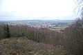
| Viewpoints | Panoramic view over Lebach at the summit of the Hoxberg |
| particularities | Kaltensteine, Hoxberg, historical horse troughs |
The Kaltensteinpfad is a circular hiking trail near Lebach in Saarland . It is one of the so-called dream loops in the route system of the Saar-Hunsrück-Steig and leads over the Hoxberg .
Characteristic
The cold stone path is a predicate trail (dream loop) in the form of a lying eighth, Woods trails through varied, primeval forest (relics of the hurricanes of 1990) are at a historic horse trough and the "cold stones" passed over the summit of Hoxbergs. The steep, long ascent to the Hoxberg makes the 7.8 km long path moderately difficult. The trail was rated with 56 adventure points by the German Hiking Institute.
course
From the parking lot, a path leads directly into the forest past the tennis facility. The water treading facility can be reached via a narrow path that then leads into a forest path. We continue following the signs to the historical boundary stones from 1762. The boundary stones point to the " four rule " of Lebach. Information boards explain the origin and the signs on the boundary stones. The next stop on the way is a historic horse trough that was created in 1940 to feed the horses of the Lebach barracks. The path leads down through the so-called fairytale forest. Display boards show what devastation hurricane Wiebke wreaked havoc in this forest in 1990. The fairy tale forest is the part that has been left to its own devices. The route continues between mosses and ferns to a wet biotope over which a stick dam leads.
The path now climbs steeply for about 1 km to the Hoxberg. Past a tunnel with bats it goes bergarb to the former camp of the Reich Labor Service (RAD) on the outskirts of Zollstock, which has now become a place with a barbecue hut. During the Third Reich , 180 forced laborers who worked on the Siegfried Line were housed here.
From the former RAD warehouse it goes uphill, immediately left over a mossy path to the natural monument " Kaltenstein ". This is an approximately 270 million year old conglomerate rock made of the " Rotliegend ", a solidified mixture of pebbles and sandstone. It is said that Celtic druids sacrificed to their gods here over 2000 years ago.
Shortly behind the stones, the forest opens up to a panoramic view over Lebach. A display board shows the districts up to the Schaumberg . The path continues steeply downhill to the foot of the Hoxberg back to the destination, the parking lot in front of the sports center.
Attractions

Old landmarks

Historical horse drinks

RAD warehouse
Panoramic view of Hoxberg

Cold stones


