Kamenice (Jizera)
|
Kamenice Kamnitz |
||
|
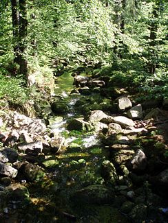
Upper course of the Kamenice |
||
| Data | ||
| location | Liberecký kraj , Czech Republic | |
| River system | Elbe | |
| Drain over | Jizera → Elbe → North Sea | |
| Source height | 1070 m nm | |
| muzzle | At Spálov in the Jizera coordinates: 50 ° 38 ′ 2 ″ N , 15 ° 18 ′ 0 ″ E 50 ° 38 ′ 2 ″ N , 15 ° 18 ′ 0 ″ E
|
|
| length | 36.7 km | |
| Catchment area | 218.6 km² | |
| Left tributaries | Desná | |
| Reservoirs flowed through | Josefův Důl dam | |
The Kamnitz ( Czech Kamenice ) is a right tributary of the Jizera in the Czech Republic .
It rises in several source streams in the Jizera Mountains in Bohemia at the pigeon house (Holubník, 1070 m). The Kamnitz is dammed below the former glassmaker's village Christiansthal (Kristiánov), a district of Friedrichswald ( Bedřichov ), of which only the fox hut ( Liščí bouda ) remained and is used as a glass museum .
The Josefův Důl dam above the village Josefův Důl was built between 1976 and 1982, has a dam height of 43 m and a capacity of 23 million m³ and is the largest in the Jizera Mountains. It is used to supply drinking water and is therefore not approved for recreational purposes.
The Kamnitz flows through the town of Tannwald (Tanvald) on its course to the south , where the Desse (Desná) joins. It flows on through Großhammer (Velký Hamr).
After 36 km it flows into the Jizera at the small village Spalow (Spálov u Semil) near Eisenbrod (Železný Brod) . The Kamnitz is the most water-rich tributary of the Iser.
On July 29, 1897, the Kamnitz caused a heavy flood after 310 mm of precipitation / m² had fallen in the Jizera Mountains on that day. The rupture of the dam on the White Desse on September 18, 1916 also caused damage along the Kamnitz as a result of the tidal wave.

