
Kamiak Butte County Park
|
Kamiak Butte County Park
|
||
 The slopes of Kamiak Butte with wheat fields |
||
| location | Whitman County , Washington , USA | |
| surface | 121 ha | |
| Geographical location | 46 ° 52 ' N , 117 ° 10' W | |
|
||
| Sea level | from 810 m to 1110 m | |
| Setup date | 1965 | |
| administration | Whitman County Parks and Recreation Department | |

The Kamiak Butte County Park is a regional reserve in Whitman County in the State of Washington . It is located between the towns of Palouse and Pullman in east Washington near the Idaho border . The park is named after Chief Kamiakin , a leader of the Yakama tribal group .
Most of the 298 acres (121 ha) park area consists of forestry areas on the northern slopes of Kamiak Butte . The mountain itself forms an "island" made of Precambrian quartzite that rises about 1,000 ft (approx. 300 m) from the surrounding wheat fields. The reddish rocks once formed the basin for a prehistoric lake, and the grains of sand enclosed in them still sparkle in the sunlight. In later geological development, the Kamiak Butte became part of a mountain range that was eventually engulfed by Cenozoic lava flows that buried most of eastern Washington under layers of basalt .
The intensive wheat and lentil cultivation in the region has made the Kamiak Butte an important retreat for indigenous plant and animal species; 170 plant, 130 bird and 30 mammal species can be observed in the park.
The main attraction for most park visitors is the Pine Ridge Trail , a 3.5 mi (5.6 km) circular trail that begins at a parking lot and ascends through evergreen forest to an exposed ridge. The path runs along the ridge and offers views of the surrounding Palouse landscape before descending back into the forest. A short “summit lead” leads to the highest point of the mountain, a rock spur with a height of 3,641 ft (1,110 m). Campsites are open all year round, except in dry periods when there is a risk of fire. Guided tours are offered in the spring and summer months; Other leisure options include an amphitheater, picnic areas, outdoor grills, shelters and a playground; Toilets are available.
Two interconnected transmission facilities for amateur radio are installed near the summit. The transmission frequencies are 146.74 MHz (with a negative offset of 600 kHz on the 2-meter antenna) and 53.75 MHz (with a negative offset of 1.7 MHz and a pilot tone of 100 Hz on the 6-meter antenna) -Antenna). The transmitters are also part of Washington State's Evergreen Intertie, an interconnected system for amateur radio and emergency communications throughout the state.
The Kamiak Butte and the Steptoe Butte form a National Natural Landmark . The Pine Ridge Trail is listed as the National Recreation Trail in the National Trails System .
gallery
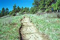
The Pine Ridge Trail on Kamiak Butte
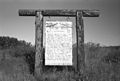
Information board at Kamiak Butte

Picnic area at Kamiak Butte


Individual evidence
- ↑ Evergreen Intertie . Archived from the original on June 3, 2017. Info: The archive link was inserted automatically and has not yet been checked. Please check the original and archive link according to the instructions and then remove this notice. Retrieved February 4, 2019.
- ^ National Registry of Natural Landmarks . National Natural Landmarks Program. June 2009. Retrieved August 13, 2014.
- ^ Pine Ridge . National Recreation Trails Program. Retrieved August 13, 2014.
Web links
- Kamiak Butte County Park ( English ) In: Geographic Names Information System . United States Geological Survey .
- Self Guiding Nature Walk for the Pine Ridge Trail at Kamiak Butte . Whitman County Parks and Recreation Department. (English)
- Kamiak Butte County Park . Whitman County. (English)
- The Plants of Kamiak Butte . Marion Ownbey Herbarium, Washington State University . (English)