
East Washington

East Washington or English Eastern Washington is the part of the US state Washington east of the Cascade Range . The region includes the city of Spokane (the second largest city in the state), the Tri-Cities , the Columbia River and Grand Coulee Dam , the Hanford Nuclear Reservation, and the fertile agricultural areas of the Yakima Valley and the Palouse . In contrast to West Washington , the climate is dry, in East Washington there are also some desert areas.
geography
nomenclature
Other names for East Washington or large parts of it are:
- Columbia Basin
- Eastside (or east side ; "Eastern part") of the (federal) state
- Inland Empire / Inland Northwest (which also includes the Idaho Panhandle )
Cities

The following cities ( City or Town ) in East Washington have more than 10,000 inhabitants.
- Spokane (217,300 inhabitants)
- Spokane Valley (94,919 inhabitants)
- Yakima (93,701 inhabitants)
- Kennewick (80,280 inhabitants)
- Pasco (71,680 inhabitants)
- Richland (54,150 inhabitants)
- Wenatchee (34,070 inhabitants)
- Walla Walla (33,840 inhabitants)
- Pullman (33,280 inhabitants)
- Moses Lake (22,720 inhabitants)
- Ellensburg (19,550 inhabitants)
- Sunnyside (16,640 inhabitants)
- West Richland (14,660 inhabitants)
- East Wenatchee (13,600 residents)
- Cheney (11,880 inhabitants)
- Grandview (11,170 inhabitants)
National parks and other protected areas

- Hanford Reach National Monument
- Juniper Dunes Wilderness
- Salmo-Priest Wilderness
- Wenaha-Tucannon Wilderness (partially)
Protected areas with restricted status
- Colville National Forest
- Idaho Panhandle National Forest (partially)
- Kaniksu National Forest (partially)
- Okanogan National Forest
- Umatilla National Forest (partially)
- Wenatchee National Forest
- Columbia National Wildlife Refuge
- Conboy Lake National Wildlife Refuge
- Little Pend Oreille National Wildlife Refuge
- McNary National Wildlife Refuge
- Saddle Mountain National Wildlife Refuge
- Toppenish National Wildlife Refuge
- Turnbull National Wildlife Refuge
- Umatilla National Wildlife Refuge (partially)
Counties
East Washington is made up of the following counties: Adams , Asotin County , Benton , Chelan County , Columbia , Douglas , Ferry County , Franklin , Garfield , Grant , Kittitas , Klickitat County , Lincoln , Okanogan County , Pend Oreille County , Spokane County , Stevens , Walla Walla County , Whitman County, and Yakima County . Some definitions also include the portion of Skamania County that is east of the main ridge of the Cascade Range.
climate

A major difference between eastern Washington and the western part of the state is climate. While there is a rainy maritime climate in the west , there is much less rainfall in the east due to the rain shadow of the Cascade Range . Also due to the distance from the sea, the summers in the east are hotter and the winters colder than in the west. Most places in east Washington therefore have some snow every year, while snow depths in the west are minimal - so snow falls at all. East and West Washington, however, have some climatic characteristics in common, such as higher rainfall in winter than in summer, the absence of severe storms, and lower temperature ranges than further inland areas.
There is some variation in rainfall in east Washington as well. In general, lower altitudes are hotter and drier than higher altitudes. This can easily be illustrated by comparing the climatic values of the low-lying Richland with the higher-lying Spokane .
| Tri-Cities, Washington | ||||||||||||||||||||||||||||||||||||||||||||||||
|---|---|---|---|---|---|---|---|---|---|---|---|---|---|---|---|---|---|---|---|---|---|---|---|---|---|---|---|---|---|---|---|---|---|---|---|---|---|---|---|---|---|---|---|---|---|---|---|---|
| Climate diagram | ||||||||||||||||||||||||||||||||||||||||||||||||
| ||||||||||||||||||||||||||||||||||||||||||||||||
|
Tri-Cities, Washington (combined averages from Kennewick, Pasco, and Richland)
Source: Western Regional Climate Center; NOAA
|
||||||||||||||||||||||||||||||||||||||||||||||||||||||||||||||||||||||||||||||||||||||||||
| Spokane | ||||||||||||||||||||||||||||||||||||||||||||||||
|---|---|---|---|---|---|---|---|---|---|---|---|---|---|---|---|---|---|---|---|---|---|---|---|---|---|---|---|---|---|---|---|---|---|---|---|---|---|---|---|---|---|---|---|---|---|---|---|---|
| Climate diagram | ||||||||||||||||||||||||||||||||||||||||||||||||
| ||||||||||||||||||||||||||||||||||||||||||||||||
|
Spokane (combined averages from three stations)
Source: Western Regional Climate Center; NOAA
|
||||||||||||||||||||||||||||||||||||||||||||||||||||||||||||||||||||||||||||||||||||||||||
population
Compared to West Washington , East Washington has about twice the land area and a fifth of the population. According to the United States Census Bureau , the population estimate as of July 2014 was 1,547,303. The growth rate is about the same in East and West. Of Washington's ten Congressional electoral districts, East Washington contains exactly two: the fourth and fifth, save for a small portion of the third in Skamania County .
education

East Washington is home to a number of world-famous universities, including three of the five state universities.
Public institutions
- Central Washington University
- Eastern Washington University
- Washington State University
- The range of community colleges includes:
- Big Bend Community College
- Columbia Basin College
- Spokane Community College
- Spokane Falls Community College
- Walla Walla Community College
- Wenatchee Valley College
- Yakima Valley College
Private institutions
- Gonzaga University
- Heritage University
- Pacific Northwest University of Health Sciences
- Walla Walla University
- Whitman College
- Whitworth University
Research institutes
- Pacific Northwest National Laboratory
- Chimpanzee and Human Communication Institute at Central Washington University
Desired statehood
Efforts have been made on various occasions to make East Washington a 51st state by splitting the current one along the main ridge of the Cascade Range, but the proposals have seldom been promoted outside of the legislative committees. Washington legislature bills, which were also submitted to the United States Congress , were passed in 1996, 1999, 2005 and 2017. Suggested names for the new state were Lincoln , Columbia , Liberty, or just Eastern Washington . Many of these proposals had incorporated the Idaho Panhandle as part of the intended state of Lincoln .
East Washington votes for the Republicans in the majority , while West Washington usually supports the Democrats .
gallery
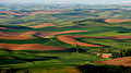
The hills of Palouse in southeast Washington
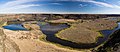
Dry Falls in the Channeled Scablands semi-desert that dominates much of eastern Washington

A truck hauling east on Highway 2 near Waterville


Individual evidence
- ^ WSP Eastside Recruiter Returns to Face Recruitment Challenge . Washington State Patrol Government and Media Relations. September 8, 2010. Archived from the original on November 3, 2010. Retrieved on December 27, 2010.
- ↑ Eastside steelheading enters last month , Bellingham Herald. March 4, 2010. Retrieved on December 27, 2010. ( Page no longer available , search in web archives )
- ^ Eastside Earthquakes Get Attention At Conference In Yakima , Oregon Public Broadcasting . October 17, 2007. Retrieved December 27, 2010.
- ↑ The population figures are the most recent from the corresponding English-language Wikipedia articles or from the list of cities in Washington on the English-language Wikipedia.
- ↑ WAC 222-16-010 . In: Washington Administrative Code . Washington State Legislature . Retrieved January 13, 2018.
- ↑ RICHLAND, WASHINGTON (457015) . Western Regional Climate Center. Retrieved March 11, 2018.
- ↑ KENNEWICK, WASHINGTON (454154) . Western Regional Climate Center . Retrieved March 11, 2018.
- ↑ NowData - NOAA Online Weather Data . National Oceanic and Atmospheric Administration . Retrieved March 11, 2018.
- ↑ SPOKANE INTL AP, WASHINGTON (457938) . Western Regional Climate Center. Retrieved March 11, 2018.
- ↑ Spokane, Washington (457,933) . Western Regional Climate Center . Retrieved March 11, 2018.
- ↑ NOWData - NOAA Online Weather Data . NOAA . Retrieved March 11, 2018.
- ↑ Lawmakers want to make eastern Wash. its own state . In: USA TODAY . Retrieved January 10, 2017.