
Inland Northwest (United States)

The Inland Northwest ( Inland Northwest or Inland Empire ) is a region that is immediately east of the Pacific Northwest . Its center is in the greater Spokane area and includes all of east Washington and all of north Idaho . The region also includes tri-cities . Western Montana , that is, the part of Montana west of the continental divide , is often considered part of the region.
The following counties belong to the region:
- Washington: Adams , Asotin County , Benton , Chelan , Columbia , Douglas , Ferry , Franklin , Garfield , Grant , Kittitas , Klickitat , Lincoln , Okanogan , Pend Oreille , Spokane , Stevens , Walla Walla , Whitman, and Yakima
- Idaho: Benewah , Bonner , Boundary , Clearwater , Idaho , Kootenai , Latah , Lewis , Nez Perce, and Shoshone
- Montana (occasionally attributed): Flathead , Lake , Lincoln , Mineral , Missoula , Ravalli, and Sanders
The United States Census Bureau estimated the population at 2,240,645 in 2016, making the region the size of New Mexico in terms of population . The Canadian counterpart north of the border is the British Columbia Interior .
geography
The region is bounded by the Cascade Range to the west and by the Rocky Mountains (along the ridge of the remote and rugged Cabinet Mountains ) to the east, the Blue Mountains and the foothills of the Wallowa Mountains to the south and southeast; it also includes the Columbia River Basin (or Columbia Plateau ). Between the three mountain ranges there are large, expansive areas of semi-arid steppe , parts of which are irrigated by the Columbia Basin Project so that intensive agriculture can be practiced in central Washington. The Palouse , original home of the Appaloosa is another agricultural region located in the rolling hills of South East Washington and extending as far as into Idaho. Northern Idaho is home to the Silver Valley , an ore-rich region of the Coeur d'Alene Mountains known for its mining heritage that dates back to the 1880s.
The largest city, Spokane ("The Lilac City", dt. About "The Lilac City") is located near the transition from the arid, largely unforested Columbia Plateau to the lushly forested Selkirk Mountains . The urban area extends eastward along Interstate 90 into Idaho in a corridor through the Spokane River Valley to Post Falls, Idaho and the town of Coeur d'Alene (Idaho) on the north shore of Lake Coeur d'Alene . The parts of northeast Washington and northern Idaho that count towards the inland northwest are mountainous and forested, and the main ridge of the Bitterroot Range in the Rocky Mountains forms part of the eastern border of the region, while the Columbia River forms a significant part of the southern border represents.
climate
In east Washington, the climate is generally semi-arid , while the Idaho Panhandle has mostly a humid continental climate .
gallery
Hills near West Richland, Washington

Hangman Creek (also known as Latah Creek ): A major historical site in the Pacific Northwest
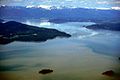
Lake Pend Oreille (approx. 1,200 ft (approx. 370 m)) deep

The Oregon Butte in the Wenaha – Tucannon Wilderness
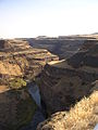
Palouse Canyon

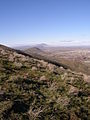
The Palouse from Steptoe Butte seen from
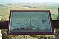
Information board on the summit of Steptoe Butte


Largest cities (by population)
- Spokane (217,300)
- Spokane Valley (94,919)
- Yakima (93,701)
- Kennewick (80,280)
- Pasco (71,680)
- Richland (54,150)
- Coeur d'Alene (52,593)
- Post Falls (34,371)
- Wenatchee (34,060)
- Walla Walla (33,840)
- Lewiston (33,334)
- Pullman (32,280)
- Moscow (25,984)
- Moses Lake (22,720)
- Ellensburg (19,550)
- Sunnyside (16,640)
- Hayden (14,760)
- West Richland (14,660)
- East Wenatchee (13,600)
- Cheney (11,880)
- Grandview (11,170)
See also
Individual evidence
- ↑ Stratton, David H. (Eds.): Spokane & the Inland Empire: An Interior Pacific Northwest Anthology . Washington State University, 2004, ISBN 0-87422-277-X .
Coordinates: 47 ° 0 ′ 0 ″ N , 118 ° 0 ′ 0 ″ W.