Kamvounia
|
Kamvounia Parish Δημοτική Ενότητα Καμβουνίων (Καμβούνια) |
||
|---|---|---|
|
|
||
| Basic data | ||
| State : |
|
|
| Region : |
Western Macedonia
|
|
| Regional District : | Kozani | |
| Municipality : | Servia-Velvendo | |
| Geographic coordinates : | 40 ° 3 ' N , 21 ° 53' E | |
| Height above d. M .: | 674 m (average) |
|
| Area : | 149.535 km² | |
| Residents : | 1,539 (2011) | |
| Population density : | 10.3 inhabitants / km² | |
| Code No .: | 140403 | |
| Structure: | 3 local communities | |
| Located in the Servia-Velvendo municipality and Kozani regional district | ||
Kamvounia ( Greek Καμβούνια ( n. Pl. )) Is a municipality in the municipality of Servia-Velvendo in the Greek region of Western Macedonia . It was named after the mountains of the same name .
location
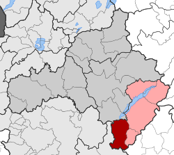
The municipality of Kamvounia is located in the southwest of the municipality of Servia-Velvendo on the border with the neighboring municipality of Deskati .
Administrative division
The municipality of Kamvounia was founded from three rural municipalities as part of the territorial reform in 1997 and became one of four municipal districts in the newly founded municipality of Servia-Velvendo in accordance with the administrative reform in 2010 . The administrative seat was Tranovalto.
| Local community | Greek name | code | Area (km²) | 2001 residents | Residents 2011 | Villages and settlements |
|---|---|---|---|---|---|---|
| Tranovalto | Τοπική Κοινότητα Τρανοβάλτου | 14040301 | 79.245 | 1084 | 790 | Tranovalto, Lazarades, Frourio |
| Elati | Τοπική Κοινότητα Ελάτης | 14040302 | 39.982 | 568 | 415 | Elati |
| Microvalto | Τοπική Κοινότητα Μικροβάλτου | 14040303 | 30.308 | 605 | 334 | Mikrovalto, Moni Stavou |
| total | 140403 | 149.535 | 2257 | 1539 | ||
Individual evidence
- ↑ Results of the 2011 census at the National Statistical Service of Greece (ΕΛ.ΣΤΑΤ) (Excel document, 2.6 MB)
- ↑ Law 2539/1997, «Συγκρότηση της Πρωτοβάθμιας Τοπικής Αυτοδιοίκησης." ΦΕΚ 244A / December 4, 1997, Άρθρο 1. Σύσταση δήμων και κοινοτήτων. P. 8813. PDF Online (Greek)

