Karaginski
| Karaginski | |
|---|---|
| Waters | Bering Sea |
| Geographical location | 58 ° 55 ' N , 164 ° 20' E |
| length | 100 km |
| width | 27 km |
| surface | 2 404 km² |
| Highest elevation | Gora Sakonoval ' 920 m |
| Residents | uninhabited |
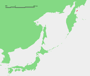
Karaginski ( Russian Карагинский ) is an island in the bay of the same name in the Bering Sea in the Far East of Russia , northeast of the Kamchatka Peninsula .
geography
The area of the island is 2,404 km², the length of the island from southwest to northeast about 100 km, the maximum width 27 km. It is separated from the mainland in the west by Lütkestrasse , the narrowest point of which measures almost 30 km between the Kostroma spit on the mainland and the spit protruding 13 km from Karaginski and ending in the Semjonow Cape . The west coast of the island is flat, while the east coast facing the ocean is steep and rocky. Several parallel mountain chains run along the island, culminating in the 920 m high Vysokaya ("High Mountain"). The northern tip of the island forms the Golenishchev Cape , the southern tip the Krasheninnikov Cape .
Administratively, the island belongs to the Karaginsky Rajon of the Kamchatka Region (until 2007 the Koryak Autonomous Okrug ). The island is not always inhabited.
climate
The island's climate is characterized by short, cool summers (July mean temperature +11.8 ° C) and long, relatively mild (January mean temperature −11 ° C, absolute minimum only −18.9 ° C) winters. The winters, which last around seven months, are extremely rainy: the snow depths can reach five meters.
Flora and fauna
The island is mostly covered by tundra , next to it grows dwarf pine and alder knee wood as well as occasional mountain ash and birch .
Karaginski is an important migratory and breeding area, especially for water birds, and therefore one of the Ramsar areas of Russia. The island belongs to the distribution area of the giant sea eagle .
Web links
- Karaginski on the Ramsar website (English)
