Karakol (Issyk Kul)
|
Karakol Каракол |
||
| Data | ||
| location | Issyk Kul ( Kyrgyzstan ) | |
| River system | Karakol | |
| Headwaters |
Terskej-Alatau 42 ° 12 ′ 32 " N , 78 ° 28 ′ 45" E |
|
| muzzle |
Issyk-Kul coordinates: 42 ° 34 ′ 50 " N , 78 ° 18 ′ 2" E 42 ° 34 ′ 50 " N , 78 ° 18 ′ 2" E |
|
| Mouth height |
1607 m
|
|
| length | 50 km | |
| Catchment area | 394 km² | |
| Outflow A Eo : 325 km² |
MQ Mq |
6.6 m³ / s 20.3 l / (s km²) |
| Right tributaries | Kurgaktor | |
| Medium-sized cities | Karakol | |
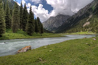
The Karakol ( kirghiz Каракол ) is a tributary of the Issyk Kul -Sees in Kyrgyzstan ( Central Asia ).
The Karakol rises in the central part of the Terskej-Alatau . It is fed by its glaciers . The Karakol flows through a mountain valley in a northerly direction. The Kurgaktor , outflow of the Ala-Kul , flows into the river from the right. The Karakol leaves the mountains and flows through the regional capital of the same name, Karakol , located in the lowlands east of Lake Issyk Kul , before flowing into a bay in the southeast of Issyk Kul, 10 km further northwest. The Karakol has a length of 50 km. It drains an area of 394 km². The mean discharge is 6.6 m³ / s.
Web links
Commons : Karakol - collection of images, videos and audio files

