
Karakol
|
Karakol Каракол |
|||||
|
|||||
| Basic data | |||||
|---|---|---|---|---|---|
| State : |
|
||||
| Territory : | Issyk Kul | ||||
| Coordinates : | 42 ° 29 ' N , 78 ° 24' E | ||||
| Height : | 1780 m | ||||
| Area : | 48.05 km² | ||||
| Residents : | 68,800 (2010) | ||||
| Population density : | 1,432 inhabitants per km² | ||||
| Telephone code : | (+996) 3922 | ||||
| Postal code : | 722200 | ||||
| Structure and administration | |||||
| Community type : | city | ||||


Karakol ( Russian / Kyrgyz Каракол , meaning “black lake” missing document , “black hand”; Prschewalsk 1889–1920 and 1939–1991 ) is a city of about 68,800 inhabitants in Kyrgyzstan .
It is located approximately 386 km east of Bishkek , 5 km south of the eastern end of the Issyk Kul -Sees and about 150 km from the present Chinese border at an altitude from 1,690 to 1,825 m. It is the administrative capital of the Issyk Kul Oblast . Karakol is not to be confused with the much smaller town of Karakol in the Jalal-Abad Region . The Karakol River of the same name flows through the city .
history
Karakol has a long history as a trading post due to its strategic location on one of the passes where the Silk Road crosses the Tianshan .
At the beginning of the 19th century, the Kokand Khanate extended to Issyk Kul . The Kyrgyz tribal leaders could not resist the militarily stronger khanate and therefore sought help from the Kazakh tribes, the Russians and the Chinese. During the expansion of the Tsarist empire in Central Asia, the Russian military was only able to bring the region around Issyk Kul under their control late. In 1869 Karakol became a Russian administrative center with a base for the Cossacks . The city itself was founded on July 1, 1869, and developed when explorers came to the area to explore the mountainous region between China and Kyrgyzstan . After 1877, the city grew rapidly, mainly because Chinese Muslims ( Dungans ) came to the city fleeing religious persecution from the nearby Chinese region of Sinkiang . Here they built a mosque entirely out of wood, supposedly without using a nail.

In 1888, when the Russian military and geographer Nikolai Prschewalsky died of typhus in Karakol while preparing for a research trip to Tibet and was buried there, the city was renamed Prschewalsk in his honor . After local protests it was renamed again to Karakol in 1920, but then again to Prschewalsk in 1939. It was not until 1991, after the independence of Kyrgyzstan, that the city was given its original name back.
At the beginning of the 20th century there was an influx of Russian settlers, the first schools and other public buildings were opened. After the founding of the Soviet Union , it took a long time before Soviet control over the region could be established, after which numerous investments were made in economic development, including the construction of Karakol Airport in 1934 . In 1939 the Issyk Kul area was established, Karakol was raised to its center, border troops were stationed. In 1940 the Issyk Kul State University was founded.
The population census of 1979 showed 50,800 inhabitants, the 1999 census showed 65,400 inhabitants. Most of the Kyrgyz people and smaller groups of Russians , Ukrainians and Dungans live in Karakol .
Today Karakol lives mainly from trade, light industry, the processing of agricultural products and tourism. Since 1991, tourism has been developing due to travelers taking the Turpan Silk Road towards Bishkek . In 1996 a free economic zone was established.
Attractions

Przhevalsky's grave and the Przhevalsky Museum are located about 12 km northwest of Karakol in Pristan-Przhevalsky, in a memorial park on the bank of an arm of Lake Issyk Kul , where the Soviet Navy carried out its secret torpedo tests and the Russian Navy is now a test base for the underground Operates boat hunting. Sven Hedin visited the grave in 1891.
The town offers a wooden mosque , which was built by Chinese skilled workers and local Dungans between 1907 and 1910 for the local Dungans, completely without metal nails, and a wooden Orthodox church from 1895, which was used as a club and warehouse during the Soviet era afterwards it was restored and is in use again today.
In terms of tourism, Karakol is a starting point for trekking tours and is of interest to mountaineers aiming at the Tianshan mountains . The "Kyrgyzstan Trail", a long-distance hiking trail redesigned in 2007, runs close to the city and opens up and connects the mountain ranges of the Issyk Kul region in Kyrgyzstan.
The Karakol cattle market , in addition to its economic importance for the city, has meanwhile also gained tourist relevance as a popular stop for travelers in the region.

sons and daughters of the town
- Marlen Spindler (1931–2003), Russian nonconformist
- Jelena Proskurakowa (* 1985), judoka
- Atai Omursakow (* 1990), dancer and founder of the robo-dance group Тумар КР, which was successful in various talent shows
- Darja Maslowa (* 1995), track and field athlete
gallery

Inside of the Dungan Mosque

Traditional musicians in Karakol
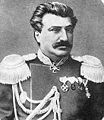
Nikolai M. Prschewalski, died in Karakol in 1888


See also
Web links
- Karakol (Russian)
Individual evidence
- ↑ a b c d e f g h i Rafis Abazov: Historical dictionary of Kyrgyzstan . Scarecrow Press, Lanham MD 2004, ISBN 0-8108-4868-6 , pp. 156-158 .
- ↑ Kay Tschersich: Kyrgyzstan, Terskej-Alatau-Traverse from Kyzyl Suu to Ak Suu, Trekking in Tienschan (OutdoorHandbuch, Volume 151). Conrad Stein Verlag, Welver 2005, ISBN 3-89392-551-1 , p. 84.
- ^ RIA Novosti, April 6, 2009: Russia pays with weapons for military presence in Kyrgyzstan ( Memento of April 10, 2009 in the Internet Archive )